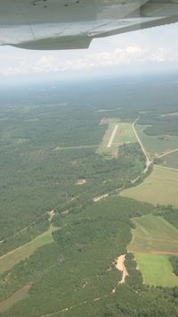
Latest photos of Abbeville Municipal Airport (0J0)
-
 by dms65aaf
-
 by dms65aaf
Location & QuickFacts
| FAA Information Effective: | 2013-12-12 |
| Airport Identifier: | 0J0 |
| Airport Status: | Operational |
| Longitude/Latitude: | 085-14-17.9100W/31-36-00.8000N
-85.238308/31.600222 (Estimated) |
| Elevation: | 469 ft / 142.95 m (Surveyed) |
| Land: | 36 acres |
| From nearest city: | 3 nautical miles N of Abbeville, AL |
| Location: | Henry County, AL |
| Magnetic Variation: | 01W (1985) |
Owner & Manager
| Ownership: | Publicly owned |
| Owner: | City Of Abbeville |
| Address: | Po Box 427
Abbeville, AL 36310 |
| Phone number: | 334-585-6444 |
| Manager: | Pam Ward |
| Address: | Po Box 427
Abbeville, AL 36310 |
| Phone number: | 334-585-6444 |
Airport Operations and Facilities
| Airport Use: | Open to public |
| Wind indicator: | Yes |
| Segmented Circle: | No |
| Control Tower: | No |
| Lighting Schedule: | SS-SR |
| Landing fee charge: | No |
| Sectional chart: | New Orleans |
| Region: | ASO - Southern |
| Boundary ARTCC: | ZJX - Jacksonville |
| Tie-in FSS: | ANB - Anniston |
| FSS on Airport: | No |
| FSS Toll Free: | 1-800-WX-BRIEF |
| NOTAMs Facility: | ANB (NOTAM-d service avaliable) |
| Federal Agreements: | N |
Airport Communications
| CTAF: | 122.800 |
| Unicom: | 122.800
UNICOM IS LCTD AT POLICE STATION. |
Airport Services
| Airframe Repair: | NONE |
| Power Plant Repair: | NONE |
Runway Information
Runway 17/35
| Dimension: | 2900 x 80 ft / 883.9 x 24.4 m |
| Surface: | ASPH, Good Condition |
| Edge Lights: | Medium |
| |
Runway 17 |
Runway 35 |
| Longitude: | 085-14-20.2000W | 085-14-15.6200W |
| Latitude: | 31-36-14.9900N | 31-35-46.5600N |
| Elevation: | 463.00 ft | 463.00 ft |
| Traffic Pattern: | Left | Left |
| Markings: | Basic, Good Condition | Basic, Good Condition |
| Displaced threshold: | 300.00 ft | 0.00 ft |
Radio Navigation Aids
| ID |
Type |
Name |
Ch |
Freq |
Var |
Dist |
| IWJ | NDB | Blaak | | 344.00 | 03W | 23.2 nm |
| HYE | NDB | Hanchey | | 221.00 | 00E | 25.3 nm |
| LOR | NDB | Lowe | | 269.00 | 03W | 29.6 nm |
| OZ | NDB | Ruckr | | 212.00 | 00E | 37.2 nm |
| XNE | NDB | Spring Hill | | 281.00 | 00E | 38.0 nm |
| BVG | NDB | Boll Weevil | | 352.00 | 03E | 41.3 nm |
| AWS | NDB | Lawson | | 335.00 | 02W | 43.1 nm |
| SMY | NDB | Soyya | | 329.00 | 02W | 43.8 nm |
| TO | NDB | Blood | | 365.00 | 01W | 46.4 nm |
| BKK | NDB | Tri County | | 275.00 | 02W | 48.7 nm |
| HEY | VOR | Hanchey | | 110.60 | 02E | 25.2 nm |
| EDN | VOR | Enterprise | | 116.60 | 03W | 38.7 nm |
| FYL | VOR | Tri County | | 108.40 | 08W | 49.4 nm |
| OZR | VOR/DME | Cairns | 049X | 111.20 | 02E | 32.0 nm |
| LSF | VOR/DME | Lawson | 051X | 111.40 | 02W | 45.7 nm |
| RRS | VORTAC | Wiregrass | 053X | 111.60 | 02E | 21.4 nm |
| EUF | VORTAC | Eufaula | 029X | 109.20 | 02E | 21.7 nm |
| PZD | VORTAC | Pecan | 108X | 116.10 | 02W | 48.5 nm |
| MAI | VORTAC | Marianna | 087X | 114.00 | 00E | 49.3 nm |