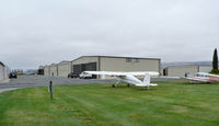
Latest photos of Frazier Lake Airpark Airport (1C9)
-
 by Bill Larkins
-
 by Tom Reeves
Location & QuickFacts
| FAA Information Effective: | 2013-12-12 |
| Airport Identifier: | 1C9 |
| Airport Status: | Operational |
| Longitude/Latitude: | 121-27-45.5000W/36-57-10.2000N
-121.462639/36.952833 (Estimated) |
| Elevation: | 152 ft / 46.33 m (Surveyed) |
| Land: | 155 acres |
| From nearest city: | 8 nautical miles NW of Hollister, CA |
| Location: | San Benito County, CA |
| Magnetic Variation: | 15E (1985) |
Owner & Manager
| Ownership: | Privately owned |
| Owner: | Frazier Lake Airpark |
| Address: | Po Box 513
San Martin, CA 95046 |
| Phone number: | 408-242-3156 |
| Manager: | Doug Jackson
PRESIDENT NOT LOCATED ON ARPT. |
| Address: | 1155 Stoney Brook Drive
Hollister, CA 95033 |
| Phone number: | 831-638-1068 |
Airport Operations and Facilities
| Airport Use: | Open to public |
| Wind indicator: | Yes |
| Segmented Circle: | Yes |
| Control Tower: | No |
| Lighting Schedule: | SEE RMK
ACTVT LIRL RY 05/23 & REIL RY 23- CTAF. |
| Landing fee charge: | No |
| Sectional chart: | San Francisco |
| Region: | AWP - Western-Pacific |
| Boundary ARTCC: | ZOA - Oakland |
| Tie-in FSS: | OAK - Oakland |
| FSS on Airport: | No |
| FSS Toll Free: | 1-800-WX-BRIEF |
| NOTAMs Facility: | OAK (NOTAM-d service avaliable) |
Airport Communications
| CTAF: | 123.050 |
| Unicom: | 123.050 |
Runway Information
Runway 05/23
| Dimension: | 2500 x 100 ft / 762.0 x 30.5 m |
| Surface: | TURF, Good Condition
TYPICAL WATER DEPTH 2.5 FT. WATER DEPTH NOTED AS SHALLOW AS 1 1/2 FEET DEEP. |
| Edge Lights: | Low |
| |
Runway 05 |
Runway 23 |
| Longitude: | 121-28-00.4867W | 121-27-32.5019W |
| Latitude: | 36-57-06.0175N | 36-57-16.3563N |
| Elevation: | 152.00 ft | 153.00 ft |
| Alignment: | 65 | 127 |
| Traffic Pattern: | Left | Right |
| Runway End Identifier: | | Yes |
| Obstruction: | 40 ft pline, 1350.0 ft from runway, 33:1 slope to clear | , 50:1 slope to clear |
Runway 05W/23W
| Dimension: | 3000 x 60 ft / 914.4 x 18.3 m |
| Surface: | WATER, Good Condition
TYPICAL WATER DEPTH 2.5 FT. WATER DEPTH NOTED AS SHALLOW AS 1 1/2 FEET DEEP. |
| |
Runway 05W |
Runway 23W |
| Longitude: | 121-28-01.4900W | 121-27-27.9400W |
| Latitude: | 36-57-03.1400N | 36-57-15.5900N |
| Traffic Pattern: | Left | Right |
| Obstruction: | 40 ft pline, 1100.0 ft from runway, 27:1 slope to clear | , 50:1 slope to clear |
Radio Navigation Aids
| ID |
Type |
Name |
Ch |
Freq |
Var |
Dist |
| PDG | NDB | Pajar | | 327.00 | 17E | 16.8 nm |
| UAD | NDB | Chualar | | 263.00 | 16E | 27.8 nm |
| TCY | NDB | Tracy | | 203.00 | 15E | 44.5 nm |
| LV | NDB | Reiga | | 374.00 | 16E | 45.7 nm |
| NUQ | TACAN | Moffett | 123X | | 17E | 40.5 nm |
| SJC | VOR/DME | San Jose | 088X | 114.10 | 16E | 34.3 nm |
| MOD | VOR/DME | Modesto | 093X | 114.60 | 17E | 47.2 nm |
| SNS | VORTAC | Salinas | 120X | 117.30 | 17E | 18.6 nm |
| PXN | VORTAC | Panoche | 073X | 112.60 | 16E | 35.9 nm |
| BSR | VORTAC | Big Sur | 087X | 114.00 | 16E | 47.2 nm |
| OSI | VORTAC | Woodside | 086X | 113.90 | 17E | 47.3 nm |