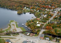
Latest photos of Currier's Seaplane Base (21M)
-
 by Currier
-
 by Currier
Location & QuickFacts
| FAA Information Effective: | 2013-12-12 |
| Airport Identifier: | 21M |
| Airport Status: | Operational |
| Longitude/Latitude: | 069-37-09.5000W/45-28-41.9000N
-69.619306/45.478306 (Estimated) |
| Elevation: | 1029 ft / 313.64 m (Estimated) |
| Land: | 0 acres |
| From nearest city: | 0 nautical miles N of Greenville Junction, ME |
| Location: | Piscataquis County, ME |
| Magnetic Variation: | 18W (2000) |
Owner & Manager
| Ownership: | Privately owned |
| Owner: | Roger Currier |
| Address: | Po Box 351
Greenville Junction, ME 04442 |
| Phone number: | 207-695-2778 |
| Manager: | Roger Currier |
| Address: | Po Box 351
Greenville Junction, ME 04442 |
| Phone number: | 207-695-2778 |
Airport Operations and Facilities
| Airport Use: | Open to public |
| Segmented Circle: | No |
| Control Tower: | No |
| Sectional chart: | Montreal |
| Region: | ANE - New England |
| Boundary ARTCC: | ZBW - Boston |
| Tie-in FSS: | BGR - Bangor |
| FSS Toll Free: | 1-800-WX-BRIEF |
| NOTAMs Facility: | BGR |
Airport Services
| Airframe Repair: | NONE |
| Power Plant Repair: | NONE |
Runway Information
Runway 18W/36W
| Dimension: | 10000 x 3000 ft / 3048.0 x 914.4 m |
| Surface: | WATER, |
| |
Runway 18W |
Runway 36W |
| Longitude: | 069-37-10.4424W | 069-37-08.6559W |
| Latitude: | 45-29-31.2183N | 45-27-52.4724N |
| Elevation: | 1029.00 ft | 1029.00 ft |
| Alignment: | 127 | 127 |
| Traffic Pattern: | Left | Right |
Radio Navigation Aids
| ID |
Type |
Name |
Ch |
Freq |
Var |
Dist |
| XQA | NDB | Squaw | | 236.00 | 18W | 3.5 nm |
| LNT | NDB | Milnot | | 344.00 | 19W | 46.1 nm |
| LRG | NDB | Lincoln | | 216.00 | 19W | 46.2 nm |
| BUP | NDB | Burnham | | 348.00 | 18W | 48.2 nm |
| MLT | VOR/DME | Millinocket | 126X | 117.90 | 20W | 46.9 nm |
| BGR | VORTAC | Bangor | 095X | 114.80 | 19W | 49.6 nm |