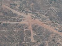
Latest photo of Moreton Airpark Airport (23AZ)
-
 by John Meneely
Location & QuickFacts
| FAA Information Effective: | 2013-12-12 |
| Airport Identifier: | 23AZ |
| Airport Status: | Operational |
| Longitude/Latitude: | 112-49-32.6490W/34-01-10.1020N
-112.825736/34.019473 (Estimated) |
| Elevation: | 2455 ft / 748.28 m (Surveyed) |
| Land: | 250 acres |
| From nearest city: | 5 nautical miles NW of Wickenburg, AZ |
| Location: | Yavapai County, AZ |
| Magnetic Variation: | 13E (1985) |
Owner & Manager
| Ownership: | Privately owned |
| Owner: | Moreton Airpark, Llp |
| Address: | 7526 E. Whispering Winds Road
Scottsdale, AZ 85250 |
| Phone number: | 602-315-0323 |
| Manager: | Daniel P. Kropp |
| Address: | 7526 E. Whispering Winds Road
Scottsdale, AZ 85250 |
| Phone number: | 602-315-0323 |
Airport Operations and Facilities
| Airport Use: | Private |
| Wind indicator: | Yes |
| Segmented Circle: | No |
| Control Tower: | No |
| Lighting Schedule: | SEE RMK
FOR LIRL RY 13/31 CALL 602-315-0323. |
| Landing fee charge: | No |
| Sectional chart: | Phoenix |
| Region: | AWP - Western-Pacific |
| Boundary ARTCC: | ZAB - Albuquerque |
| Tie-in FSS: | PRC - Prescott |
| FSS on Airport: | No |
| FSS Toll Free: | 1-800-WX-BRIEF |
Airport Services
| Airframe Repair: | NONE |
| Power Plant Repair: | NONE |
Runway Information
Runway 09/27
| Dimension: | 2000 x 75 ft / 609.6 x 22.9 m |
| Surface: | DIRT, |
| |
Runway 09 |
Runway 27 |
| Traffic Pattern: | Left | Left |
Runway 13/31
| Dimension: | 4500 x 75 ft / 1371.6 x 22.9 m |
| Surface: | DIRT, |
| Edge Lights: | Low |
| |
Runway 13 |
Runway 31 |
| Elevation: | 2455.00 ft | 0.00 ft |
| Traffic Pattern: | Left | Left |
Runway 17/35
| Dimension: | 2600 x 72 ft / 792.5 x 21.9 m |
| Surface: | DIRT, |
| |
Runway 17 |
Runway 35 |
| Traffic Pattern: | Left | Left |
Radio Navigation Aids
| ID |
Type |
Name |
Ch |
Freq |
Var |
Dist |
| LUF | TACAN | Luke | 077X | | 13E | 36.5 nm |
| BXK | VORTAC | Buckeye | 043X | 110.60 | 14E | 34.0 nm |
| DRK | VORTAC | Drake | 088X | 114.10 | 14E | 44.5 nm |
| PRC | VOT | Prescott | | 110.00 | | 43.0 nm |