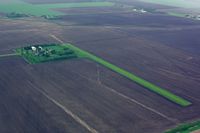
Latest photo of Blue Sky Airport (3MN7)
-
 by Timothy Aanerud
Location & QuickFacts
| FAA Information Effective: | 2013-12-12 |
| Airport Identifier: | 3MN7 |
| Airport Status: | Operational |
| Longitude/Latitude: | 096-35-42.0000W/46-48-01.8600N
-96.595000/46.800517 (Estimated) |
| Elevation: | 927 ft / 282.55 m (Estimated) |
| Land: | 0 acres |
| From nearest city: | 3 nautical miles NE of Sabin, MN |
| Location: | Clay County, MN |
| Magnetic Variation: | 05E (2000) |
Owner & Manager
| Ownership: | Privately owned |
| Owner: | Brett Nordick |
| Address: | 6437 S 100 St
Glyndon, MN 56547 |
| Phone number: | 218-789-7632 |
| Manager: | Brett Nordick |
| Address: | 6437 S 100 St
Glyndon, MN 56547 |
| Phone number: | 218-789-7632 |
Airport Operations and Facilities
| Airport Use: | Private |
| Segmented Circle: | No |
| Control Tower: | No |
| Sectional chart: | Twin Cities |
| Region: | AGL - Great Lakes |
| Boundary ARTCC: | ZMP - Minneapolis |
| Tie-in FSS: | PNM - Princeton |
| FSS Toll Free: | 1-800-WX-BRIEF |
Runway Information
Runway 18/36
| Dimension: | 2200 x 75 ft / 670.6 x 22.9 m |
| Surface: | TURF, |
| |
Runway 18 |
Runway 36 |
| Traffic Pattern: | Left | Left |
| Obstruction: | 15 ft road, 300.0 ft from runway | |
Radio Navigation Aids
| ID |
Type |
Name |
Ch |
Freq |
Var |
Dist |
| AA | NDB | Kenie | | 365.00 | 06E | 15.5 nm |
| BWP | NDB | Breckenridge-wahpeton | | 233.00 | 05E | 33.4 nm |
| DTL | VOR/DME | Detroit Lakes | 049X | 111.20 | 05E | 29.2 nm |
| FFM | VOR/DME | Fergus Falls | 041X | 110.40 | 05E | 35.7 nm |
| FAR | VORTAC | Fargo | 109X | 116.20 | 09E | 10.9 nm |