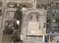
Latest photos of Shands Cair Heliport (63FL)
-
 by RGF
-
 by RGF
Location & QuickFacts
| FAA Information Effective: | 2013-12-12 |
| Airport Identifier: | 63FL |
| Airport Status: | Operational |
| Longitude/Latitude: | 082-21-01.3760W/29-38-07.8830N
-82.350382/29.635523 (Estimated) |
| Elevation: | 94 ft / 28.65 m (Estimated) |
| Land: | 0 acres |
| From nearest city: | 3 nautical miles SW of Gainesville, FL |
| Location: | Alachua County, FL |
| Magnetic Variation: | 02W (1985) |
Owner & Manager
| Ownership: | Privately owned |
| Owner: | Shands Hospital |
| Address: | Box 100335
Gainesville, FL 32610 |
| Phone number: | 352-265-0222 |
| Manager: | Chief Pilot |
| Address: | 1600 Sw Snealy Dr.
Gainesville, FL 32610 |
| Phone number: | 352-265-0222 |
Airport Operations and Facilities
| Airport Use: | Private
MEDICAL |
| Wind indicator: | Yes |
| Segmented Circle: | No |
| Control Tower: | No |
| Lighting Schedule: | SS-SR |
| Landing fee charge: | No |
| Sectional chart: | Jacksonville |
| Region: | ASO - Southern |
| Boundary ARTCC: | ZJX - Jacksonville |
| Tie-in FSS: | GNV - Gainesville |
| FSS on Airport: | No |
| FSS Toll Free: | 1-800-WX-BRIEF |
Runway Information
Helipad H1
| Dimension: | 60 x 60 ft / 18.3 x 18.3 m |
| Surface: | CONC, Good Condition |
| |
Runway H1 |
Runway |
| Traffic Pattern: | Left | Left |
Radio Navigation Aids
| ID |
Type |
Name |
Ch |
Freq |
Var |
Dist |
| GN | NDB | Wynds | | 269.00 | 04W | 9.5 nm |
| IAK | NDB | Palatka | | 243.00 | 05W | 28.2 nm |
| LCQ | NDB | Lake City | | 204.00 | 03W | 35.1 nm |
| HEG | NDB | Herlong | | 332.00 | 02W | 47.7 nm |
| NZC | TACAN | Cecil/dcmsnd | 088X | | 04W | 43.1 nm |
| VQQ | VOR | Cecil | | 117.90 | 03W | 42.2 nm |
| GNV | VORTAC | Gators | 109X | 116.20 | 04W | 5.3 nm |
| OCF | VORTAC | Ocala | 084X | 113.70 | 00E | 28.3 nm |
| CTY | VORTAC | Cross City | 057X | 112.00 | 02W | 36.6 nm |