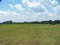
Latest photo of Cox Field Airport (81NC)
-
 by J.B. Barbour
Location & QuickFacts
| FAA Information Effective: | 2013-12-12 |
| Airport Identifier: | 81NC |
| Airport Status: | Operational |
| Longitude/Latitude: | 078-44-24.0000W/34-02-27.0000N
-78.740000/34.040833 (Estimated) |
| Elevation: | 50 ft / 15.24 m () |
| Land: | 0 acres |
| From nearest city: | 10 nautical miles SE of Tabor City, NC |
| Location: | Columbus County, NC |
| Magnetic Variation: | () |
Owner & Manager
| Ownership: | Privately owned |
| Owner: | William C. Cox Ii |
| Address: | 6952 Ramsey Ford Road
Tabor City, NC 28463 |
| Phone number: | 910-840-9154 |
| Manager: | William C. Cox Ii |
| Address: | 6952 Ramsey Ford Road
Tabor City, NC 28463 |
| Phone number: | 910-840-9154 |
Airport Operations and Facilities
| Airport Use: | Private |
| Wind indicator: | Yes |
| Control Tower: | No |
| Sectional chart: | Charlotte |
| Region: | ASO - Southern |
| Boundary ARTCC: | ZJX - Jacksonville |
| Tie-in FSS: | RDU - Raleigh |
| FSS Toll Free: | 1-800-WX-BRIEF |
Runway Information
Runway 04/22
| Dimension: | 3300 x 50 ft / 1005.8 x 15.2 m |
| Surface: | TURFRVL, Good Condition |
| |
Runway 04 |
Runway 22 |
| Traffic Pattern: | Left | Left |
Radio Navigation Aids
| ID |
Type |
Name |
Ch |
Freq |
Var |
Dist |
| CPC | NDB | Camp | | 227.00 | 07W | 13.9 nm |
| HYW | NDB | Horry | | 370.00 | 08W | 23.4 nm |
| MAO | NDB | Marion | | 388.00 | 06W | 30.8 nm |
| TGQ | NDB | Elizabethtown | | 398.00 | 08W | 31.4 nm |
| SUT | NDB | Yaupon | | 233.00 | 08W | 33.9 nm |
| JB | NDB | Jigel | | 384.00 | 08W | 36.2 nm |
| RSY | NDB | Robeson | | 359.00 | 08W | 37.9 nm |
| CLB | NDB | Carolina Beach | | 216.00 | 04W | 39.0 nm |
| DLC | NDB | Dillon | | 274.00 | 05W | 39.8 nm |
| HEK | NDB | Stuckey | | 236.00 | 06W | 43.4 nm |
| LBT | VOR | Lumberton | | 110.00 | 08W | 37.6 nm |
| CRE | VORTAC | Grand Strand | 123X | 117.60 | 03W | 13.7 nm |
| ILM | VORTAC | Wilmington | 117X | 117.00 | 07W | 46.9 nm |
| FLO | VORTAC | Florence | 099X | 115.20 | 03W | 47.1 nm |