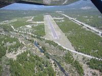
Latest photo of Cabin Creek Landing Airport (97MT)
-
 by Gerald W. Hurst
Location & QuickFacts
| FAA Information Effective: | 2013-12-12 |
| Airport Identifier: | 97MT |
| Airport Status: | Operational |
| Longitude/Latitude: | 114-40-34.5000W/48-04-24.4900N
-114.676250/48.073469 (Estimated) |
| Elevation: | 3999 ft / 1218.90 m (Estimated) |
| Land: | 140 acres |
| From nearest city: | 2 nautical miles SW of Marion, MT |
| Location: | Flathead County, MT |
| Magnetic Variation: | () |
Owner & Manager
| Ownership: | Privately owned |
| Owner: | Cabin Creek Landing Llc |
| Address: | 2820 Helena Flats Rd
Kalispell, MT 59901 |
| Phone number: | 406-854-2074 |
| Manager: | Russell Olsen |
| Address: | 2820 Helena Flats Rd
Kalispell, MT 59901 |
| Phone number: | 406-752-0051 |
Airport Operations and Facilities
| Airport Use: | Private |
| Wind indicator: | Yes |
| Control Tower: | No |
| Lighting Schedule: | SEE RMK
ACTIVATE LIRL RY 02/20 - 122.9. |
| Sectional chart: | Great Falls |
| Region: | ANM - Northwest Mountain |
| Boundary ARTCC: | ZLC - Salt Lake City |
| Tie-in FSS: | GTF - Great Falls |
| FSS Toll Free: | 1-800-WX-BRIEF |
Airport Services
| Fuel available: | 100LL
FUEL AVBL 24 HRS W/ CREDIT CARD. |
Runway Information
Runway 02/20
| Dimension: | 3400 x 50 ft / 1036.3 x 15.2 m |
| Surface: | ASPH, |
| Edge Lights: | Low |
| |
Runway 02 |
Runway 20 |
| Traffic Pattern: | Left | Left |
| Markings: | Numbers only, | Numbers only, |
Radio Navigation Aids
| ID |
Type |
Name |
Ch |
Freq |
Var |
Dist |
| SAK | NDB | Smith Lake | | 515.00 | 18E | 8.9 nm |
| PLS | NDB | Polson | | 275.00 | 20E | 30.0 nm |
| LYI | NDB | Libby | | 414.00 | 17E | 35.6 nm |
| FCA | VOR/DME | Kalispell | 079X | 113.20 | 18E | 21.8 nm |