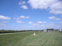
Latest photo of Tommy's Airpark Airport (9LL5)
-
 by Bill Schneider
Location & QuickFacts
| FAA Information Effective: | 2013-12-12 |
| Airport Identifier: | 9LL5 |
| Airport Status: | Operational |
| Longitude/Latitude: | 089-27-31.0000W/39-39-04.0000N
-89.458611/39.651111 (Estimated) |
| Elevation: | 595 ft / 181.36 m (Estimated) |
| Land: | 0 acres |
| From nearest city: | 3 nautical miles W of Edinburg, IL |
| Location: | Christian County, IL |
| Magnetic Variation: | 01W (2000) |
Owner & Manager
| Ownership: | Privately owned |
| Owner: | Thomas E. Georges |
| Address: | 425 E 2050 North Rd
Edinburg, IL 62531 |
| Phone number: | 217-623-5772 |
| Manager: | Thomas E. Georges |
| Address: | 425 E 2050 North Rd
Edinburg, IL 62531 |
| Phone number: | 217-623-5772 |
Airport Operations and Facilities
| Airport Use: | Private |
| Segmented Circle: | No |
| Control Tower: | No |
| Sectional chart: | St Louis |
| Region: | AGL - Great Lakes |
| Boundary ARTCC: | ZKC - Kansas City |
| Tie-in FSS: | STL - Saint Louis |
| FSS Toll Free: | 1-800-WX-BRIEF |
Runway Information
Runway 18/36
| Dimension: | 2200 x 100 ft / 670.6 x 30.5 m |
| Surface: | TURF, |
| |
Runway 18 |
Runway 36 |
| Traffic Pattern: | Left | Left |
| Obstruction: | | 25 ft pline, 120.0 ft from runway |
Radio Navigation Aids
| ID |
Type |
Name |
Ch |
Freq |
Var |
Dist |
| TAZ | NDB | Taylorville | | 395.00 | 00E | 9.3 nm |
| SP | NDB | Huskk | | 382.00 | 01W | 15.7 nm |
| LQ | NDB | Licol | | 375.00 | 01W | 17.0 nm |
| LTD | NDB | Litchfield | | 371.00 | 01E | 30.9 nm |
| AAA | NDB | Abraham | | 329.00 | 00E | 31.1 nm |
| SYZ | NDB | Shelbyville | | 365.00 | 01E | 32.1 nm |
| IJX | VOR/DME | Jacksonville | 023X | 108.60 | 02E | 36.8 nm |
| SPI | VORTAC | Spinner | 74X | 112.70 | 01W | 15.2 nm |
| CAP | VORTAC | Capital | 074X | 112.70 | 04E | 16.4 nm |
| DEC | VORTAC | Decatur | 119X | 117.20 | 03E | 28.3 nm |
| VLA | VORTAC | Vandalia | 090X | 114.30 | 04E | 36.2 nm |