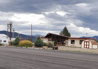
Latest photo of Harriet Alexander Field Airport (ANK)
-
 by Jack Poelstra
Location & QuickFacts
| FAA Information Effective: | 2013-12-12 |
| Airport Identifier: | ANK |
| Airport Status: | Operational |
| Longitude/Latitude: | 106-02-55.1000W/38-32-17.8000N
-106.048639/38.538278 (Estimated) |
| Elevation: | 7523 ft / 2293.01 m (Surveyed) |
| Land: | 161 acres |
| From nearest city: | 2 nautical miles W of Salida, CO |
| Location: | Chaffee County, CO |
| Magnetic Variation: | 09E (2010) |
Owner & Manager
| Ownership: | Publicly owned |
| Owner: | City Of Salida/chaffee County
COUNTY CONTACT: ROBERT CHRISTIANSEN |
| Address: | County Courthouse
Salida, CO 81201 |
| Phone number: | 719-539-2218 |
| Manager: | Carl Hasselbrink |
| Address: | 9255 County Road 140
Salida, CO 81201 |
| Phone number: | 719-539-3720 |
Airport Operations and Facilities
| Airport Use: | Open to public |
| Wind indicator: | Yes |
| Segmented Circle: | Yes |
| Control Tower: | No |
| Lighting Schedule: | SEE RMK
ACTVT MIRL RY 06/24 & PAPI RY 6 AND RY 24 - CTAF. |
| Beacon Color: | Clear-Green (lighted land airport) |
| Landing fee charge: | No |
| Sectional chart: | Denver |
| Region: | ANM - Northwest Mountain |
| Boundary ARTCC: | ZDV - Denver |
| Tie-in FSS: | DEN - Denver |
| FSS on Airport: | No |
| FSS Toll Free: | 1-800-WX-BRIEF |
| NOTAMs Facility: | DEN (NOTAM-d service avaliable) |
| Federal Agreements: | NGY |
Airport Communications
| CTAF: | 122.700 |
| Unicom: | 122.700 |
Airport Services
| Fuel available: | 100LLA
FUEL AVBL WITH CREDIT CARD. |
| Bottled Oxygen: | NONE |
Runway Information
Runway 06/24
| Dimension: | 7348 x 75 ft / 2239.7 x 22.9 m |
| Surface: | ASPH, Good Condition |
| Weight Limit: | Single wheel: 30000 lbs.
Dual wheel: 60000 lbs. |
| Edge Lights: | Medium |
| |
Runway 06 |
Runway 24 |
| Longitude: | 106-03-38.6642W | 106-02-11.4565W |
| Latitude: | 38-32-05.8011N | 38-32-29.8523N |
| Elevation: | 7523.00 ft | 7385.00 ft |
| Alignment: | 70 | 127 |
| Traffic Pattern: | Left | Left |
| Markings: | Basic, Fair Condition | Basic, Fair Condition |
| Crossing Height: | 35.00 ft | 44.00 ft |
| VASI: | 2-light PAPI on left side | 2-light PAPI on left side |
| Visual Glide Angle: | 3.50° | 3.00° |
| Obstruction: | 18 ft fence, 607.0 ft from runway, 1 ft left of centerline, 22:1 slope to clear | , 50:1 slope to clear |
Helipad H1
| Dimension: | 36 x 36 ft / 11.0 x 11.0 m |
| Surface: | CONC, Good Condition |
| |
Runway H1 |
Runway |
| Traffic Pattern: | Left | Left |
Radio Navigation Aids
| ID |
Type |
Name |
Ch |
Freq |
Var |
Dist |
| HBU | VOR/DME | Blue Mesa | 096X | 114.90 | 14E | 46.9 nm |