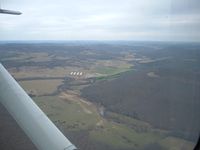
Latest photo of Lollars Creek Farm Airport (AR27)
-
 by Nathan Combs
Location & QuickFacts
| FAA Information Effective: | 2013-12-12 |
| Airport Identifier: | AR27 |
| Airport Status: | Operational |
| Longitude/Latitude: | 093-50-44.7000W/35-56-20.2820N
-93.845750/35.938967 (Estimated) |
| Elevation: | 1430 ft / 435.86 m (Estimated) |
| Land: | 0 acres |
| From nearest city: | 7 nautical miles SE of Wesley, AR |
| Location: | Madison County, AR |
| Magnetic Variation: | 05E (1985) |
Owner & Manager
| Ownership: | Privately owned |
| Owner: | Lollars Creek Farm, Inc. |
| Address: | Hcr 61, Box 418
Elkins, AR 72727 |
| Phone number: | 501-456-2500 |
| Manager: | David Ingie |
| Address: | Hcr 61, Box 412
Elkins, AR 72727 |
| Phone number: | 501-456-2500 |
Airport Operations and Facilities
| Airport Use: | Private |
| Wind indicator: | Yes |
| Segmented Circle: | No |
| Control Tower: | No |
| Landing fee charge: | No |
| Sectional chart: | Memphis |
| Region: | ASW - Southwest |
| Boundary ARTCC: | ZME - Memphis |
| Tie-in FSS: | JBR - Jonesboro |
| FSS on Airport: | No |
| FSS Toll Free: | 1-800-WX-BRIEF |
Runway Information
Runway 16/34
| Dimension: | 2100 x 45 ft / 640.1 x 13.7 m |
| Surface: | TURF, |
| |
Runway 16 |
Runway 34 |
| Traffic Pattern: | Right | Left |
| Obstruction: | 20 ft trees, 600.0 ft from runway | 30 ft trees, 400.0 ft from runway |
Radio Navigation Aids
| ID |
Type |
Name |
Ch |
Freq |
Var |
Dist |
| SLG | NDB | Siloam Springs | | 284.00 | 04E | 34.7 nm |
| CZE | NDB | Clarksville | | 201.00 | 04E | 35.0 nm |
| DAK | VOR/DME | Drake | 025X | 108.80 | 07E | 18.2 nm |
| HRO | VOR/DME | Harrison | 072X | 112.50 | 04E | 38.2 nm |
| RZC | VORTAC | Razorback | 111X | 116.40 | 04E | 22.8 nm |
| FSM | VORTAC | Fort Smith | 041X | 110.40 | 07E | 39.1 nm |