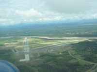
Latest photo of Allen Aaf Airport (BIG)
-
 by Mike Wallette
Location & QuickFacts
| FAA Information Effective: | 2013-12-12 |
| Airport Identifier: | BIG |
| Airport Status: | Operational |
| Longitude/Latitude: | 145-43-12.0888W/63-59-42.5771N
-145.720025/63.995160 (Estimated) |
| Elevation: | 1291 ft / 393.50 m (Surveyed) |
| Land: | 0 acres |
| From nearest city: | 3 nautical miles S of Delta Junction Ft Greely, AK |
| Location: | Fairbanks North Star County, AK |
| Magnetic Variation: | 23E (2005) |
Owner & Manager
| Ownership: | Army owned |
| Owner: | U.s. Army |
| Address: | U.s. Army Forces Command
Atlanta, GA |
| Manager: | Hq 172 Infantry Brigade |
| Address: | Ft Richardson
Alaska 99505 |
| Phone number: | 907-873-4171 |
Airport Operations and Facilities
| Airport Use: | Private |
| Wind indicator: | Yes |
| Segmented Circle: | Yes |
| Control Tower: | Yes |
| Lighting Schedule: | SEE RMK
ACTVT HIRL RYS 01/19 AND 10/28 & MIRL RY 07/25, PAPI RYS 01, 19 , 10 & 28 -CTAF. |
| Beacon Color: | Clear-Green (lighted land airport) |
| Landing fee charge: | No |
| Sectional chart: | Anchorage |
| Region: | AAL - Alaska |
| Boundary ARTCC: | ZAN - Anchorage |
| Tie-in FSS: | FAI - Fairbanks |
| FSS on Airport: | No |
| FSS Phone: | 907-474-0137 |
| FSS Toll Free: | 1-866-248-6516 |
| NOTAMs Facility: | BIG (NOTAM-d service avaliable) |
Airport Services
| Airframe Repair: | NONE |
| Power Plant Repair: | NONE |
| Bottled Oxygen: | NONE |
| Bulk Oxygen: | NONE |
Runway Information
Runway 01/19
| Dimension: | 9000 x 150 ft / 2743.2 x 45.7 m |
| Surface: | ASPH, Good Condition |
| Pavement Class: | 57 /F/A/W/T |
| Edge Lights: | High |
| |
Runway 01 |
Runway 19 |
| Longitude: | 145-44-06.6116W | 145-42-26.4703W |
| Latitude: | 63-59-10.9387N | 64-00-27.8442N |
| Elevation: | 1291.00 ft | 1225.00 ft |
| Alignment: | 30 | 127 |
| Traffic Pattern: | Left | Right |
| Markings: | Non-precision instrument, Good Condition | Non-precision instrument, Good Condition |
| Crossing Height: | 74.00 ft | 74.00 ft |
| Displaced threshold: | 1000.00 ft | 1000.00 ft |
| VASI: | 4-light PAPI on left side | 4-light PAPI on left side |
| Visual Glide Angle: | 3.00° | 3.00° |
Runway 07/25
| Dimension: | 4077 x 90 ft / 1242.7 x 27.4 m |
| Surface: | ASPH, Good Condition |
| Pavement Class: | 41 /F/A/W/T |
| Edge Lights: | Medium |
| |
Runway 07 |
Runway 25 |
| Longitude: | 145-43-49.2450W | 145-42-17.9160W |
| Latitude: | 63-59-29.3030N | 63-59-27.8370N |
| Elevation: | 1274.00 ft | 1262.00 ft |
| Alignment: | 92 | 127 |
| Traffic Pattern: | Left | Right |
| Markings: | Non-precision instrument, Good Condition | Non-precision instrument, Good Condition |
Runway 10/28
| Dimension: | 6115 x 150 ft / 1863.9 x 45.7 m |
| Surface: | ASPH, Good Condition |
| Pavement Class: | 65 /F/A/W/T |
| Edge Lights: | High |
| |
Runway 10 |
Runway 28 |
| Longitude: | 145-44-07.6453W | 145-42-14.7718W |
| Latitude: | 63-59-58.9685N | 63-59-24.8047N |
| Elevation: | 1254.00 ft | 1262.00 ft |
| Alignment: | 125 | 127 |
| ILS Type: | ILS/DME
| |
| Traffic Pattern: | Left | Left |
| Markings: | Precision instrument, Good Condition | Precision instrument, Good Condition |
| Crossing Height: | 76.00 ft | 74.00 ft |
| VASI: | 4-light PAPI on left side | 4-light PAPI on left side |
| Visual Glide Angle: | 3.00° | 3.00° |
| Runway End Identifier: | Yes | Yes |
Radio Navigation Aids
| ID |
Type |
Name |
Ch |
Freq |
Var |
Dist |
| DJN | NDB | Delta Junction | | 347.00 | 29E | 1.9 nm |
| BIG | VORTAC | Big Delta | 096X | 114.90 | 29E | 0.6 nm |