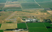
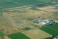
Latest photos of Franklin Field Airport (F72)
-
 by S B J
-
 by Ken Freeze
-
 by Ken Freeze
Location & QuickFacts
| FAA Information Effective: | 2013-12-12 |
| Airport Identifier: | F72 |
| Airport Status: | Operational |
| Longitude/Latitude: | 121-25-45.5000W/38-18-14.4000N
-121.429306/38.304000 (Estimated) |
| Elevation: | 23 ft / 7.01 m (Surveyed) |
| Land: | 496 acres |
| From nearest city: | 4 nautical miles SE of Franklin, CA |
| Location: | Sacramento County, CA |
| Magnetic Variation: | 16E (1985) |
Owner & Manager
| Ownership: | Publicly owned |
| Owner: | Sacramento County |
| Address: | 6151 Freeport Blvd
Sacramento, CA 95822-3518 |
| Phone number: | 916-875-9035 |
| Manager: | John Downey
OFFICE AT SACRAMENTO EXECUTIVE AIRPORT. |
| Address: | 6151 Freeport Blvd, Suite 177
Sacramento, CA 95822-3518 |
| Phone number: | 916-875-9035
SACRAMENTO EXECUTIVE AIRPORT. |
Airport Operations and Facilities
| Airport Use: | Open to public |
| Wind indicator: | Yes |
| Segmented Circle: | Yes |
| Control Tower: | No |
| Landing fee charge: | No |
| Sectional chart: | San Francisco |
| Region: | AWP - Western-Pacific |
| Traffic Pattern Alt: | 1000 ft |
| Boundary ARTCC: | ZOA - Oakland |
| Tie-in FSS: | RIU - Rancho Murieta |
| FSS on Airport: | No |
| FSS Toll Free: | 1-800-WX-BRIEF |
| NOTAMs Facility: | RIU (NOTAM-d service avaliable) |
| Federal Agreements: | NGY |
Airport Services
| Airframe Repair: | NONE |
| Power Plant Repair: | NONE |
| Bottled Oxygen: | NONE |
| Bulk Oxygen: | NONE |
Runway Information
Runway 09/27
| Dimension: | 3031 x 60 ft / 923.8 x 18.3 m |
| Surface: | ASPH, Good Condition |
| Weight Limit: | Single wheel: 30000 lbs. |
| |
Runway 09 |
Runway 27 |
| Longitude: | 121-26-04.5064W | 121-25-27.6606W |
| Latitude: | 38-18-09.4485N | 38-18-02.0722N |
| Elevation: | 19.00 ft | 22.00 ft |
| Alignment: | 104 | 127 |
| Traffic Pattern: | Right | Left |
| Markings: | Basic, Good Condition | Basic, Good Condition |
| Runway End Identifier: | | No |
| Centerline Lights: | | No |
| Touchdown Lights: | | No |
Runway 18/36
| Dimension: | 3123 x 60 ft / 951.9 x 18.3 m |
| Surface: | ASPH, Good Condition |
| Weight Limit: | Single wheel: 30000 lbs. |
| |
Runway 18 |
Runway 36 |
| Longitude: | 121-25-40.1089W | 121-25-49.6873W |
| Latitude: | 38-18-37.7757N | 38-18-07.8454N |
| Elevation: | 23.00 ft | 21.00 ft |
| Alignment: | 127 | 14 |
| Traffic Pattern: | Left | Right |
| Markings: | Basic, Good Condition | Basic, Good Condition |
Radio Navigation Aids
| ID |
Type |
Name |
Ch |
Freq |
Var |
Dist |
| TCY | NDB | Tracy | | 203.00 | 15E | 36.8 nm |
| LV | NDB | Reiga | | 374.00 | 16E | 38.7 nm |
| SUU | TACAN | Travis | 113X | | 17E | 24.6 nm |
| BAB | TACAN | Beale | 023X | | 16E | 49.9 nm |
| TZZ | VOR | Travis | | 116.40 | 17E | 18.1 nm |
| MCC | VOR/DME | Mc Clellan | 029X | 109.20 | 17E | 21.9 nm |
| CCR | VOR/DME | Concord | 117X | 117.00 | 17E | 33.0 nm |
| HNW | VOR/DME | Hangtown | 102X | 115.50 | 17E | 40.8 nm |
| MOD | VOR/DME | Modesto | 093X | 114.60 | 17E | 46.4 nm |
| MYV | VOR/DME | Marysville | 045X | 110.80 | 16E | 48.2 nm |
| SAC | VORTAC | Sacramento | 099X | 115.20 | 17E | 10.2 nm |
| LIN | VORTAC | Linden | 095X | 114.80 | 17E | 24.4 nm |
| ECA | VORTAC | Manteca | 107X | 116.00 | 17E | 30.8 nm |
| SGD | VORTAC | Scaggs Island | 058X | 112.10 | 17E | 45.2 nm |
| SAC | VOT | Sacramento Executive | | 111.40 | | 13.0 nm |
| SMF | VOT | Sacramento Metropolitan | | 111.40 | | 24.4 nm |