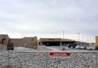
Latest photo of St Vincent Hospital Heliport (NM06)
-
 by Zane Adams
Location & QuickFacts
| FAA Information Effective: | 2013-12-12 |
| Airport Identifier: | NM06 |
| Airport Status: | Operational |
| Longitude/Latitude: | 105-56-44.0760W/35-39-34.1130N
-105.945577/35.659476 (Estimated) |
| Elevation: | 7012 ft / 2137.26 m (Estimated) |
| Land: | 0 acres |
| From nearest city: | 2 nautical miles S of Santa Fe, NM |
| Location: | Santa Fe County, NM |
| Magnetic Variation: | 11E (1985) |
Owner & Manager
| Ownership: | Privately owned |
| Owner: | St Vincent Hospital |
| Address: | 455 St Michael's Dr Box 2107
Santa Fe, NM 87501 |
| Phone number: | 505-983-3361 |
| Manager: | Max S. Roy |
| Address: | 455 St. Michaels Drive
Santa Fe, NM 87501 |
| Phone number: | 505-820-5386 |
Airport Operations and Facilities
| Airport Use: | Private
MEDICAL. |
| Wind indicator: | Yes |
| Segmented Circle: | Yes |
| Control Tower: | No |
| Landing fee charge: | No |
| Sectional chart: | Albuquerque |
| Region: | ASW - Southwest |
| Boundary ARTCC: | ZAB - Albuquerque |
| Tie-in FSS: | ABQ - Albuquerque |
| FSS on Airport: | No |
| FSS Toll Free: | 1-800-WX-BRIEF |
Runway Information
Helipad H1
| Dimension: | 68 x 68 ft / 20.7 x 20.7 m |
| Surface: | ASPH, |
| |
Runway H1 |
Runway |
| Traffic Pattern: | Left | Left |
Radio Navigation Aids
| ID |
Type |
Name |
Ch |
Freq |
Var |
Dist |
| SKX | NDB | Ski | | 414.00 | 11E | 49.7 nm |
| OTO | VOR | Otto | | 114.00 | 13E | 35.3 nm |
| SAF | VORTAC | Santa Fe | 043X | 110.60 | 13E | 9.2 nm |
| FTI | VORTAC | Fort Union | 120X | 117.30 | 13E | 39.6 nm |
| ABQ | VOT | Albuquerque Intl | | 111.00 | | 49.3 nm |