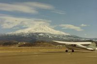
Latest photo of Weed Airport (O46)
-
 by S B J
Location & QuickFacts
| FAA Information Effective: | 2013-12-12 |
| Airport Identifier: | O46 |
| Airport Status: | Operational |
| Longitude/Latitude: | 122-27-16.3000W/41-28-50.9000N
-122.454528/41.480806 (Estimated) |
| Elevation: | 2943 ft / 897.03 m (Surveyed) |
| Land: | 344 acres |
| From nearest city: | 4 nautical miles NW of Weed, CA |
| Location: | Siskiyou County, CA |
| Magnetic Variation: | 18E (1985) |
Owner & Manager
| Ownership: | Publicly owned |
| Owner: | County Of Siskiyou |
| Address: | 411 4th Street
Yreka, CA 96097 |
| Phone number: | 530-842-8295 |
| Manager: | Melissa Cummins
DIRECTOR OF AIRPORTS OFFICE IN YREKA. |
| Address: | 411 4th Street
Yreka, CA 96097 |
| Phone number: | 530-842-8295
PHONE RINGS AT COUNTY AIRPORT OFFICE - YREKA |
Airport Operations and Facilities
| Airport Use: | Open to public |
| Wind indicator: | Yes |
| Segmented Circle: | Yes |
| Control Tower: | No |
| Lighting Schedule: | SEE RMK
ACTVT MIRL RY 14/32 - CTAF. |
| Beacon Color: | Clear-Green (lighted land airport) |
| Landing fee charge: | Yes |
| Sectional chart: | Klamath Falls |
| Region: | AWP - Western-Pacific |
| Traffic Pattern Alt: | 1000 ft |
| Boundary ARTCC: | ZSE - Seattle |
| Tie-in FSS: | RIU - Rancho Murieta |
| FSS on Airport: | No |
| FSS Toll Free: | 1-800-WX-BRIEF |
| NOTAMs Facility: | RIU (NOTAM-d service avaliable) |
| Federal Agreements: | NGSY |
Airport Communications
| CTAF: | 122.700 |
| Unicom: | 122.700 |
Airport Services
| Fuel available: | 100LLA |
| Airframe Repair: | NONE |
| Power Plant Repair: | NONE |
| Bottled Oxygen: | NONE |
| Bulk Oxygen: | NONE |
Runway Information
Runway 14/32
| Dimension: | 5000 x 60 ft / 1524.0 x 18.3 m |
| Surface: | ASPH, Fair Condition |
| Surface Treatment: | Aggregate Friction Seal Coat |
| Weight Limit: | Single wheel: 12000 lbs. |
| Edge Lights: | Medium |
| |
Runway 14 |
Runway 32 |
| Longitude: | 122-27-28.6455W | 122-27-03.9766W |
| Latitude: | 41-29-13.7364N | 41-28-27.9795N |
| Elevation: | 2907.00 ft | 2943.00 ft |
| Traffic Pattern: | Right | Left |
| Markings: | Basic, Fair Condition | Basic, Fair Condition |
| Crossing Height: | 23.00 ft | 20.00 ft |
| VASI: | 2-box on left side | 2-box on left side |
| Visual Glide Angle: | 3.00° | 3.00° |
| Runway End Identifier: | No | No |
| Centerline Lights: | No | No |
| Touchdown Lights: | No | No |
| Obstruction: | , 50:1 slope to clear | 15 ft road, 900.0 ft from runway, 46:1 slope to clear |
Radio Navigation Aids
| ID |
Type |
Name |
Ch |
Freq |
Var |
Dist |
| MOG | NDB | Montague | | 404.00 | 19E | 14.9 nm |
| LFA | NDB | Merrill | | 347.00 | 17E | 47.4 nm |
| FJS | VOR/DME | Fort Jones | 033X | 109.60 | 19E | 16.0 nm |