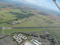
Latest photos of RAF Wyton
-
 by magnaman
-
 by chris hall
Location & QuickFacts
| Airport ICAO Code: | EGUY |
| Airport IATA Code: | QUY |
| Longitude/Latitude: | W 000° 06' 28.20"/N 52° 21' 25.80"
-0.107833/52.357167 |
| Elevation: | 135 ft / 41.15 m |
| Location: | St Ives, England, United Kingdom |
| Magnetic Variation: | W 2°05.2' (2008-04) |
| Time Zone: | UTC 0(+1DT) |
Airport Communications
| Type |
Name |
Freq 1 |
Freq 2 |
Freq 3 |
Freq 4 |
Freq 5 |
| Approach Control | APP | 134.05 M | 369.525 M | | | |
| Automatic Terminal Information Service | ATIS | 279.15 M | | | | |
| Ground Control | GND | 122.1 M | 278.35 M | | | |
| Tower | TWR | 119.975 M | 372.2 M | | | |
Runway Information
Runway 09/27
| Dimension: | 8254 x 200 ft / 2515.8 x 61.0 m |
| Surface: | Asphalt, asphaltic concrete, tar macadam, or bitumen bound macadam. |
| |
Runway 09 |
Runway 27 |
| Longitude: | -0.126333 / W 000° 07' 34.80" | -0.089556 / W 000° 05' 22.40" |
| Latitude: | 52.355694 / N 52° 21' 20.50" | 52.358556 / N 52° 21' 30.80" |
| End Elevation: | 134.0 ft | 104.0 ft |
| Alignment: | 085.0 | 265.0 |
| Slope: | -0.4 | 0.4 |
| Touchdown Zone Elev.: | Unknown | Unknown |
Runway 15/33
| Dimension: | 3465 x 59 ft / 1056.1 x 18.0 m |
| Surface: | Asphalt, asphaltic concrete, tar macadam, or bitumen bound macadam. |
| |
Runway 15 |
Runway 33 |
| Longitude: | -0.115833 / W 000° 06' 57.00" | -0.108194 / W 000° 06' 29.50" |
| Latitude: | 52.360861 / N 52° 21' 39.10" | 52.352417 / N 52° 21' 08.70" |
| End Elevation: | 129.0 ft | 126.0 ft |
| Alignment: | 154.0 | 334.0 |
| Slope: | -0.1 | 0.1 |
| Touchdown Zone Elev.: | 130.0 | 130.0 |