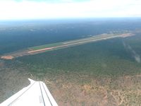
Latest photo of Victoria Falls Airport
-
 by Paul H
Location & QuickFacts
| Airport ICAO Code: | FVFA |
| Airport IATA Code: | VFA |
| Airport Type: | A - Civil |
| Longitude/Latitude: | E 025° 50' 20.42"/S 18° 05' 45.17"
25.839006/-18.095881 |
| Elevation: | 3490 ft / 1063.75 m |
| Location: | Victoria Falls, Zimbabwe |
| Magnetic Variation: | W 8°05.7' (2008-04) |
| Time Zone: | UTC+2 |
Airport Communications
| Type |
Name |
Freq 1 |
Freq 2 |
Freq 3 |
Freq 4 |
Freq 5 |
| Approach Control | FALLS APP | 121.1 M | | | | |
| Tower | FALLS TWR | 121.1 M | | | | |
Runway Information
Runway 12/30
| Dimension: | 7708 x 98 ft / 2349.4 x 29.9 m |
| Surface: | Asphalt, asphaltic concrete, tar macadam, or bitumen bound macadam. |
| |
Runway 12 |
Runway 30 |
| Longitude: | 25.828581 / E 025° 49' 42.89" | 25.849428 / E 025° 50' 57.94" |
| Latitude: | -18.092236 / S 18° 05' 32.05" | -18.099525 / S 18° 05' 58.29" |
| End Elevation: | 3490.0 ft | 3480.0 ft |
| Alignment: | 118.0 | 298.0 |
| Slope: | -0.1 | 0.1 |
| Touchdown Zone Elev.: | Unknown | Unknown |
| Lighting System 1: | ALSF-1 | Lights |
| Lighting System 2: | PAPI - Precision Approach Path Indicator | |
| Lighting System 3: | Lights | |