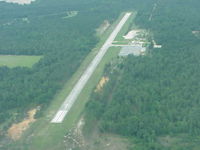
Latest photo of Sylvester Airport (SYV)
-
 by Michael Martin
Location & QuickFacts
| FAA Information Effective: | 2013-12-12 |
| Airport Identifier: | SYV |
| Airport Status: | Operational |
| Longitude/Latitude: | 083-53-39.0000W/31-33-23.0000N
-83.894167/31.556389 (Estimated) |
| Elevation: | 403 ft / 122.83 m (Surveyed) |
| Land: | 70 acres |
| From nearest city: | 3 nautical miles NW of Sylvester, GA |
| Location: | Worth County, GA |
| Magnetic Variation: | 02W (1985) |
Owner & Manager
| Ownership: | Publicly owned |
| Owner: | City Of Sylvester |
| Address: | 101 North Main Street
Sylvester, GA 31791 |
| Phone number: | 229-776-8505 |
| Manager: | Tommy Bozeman |
| Address: | 101 North Main Street
Sylvester, GA 31791 |
| Phone number: | 229-776-8505 |
Airport Operations and Facilities
| Airport Use: | Open to public |
| Wind indicator: | Yes |
| Segmented Circle: | Yes |
| Control Tower: | No |
| Lighting Schedule: | SEE RMK
DUSK-DAWN. ACTVT MIRL RY 01/19 AND PAPI RYS 01 & 19 - CTAF. |
| Beacon Color: | Clear-Green (lighted land airport) |
| Landing fee charge: | No |
| Sectional chart: | Jacksonville |
| Region: | ASO - Southern |
| Boundary ARTCC: | ZJX - Jacksonville |
| Tie-in FSS: | MCN - Macon |
| FSS on Airport: | No |
| FSS Toll Free: | 1-800-WX-BRIEF |
| NOTAMs Facility: | MCN (NOTAM-d service avaliable) |
| Federal Agreements: | NY1 |
Airport Communications
| CTAF: | 122.800 |
| Unicom: | 122.800 |
Airport Services
| Airframe Repair: | NONE |
| Power Plant Repair: | NONE |
| Bottled Oxygen: | NONE |
| Bulk Oxygen: | NONE |
Runway Information
Runway 01/19
| Dimension: | 3293 x 75 ft / 1003.7 x 22.9 m
55 FT BLAST PAD RY 19 END. |
| Surface: | ASPH, Good Condition |
| Weight Limit: | Single wheel: 26000 lbs. |
| Edge Lights: | Medium |
| |
Runway 01 |
Runway 19 |
| Longitude: | 083-53-42.0700W | 083-53-35.8600W |
| Latitude: | 31-33-06.9500N | 31-33-39.1100N |
| Elevation: | 393.00 ft | 393.00 ft |
| Traffic Pattern: | Left | Left |
| Markings: | Basic, Poor Condition
RY 01/19 MARKINGS BADLY FADED. | Basic, Poor Condition |
| VASI: | 2-light PAPI on left side | 2-light PAPI on left side |
| Obstruction: | , 50:1 slope to clear | 20 ft trees, 600.0 ft from runway, 150 ft right of centerline, 20:1 slope to clear |
Radio Navigation Aids
| ID |
Type |
Name |
Ch |
Freq |
Var |
Dist |
| AB | NDB | Putny | | 227.00 | 02W | 20.5 nm |
| TM | NDB | Tifto | | 409.00 | 03W | 25.8 nm |
| OHY | NDB | Coney | | 400.00 | 02W | 26.6 nm |
| CXU | NDB | Camilla | | 369.00 | 02W | 27.0 nm |
| SUR | NDB | Fitzgerald | | 362.00 | 03W | 31.1 nm |
| GTP | NDB | Patten | | 245.00 | 02W | 36.2 nm |
| LKG | NDB | Lindbergh | | 242.00 | 03W | 38.7 nm |
| CYR | NDB | Caidy | | 338.00 | 01W | 42.4 nm |
| IWJ | NDB | Blaak | | 344.00 | 03W | 47.8 nm |
| LYZ | NDB | Willis | | 359.00 | 01W | 47.8 nm |
| IZS | NDB | Montezuma | | 426.00 | 04W | 49.1 nm |
| IFM | VOR | Tift Myers | | 112.50 | 01W | 22.1 nm |
| MGR | VOR/DME | Moultrie | 025X | 108.80 | 02W | 28.9 nm |
| PZD | VORTAC | Pecan | 108X | 116.10 | 02W | 21.3 nm |
| VNA | VORTAC | Vienna | 112X | 116.50 | 01E | 44.4 nm |