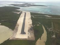
Latest photo of Duncan Town Airport
-
 by Christian F Rouleau DMD, MD
Location & QuickFacts
| Airport ICAO Code: | MYRD |
| Airport IATA Code: | DCT |
| Longitude/Latitude: | W 075° 43' 46.04"/N 22° 10' 54.49"
-75.729456/22.181803 |
| Elevation: | 6 ft / 1.83 m |
| Location: | Duncan Town, Ragged Island, Bahamas |
| Magnetic Variation: | W 7°52.1' (2008-04) |
| Time Zone: | UTC-5(-4DT) |
Airport Communications
| Type |
Name |
Freq 1 |
Freq 2 |
Freq 3 |
Freq 4 |
Freq 5 |
| Unicom Or CTAF/Unicom | UNICOM | 122.8 M | | | | |
Runway Information
Runway 13/31
| Dimension: | 3800 x 75 ft / 1158.2 x 22.9 m |
| Surface: | Asphalt, asphaltic concrete, tar macadam, or bitumen bound macadam. |
| |
Runway 13 |
Runway 31 |
| Longitude: | -75.733781 / W 075° 44' 01.61" | -75.725131 / W 075° 43' 30.47" |
| Latitude: | 22.185150 / N 22° 11' 06.54" | 22.178456 / N 22° 10' 42.44" |
| Alignment: | 137.0 | 317.0 |
| Slope: | Unknown | Unknown |
| Touchdown Zone Elev.: | Unknown | Unknown |
| Lighting System 1: | High Intensity Runway Lights | High Intensity Runway Lights |