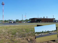
Latest photos of Aviador Carlos Campos Airport
-
 by Tigerland
-
 by Carolina Resource Mapping
Location & QuickFacts
| Airport ICAO Code: | SAZY |
| Airport IATA Code: | CPC |
| Longitude/Latitude: | W 071° 08' 14.26"/S 40° 04' 31.38"
-71.137294/-40.075383 |
| Elevation: | 2569 ft / 783.03 m |
| Location: | San Martín de los Andes, Neuquén Province, Argentina |
| Magnetic Variation: | E 7°09.5' (2008-04) |
| Time Zone: | UTC-3 |
Airport Communications
| Type |
Name |
Freq 1 |
Freq 2 |
Freq 3 |
Freq 4 |
Freq 5 |
| Ground Control | GND | 121.7 M | | | | |
| Tower | CHAPELCO APP/TWR | 119.6 M | 118.2 M | | | |
Runway Information
Runway 06/24
| Dimension: | 8202 x 147 ft / 2500.0 x 44.8 m |
| Surface: | Asphalt, asphaltic concrete, tar macadam, or bitumen bound macadam. |
| |
Runway 06 |
Runway 24 |
| Longitude: | -71.150942 / W 071° 09' 03.39" | -71.123647 / W 071° 07' 25.13" |
| Latitude: | -40.079578 / S 40° 04' 46.48" | -40.071189 / S 40° 04' 16.28" |
| End Elevation: | 2568.0 ft | 2526.0 ft |
| Alignment: | 061.0 | 240.0 |
| Slope: | -0.5 | 0.5 |
| Touchdown Zone Elev.: | Unknown | Unknown |