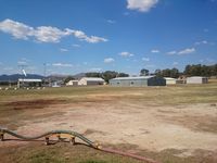
Latest photo of Tumut Airport
-
 by YSWG-photography
Location & QuickFacts
| Airport ICAO Code: | YTMU |
| Airport IATA Code: | TUM |
| Longitude/Latitude: | E 148° 14' 27.00"/S 35° 15' 46.00"
148.240833/-35.262778 |
| Elevation: | 878 ft / 267.61 m |
| Location: | Tumut, New South Wales, Australia |
| Magnetic Variation: | E 12°05.0' (2008-04) |
| Time Zone: | UTC+10(+11DT) |
Airport Communications
| Type |
Name |
Freq 1 |
Freq 2 |
Freq 3 |
Freq 4 |
Freq 5 |
| Common Traffic Advisory Frequency | CTAF | 126.7 M | | | | |
| Flight Service Station | MELBOURNE CNTR | 119.5 M | | | | |
Communication Remarks
- Flight Service Station - (circuit area)
Runway Information
Runway 17/35
| Dimension: | 3478 x 60 ft / 1060.1 x 18.3 m |
| Surface: | Asphalt, asphaltic concrete, tar macadam, or bitumen bound macadam. |
| |
Runway 17 |
Runway 35 |
| Longitude: | 148.240700 / E 148° 14' 26.52" | 148.240303 / E 148° 14' 25.09" |
| Latitude: | -35.263442 / S 35° 15' 48.39" | -35.272989 / S 35° 16' 22.76" |
| Alignment: | 170.0 | 350.0 |
| Slope: | Unknown | Unknown |
| Touchdown Zone Elev.: | Unknown | Unknown |