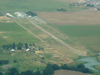
Latest photo of Flying J Ranch Airport (E37)
-
 by Ken Freeze
Location & QuickFacts
| FAA Information Effective: | 2013-12-12 |
| Airport Identifier: | E37 |
| Airport Status: | Operational |
| Longitude/Latitude: | 109-52-54.2930W/32-50-52.2360N
-109.881748/32.847843 (Estimated) |
| Elevation: | 3114 ft / 949.15 m (Estimated) |
| Land: | 280 acres |
| From nearest city: | 4 nautical miles SW of Pima, AZ |
| Location: | Graham County, AZ |
| Magnetic Variation: | 12E (1985) |
Owner & Manager
| Ownership: | Privately owned |
| Owner: | Howard E. Jenkins |
| Address: | 10727 West Cottonwood Road
Pima, AZ 85543 |
| Phone number: | 928-485-9201 |
| Manager: | Howard E. Jenkins |
| Address: | 10727 West Cottonwood Road
Pima, AZ 85543 |
| Phone number: | 928-485-9201 |
Airport Operations and Facilities
| Airport Use: | Open to public |
| Wind indicator: | Yes |
| Segmented Circle: | No |
| Control Tower: | No |
| Landing fee charge: | No |
| Sectional chart: | Phoenix |
| Region: | AWP - Western-Pacific |
| Boundary ARTCC: | ZAB - Albuquerque |
| Tie-in FSS: | PRC - Prescott |
| FSS on Airport: | No |
| FSS Toll Free: | 1-800-WX-BRIEF |
| NOTAMs Facility: | PRC (NOTAM-d service avaliable) |
Airport Services
| Airframe Repair: | NONE |
| Power Plant Repair: | NONE |
| Bottled Oxygen: | NONE |
| Bulk Oxygen: | NONE |
Runway Information
Runway 07/25
| Dimension: | 1650 x 48 ft / 502.9 x 14.6 m
RY 18/36 SOUTH 540 FT 45 FT WIDE; NORTH 240 FT 80 FT WIDE. |
| Surface: | DIRT, Good Condition
RY 18/36 NORTH 800 FT EXTREMELY ROUGH, RUTTED AND HAS LARGE ROCKS. |
| |
Runway 07 |
Runway 25 |
| Traffic Pattern: | Left | Left |
Runway 18/36
| Dimension: | 2950 x 45 ft / 899.2 x 13.7 m
RY 18/36 SOUTH 540 FT 45 FT WIDE; NORTH 240 FT 80 FT WIDE. |
| Surface: | DIRT, Poor Condition
RY 18/36 NORTH 800 FT EXTREMELY ROUGH, RUTTED AND HAS LARGE ROCKS. |
| |
Runway 18 |
Runway 36 |
| Traffic Pattern: | Left | Left |
| Obstruction: | 6 ft brush | 6 ft brush, 0.0 ft from runway |
Radio Navigation Aids
| ID |
Type |
Name |
Ch |
Freq |
Var |
Dist |
| GAZ | NDB | Globe | | 255.00 | 13E | 49.9 nm |
| SSO | VORTAC | San Simon | 101X | 115.40 | 13E | 46.8 nm |
| CIE | VORTAC | Cochise | 105X | 115.80 | 13E | 49.4 nm |