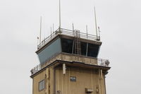
Oxnard Airport (OXR) Photo

Channel Islands Helicopters- scenic helicopter passenger flights
Photo Info
Airport Oxnard Airport
Photographer
Doug Robertson Contact
Shot Date 2011-12-04
Upload Date 2011-12-26
Views 811
EXIF Data
Camera Make Canon
Camera Model Canon PowerShot A720 IS
Shutter Speed 1/400 sec
Aperture f/4
ISO 80
Focal Length 11.5 mm
Exposure Bias 0 EV
Metering Mode Pattern
White Balance Auto
Dimensions 1600 × 1200
Date Taken 2011-12-04 14:30:09
More photos of Oxnard Airport
Total 52 photos. View all photos
OXR, Unusually occupied GA ramp because nearby Camarillo CMA's sole runway is closed for maintenance. CMA tower diverting aircraft to OXR with some CMA-based aircraft departing early to OXR before the closure, photo by Doug Robertson
Doug Robertson
OXR, Golden West FBO-on site of former Million Air FBO, photo by Doug Robertson
Doug Robertson
OXR, Oxnard, California FAA Control Tower OXR, School Canyon brushfire smoke North, photo by Doug Robertson
Doug Robertson
OXR, OXR Runway 07-25, 5,953' X 100' asphalt, Million Air Hangar Southeast end. OXR was a Civilian Pilot Training Program field from 1939 onward thru World War II. Mira Loma Academy pilot housing across Fifth Street south of field now low-cost rental housing., photo by Doug Robertson
Doug Robertson
OXR, OXR Aircraft Control Tower-Closeup. Runway Elevation-45'. Approach/Departure 124.7, ATIS 118.05, CTAF 134.95. Ground control 121.9, Tower 134.95 Rwy 07-25 5,953X100 paved, photo by Doug Robertson
Doug Robertson