Waterloo Regional Airport (ALO)
Waterloo Regional Airport (ALO)
ALO
Waterloo Regional Airport (ALO)
Waterloo, IA
Latest photos of Waterloo Regional Airport (ALO)
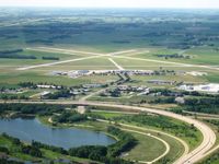
Ray Rich
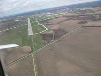
Ray Rich
| FAA Information Effective | 2026-07-09 |
| Airport Identifier | ALO |
| Airport Status | Operational |
| Longitude/Latitude |
92°24'3.6840"
W /
42°33'30.4170"
N -92.401023 / 42.558449 (Estimated) |
| Elevation | 873.00 ft / 266.09 m (Surveyed) |
| Land | 2583 acres |
| From nearest city | 4 nautical miles NW of Waterloo, IA |
| Location | Black Hawk County, IA |
| Airport Use | Open to public |
| Wind indicator | Yes |
| Segmented Circle | No |
| Control Tower | ATCT |
| Lighting Schedule | SEE RMK |
| Beacon Color | White-Green (lighted land airport) |
| Landing fee charge | No |
| Sectional chart | CHICAGO |
| Region | ACE - Central |
| Responsible ARTCC | ZMP - MINNEAPOLIS |
| Tie-in FSS | FOD - FORT DODGE |
| FSS on Airport | No |
| FSS Toll Free | 1-800-WX-BRIEF |
| NOTAMs Facility | ALO (NOTAM-d service available) |
| Certification type/date | 1973/05 |
Runway 12/30
| Dimensions | 8399 x 150 ft (2560 x 46 m) |
| Surface | ASPH (GOOD) |
| Surface treatment | Saw-cut or plastic Grooved |
| Edge lights | High |
| 12 | 30 | |
|---|---|---|
| Alignment | 128° | 308° |
| Physical elevation | 872.60 ft | 867.00 ft |
| Coordinates | 42.566036 / -92.411948 | 42.551915 / -92.387314 |
| Traffic pattern | Left | Left |
| Runway marking | Precision instrument , Good Condition | Non-precision instrument , Good Condition |
| ILS type | ILS/DME | |
| VGSI | 4-light PAPI on left | 4-box on left |
| RVR equipment | touchdown | rollout |
| Approach light | MALSR | MALS |
Runway 18/36
| Dimensions | 6003 x 150 ft (1830 x 46 m) |
| Surface | ASPH-CONC (GOOD) |
| Surface treatment | Saw-cut or plastic Grooved |
| Edge lights | Medium |
| 18 | 36 | |
|---|---|---|
| Alignment | 188° | 8° |
| Physical elevation | 870.80 ft | 868.00 ft |
| Coordinates | 42.565872 / -92.401465 | 42.549552 / -92.404481 |
| Traffic pattern | Left | Left |
| Runway marking | Non-precision instrument , Fair Condition | Non-precision instrument , Fair Condition |
| VGSI | 4-box on left | 4-light PAPI on left |
| Runway end lights | Yes | Yes |
- FOR CD IF UNA ON 121.9 CTC WATERLOO ATCT AT 319-233-4835. WHEN WATERLOO ATCT CLSD, FOR CD CTC MINNEAPOLIS ARTCC AT 651-463-5588.
- ACR NA TWY A EAST OF RWY 12/30.
- TWY A LGT BTN RWY 12/30 & ARMY AVN SUPPORT RAMP NA.
- BIRDS ON & INVOF ARPT.
- RWY 30 IS CALM WIND RWY.
- WHEN DEPARTING ALL RWYS, ENDS OF OTHER RWYS NOT VISIBLE.
- WHEN ATCT CLSD & DURG SNOW EVENTS, ALL ARR/DEP ACFT ANNC THEIR INTNS ON CTAF 5 MIN PRIOR TO USING THE RWYS.
- PERSONNEL & EQUP PERFORMING SNOW REMOVAL OPNS WILL MONITOR CTAF.
- ARNG: ARNG OPS CTC DSN 431-5520, C319-234-1372.
- ARPT SFC CONDS UNMON 2200-0430 DAILY.