Gainesville Regional Airport (GNV)
Gainesville Regional Airport (GNV)
GNV
Gainesville Regional Airport (GNV)
Gainesville, FL
Latest photos of Gainesville Regional Airport (GNV)
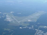
Bob Simmermon
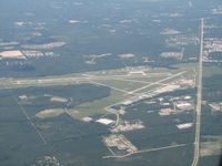
Sam Andrews
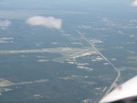
Sam Andrews
| FAA Information Effective | 2026-07-09 |
| Airport Identifier | GNV |
| Airport Status | Operational |
| Longitude/Latitude |
82°16'18.4000"
W /
29°41'24.2000"
N -82.271778 / 29.690056 (Estimated) |
| Elevation | 151.40 ft / 46.15 m (Surveyed) |
| Land | 1650 acres |
| From nearest city | 3 nautical miles NE of Gainesville, FL |
| Location | Alachua County, FL |
| Magnetic Variation | 04W (2005) |
| Airport Use | Open to public |
| Wind indicator | Yes |
| Segmented Circle | Yes |
| Control Tower | ATCT |
| Lighting Schedule | SEE RMK |
| Beacon Color | White-Green (lighted land airport) |
| Landing fee charge | No |
| Sectional chart | JACKSONVILLE |
| Region | ASO - Southern |
| Responsible ARTCC | ZJX - JACKSONVILLE |
| Tie-in FSS | GNV - GAINESVILLE |
| FSS on Airport | No |
| FSS Toll Free | 1-800-WX-BRIEF |
| NOTAMs Facility | GNV (NOTAM-d service available) |
| Certification type/date | 1973/05 |
Runway 07/25
| Dimensions | 4158 x 100 ft (1267 x 30 m) |
| Surface | ASPH (FAIR) |
| Surface treatment | Saw-cut or plastic Grooved |
| Edge lights | Medium |
| 07 | 25 | |
|---|---|---|
| Alignment | 61° | 241° |
| Physical elevation | 151.40 ft | 130.20 ft |
| Coordinates | 29.690306 / -82.282392 | 29.695844 / -82.270935 |
| Traffic pattern | Left | Left |
| Runway marking | Non-precision instrument , Good Condition | Non-precision instrument , Good Condition |
| VGSI | 4-light PAPI on left | 4-light PAPI on left |
| Runway end lights | No |
Runway 11/29
| Dimensions | 7504 x 150 ft (2287 x 46 m) |
| Surface | ASPH (GOOD) |
| Surface treatment | Saw-cut or plastic Grooved |
| Edge lights | High |
| 11 | 29 | |
|---|---|---|
| Alignment | 102° | 282° |
| Physical elevation | 147.40 ft | 105.10 ft |
| Coordinates | 29.690557 / -82.280599 | 29.686170 / -82.257508 |
| Traffic pattern | Left | Left |
| Runway marking | Precision instrument , Good Condition | Precision instrument , Good Condition |
| ILS type | ILS | |
| VGSI | 4-light PAPI on left | 4-light PAPI on right |
| RVR equipment | rollout | touchdown |
| Approach light | MALSR | |
| Runway end lights | Yes |
- WHEN ATCT CLSD ACFT MORE THAN 12500 LBS CTC FBO FOR PRKG INSTR PRIOR TO EXITING TWY A DUE TO IREG PAVEMENT STRENGTHS - 352-335-4681.
- GA RAMP LMTD TO ACFT 110,000 LB OR BLW; OTHERS PPR.
- BANNER TOWING NA EXC 72 HR PPR - AMGR.
- ARPT SFC COND NOT MNTD BTW 2330 - 0400 DLY.
- FOR CD IF UNA TO CTC ON FSS FREQ, CTC JACKSONVILLE APCH AT 904-741-0284.
- RWY 11-29 MRKGS ON W END ARE NOT STD DUE TO MRKGS NOT FULLY REMOVED/GHOSTING.
- TWY B LMTD TO 75,000 LB OR BLW; OTHERS PPR
- TWY C LMTD TO 120,000 LB OR BLW; OTHERS PPR
- TWY D LMTD TO 120,000 LB OR BLW; OTHERS PPR
- 24 HR PPR FOR ACFT EQUIPPED WITH WEATHER MODIFICATION OR GEOENGINEERING EQPT 352-262-6691.
- PORTIONS OF RWY 07/25 & NE 1000 FT OF TWY A NOT VSB FM ATCT; BLOCKED BY VORTAC BLDG.
- WILDLIFE ON & INVOF ARPT.