Billy Mitchell Airport (HSE)
Billy Mitchell Airport (HSE)
HSE
Billy Mitchell Airport (HSE)
Hatteras, NC
Latest photos of Billy Mitchell Airport (HSE)
scotch-canadian
Nigel Hay
| FAA Information Effective | 2026-07-09 |
| Airport Identifier | HSE |
| Airport Status | Operational |
| Longitude/Latitude |
75°37'4.1000"
W /
35°13'58.1000"
N -75.617806 / 35.232806 (Estimated) |
| Elevation | 16.30 ft / 4.97 m (Surveyed) |
| Land | 100 acres |
| From nearest city | 4 nautical miles E of Hatteras, NC |
| Location | Dare County, NC |
| Magnetic Variation | 10W (1995) |
| Airport Use | Open to public |
| Wind indicator | Yes |
| Segmented Circle | No |
| Control Tower | NON-ATCT |
| Landing fee charge | No |
| Sectional chart | CHARLOTTE |
| Region | ASO - Southern |
| Responsible ARTCC | ZDC - WASHINGTON |
| Tie-in FSS | RDU - RALEIGH |
| FSS on Airport | No |
| FSS Toll Free | 1-800-WX-BRIEF |
| NOTAMs Facility | HSE (NOTAM-d service available) |
Runway 07/25
| Dimensions | 3002 x 75 ft (915 x 23 m) |
| Surface | ASPH (FAIR) |
| Surface treatment |
| 07 | 25 | |
|---|---|---|
| Alignment | 57° | 237° |
| Physical elevation | 8.60 ft | 16.10 ft |
| Coordinates | 35.230530 / -75.621996 | 35.235056 / -75.613592 |
| Traffic pattern | Left | Left |
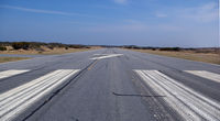
| Runway marking | Non-precision instrument , Good Condition | Non-precision instrument , Good Condition |
- +10-35 FT SAND DUNES AND SCRUB TREES BOTH SIDES OF RWY WITHIN ROFA.
- ARPT CLSD 30 MIN AFTER SS TIL 30 MIN BEFORE SR. ALL NIGHTTIME OPNS PROHIBITED.
- HIGH SPEED LOW LEVEL MIL OPNS IN VIC OF ARPT.
- FLOCKS OF SEAGULLS ON & INVOF OF ARPT.
- RWY 07/25 SAFETY AREA IS LOOSE SAND & DUNES - NOT SUITABLE FOR ACFT.
- ADDITIONAL ACFT PARKING AVBL ON MID-FIELD APRON.
- ARPT LCTD IN CAPE HATTERAS NTL SEASHORE. MNTN 2000 FT VER & HORIZONTAL DIST FM SEASHORE BEACHES.
- FOR CD CTC CHERRY POINT APCH AT 252-466-5960.