Idaho Falls Regional Airport (IDA)
Idaho Falls Regional Airport (IDA)
IDA
Idaho Falls Regional Airport (IDA)
Idaho Falls, ID
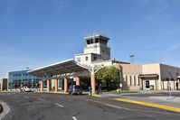
Latest photo of Idaho Falls Regional Airport (IDA)
Jack Poelstra
| FAA Information Effective | 2026-07-09 |
| Airport Identifier | IDA |
| Airport Status | Operational |
| Longitude/Latitude |
112°4'14.9530"
W /
43°30'49.2240"
N -112.070820 / 43.513673 (Estimated) |
| Elevation | 4743.70 ft / 1445.88 m (Surveyed) |
| Land | 866 acres |
| From nearest city | 2 nautical miles NW of Idaho Falls, ID |
| Location | Bonneville County, ID |
| Magnetic Variation | 12E (2020) |
| Airport Use | Open to public |
| Wind indicator | Yes |
| Segmented Circle | Yes |
| Control Tower | ATCT |
| Lighting Schedule | SEE RMK |
| Beacon Color | White-Green (lighted land airport) |
| Landing fee charge | No |
| Sectional chart | SALT LAKE CITY |
| Region | ANM - Northwest Mountain |
| Responsible ARTCC | ZLC - SALT LAKE CITY |
| Tie-in FSS | BOI - BOISE |
| FSS on Airport | No |
| FSS Toll Free | 1-800-WX-BRIEF |
| NOTAMs Facility | IDA (NOTAM-d service available) |
| Certification type/date | 1993/05 |
Runway 03/21
| Dimensions | 9002 x 150 ft (2744 x 46 m) |
| Surface | ASPH (GOOD) |
| Surface treatment | Saw-cut or plastic Grooved |
| Edge lights | High |
| 03 | 21 | |
|---|---|---|
| Alignment | 38° | 218° |
| Physical elevation | 4742.00 ft | 4731.30 ft |
| Coordinates | 43.502516 / -112.085214 | 43.521967 / -112.064321 |
| Traffic pattern | Left | Left |
| Runway marking | Precision instrument , Good Condition | Precision instrument , Good Condition |
| ILS type | ILS/DME | |
| VGSI | 4-light PAPI on left | 4-light PAPI on left |
| RVR equipment | rollout | touchdown |
| Approach light | MALSR | |
| Runway end lights | Yes |
Runway 17/35
| Dimensions | 3964 x 75 ft (1208 x 23 m) |
| Surface | ASPH (GOOD) |
| Surface treatment | |
| Edge lights | Medium |
| 17 | 35 | |
|---|---|---|
| Alignment | 182° | 2° |
| Physical elevation | 4731.10 ft | 4731.20 ft |
| Coordinates | 43.522357 / -112.061603 | 43.511490 / -112.062103 |
| Traffic pattern | Left | Left |
| Runway marking | Basic , Good Condition | Basic , Good Condition |
| VGSI | 2-light PAPI on left | 4-light PAPI on left |
- FQT VEHICLE TFC ON EAST RAMP ADJ TO TWY B.
- FOR CD IF UNA TO CTC ON FSS FREQ, CTC SALT LAKE ARTCC AT 801-320-2568.
- FLOCKS OF BIRDS & WATERFOWL ON & INVOF ARPT ALL YEAR.
- EXTSV AGRICULTURAL OPNS INVOF OF ARPT.
- ACFT OPS BE ALERT FOR POSSIBLE INCURSIONS; NO LINE OF SIGHT BTN RWYS.
- SFC CONDITIONS UNMONITORED 2300-0530.
- RWY 21 AND RWY 17 APCH ENDS IN CLOSE PROXIMITY. WRONG RWY DEP/ARR RISK. CHK RWY ALNMT. INTERSECTING FLT PATHS FOR RWYS 21 & 17, AND RWYS 03 & 35.
- SELF SVC FUEL EAST OF TWY BRAVO AVBL 24 HRS.
- ALL COMMERCIAL ACFT ADVISE PRIOR TO PUSHBACK.
- IDA SVC GND COM OUTLET CMSND KEY FREQ 121.725: 2 TIMES FUEL DLVY; 4 TIMES SLC ARTCC; 6 TIMES BOI FSS; 8 TIMES 911 DISPATCH SVC WHEN TWR CLSD.