Northeast Philadelphia Airport (PNE)
Northeast Philadelphia Airport (PNE)
PNE
Northeast Philadelphia Airport (PNE)
Philadelphia, PA
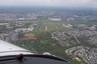
Latest photo of Northeast Philadelphia Airport (PNE)
Glenn Long
| FAA Information Effective | 2026-07-09 |
| Airport Identifier | PNE |
| Airport Status | Operational |
| Longitude/Latitude |
75°0'38.0800"
W /
40°4'54.9780"
N -75.010578 / 40.081938 (Estimated) |
| Elevation | 119.80 ft / 36.52 m (Surveyed) |
| Land | 1150 acres |
| From nearest city | 10 nautical miles NE of Philadelphia, PA |
| Location | Philadelphia County, PA |
| Magnetic Variation | 12W (2005) |
| Airport Use | Open to public |
| Wind indicator | Yes |
| Segmented Circle | No |
| Control Tower | ATCT |
| Lighting Schedule | SEE RMK |
| Beacon Color | White-Green (lighted land airport) |
| Landing fee charge | Yes |
| Sectional chart | NEW YORK |
| Region | AEA - Eastern |
| Responsible ARTCC | ZNY - NEW YORK |
| Tie-in FSS | IPT - WILLIAMSPORT |
| FSS on Airport | No |
| FSS Toll Free | 1-800-WX-BRIEF |
| NOTAMs Facility | PNE (NOTAM-d service available) |
Runway 06/24
| Dimensions | 7000 x 100 ft (2134 x 30 m) |
| Surface | ASPH (GOOD) |
| Surface treatment | Saw-cut or plastic Grooved |
| Edge lights | High |
| PCN | 80 |
| 06 | 24 | |
|---|---|---|
| Alignment | 48° | 228° |
| Physical elevation | 116.70 ft | 113.70 ft |
| Coordinates | 40.077505 / -75.020258 | 40.090260 / -75.001550 |
| Traffic pattern | Left | Left |
| Runway marking | Precision instrument , Good Condition | Precision instrument , Good Condition |
| ILS type | ILS | |
| VGSI | 4-light PAPI on left | 4-light PAPI on right |
| Approach light | MALSR | |
| Runway end lights | Yes |
Runway 15/33
| Dimensions | 4999 x 150 ft (1524 x 46 m) |
| Surface | ASPH (GOOD) |
| Surface treatment | Saw-cut or plastic Grooved |
| Edge lights | Medium |
| 15 | 33 | |
|---|---|---|
| Alignment | 141° | 321° |
| Physical elevation | 119.80 ft | 107.90 ft |
| Coordinates | 40.084525 / -75.015778 | 40.073906 / -75.004461 |
| Traffic pattern | Left | Left |
| Runway marking | Non-precision instrument , Good Condition | Non-precision instrument , Good Condition |
| VGSI | 4-light PAPI on left | 4-light PAPI on left |
| Runway end lights | Yes | Yes |
- TURBOJET ACFT ARE CONFINED TO FULL LENGTH RWY 6/24 UNLESS STRONG WINDS DICTATE OTHERWISE.
- BE ALERT: 3 LARGE BRIGHTLY LIT JUMBOTRON SIGNS APRX 3 MILES NE OF AER 24. THESE SIGNS MAY CAUSE VISUAL ILLUSIONS DURING AN APCH OR MISSED APCH. PILOTS BE AT ADVISED.
- FOR CD WHEN ATCT IS CLSD CTC PHL APCH AT (800) 354-9884.
- TWY L3 SAFETY AREA NON STD.
- TWY J1 NON MOVEMENT AREA.
- COMPASS ROSE NOT FOR PUB USE.
- TWY J BTN TWY G AND HEL APN IS NON MOV AREA.
- LMT TGL OPNS TO 0900-2200 MON-SAT AND 1200-2200 SUN; 5 PER FLT FOR NOISE ABATEMENT.
- RWY 15 IS NOISE SENSITIVE. RWY 15 ARRIVALS ARE REQUESTED TO FLY AT OR ABOVE GLIDE PATH.
- ARPT CLSD TO PART 121 AIR CARRIER AND PART 135 SCHEDULED SVC.
- DEER & BIRDS ON & INVOF ARPT.
- TPA ACFT LESS THAN 12500 LBS 1120 MSL; ACFT 12500 LBS OR MORE & ALL TURBOJET & TURBINE PWRD ACFT 1620 MSL; ROTARY WING ACFT 920 MSL.
- BE ALERT FOR ARPT VEHICLES WHEN TWR CLSD.