N12160 — 2004 Embraer ERJ-145XR (EMB-145XR) Data
1
aircraft record found
N12160
2004 Embraer ERJ-145XR (EMB-145XR), c/n 145799
N12160 is a 2004 Embraer ERJ-145XR (EMB-145XR) (serial number 145799). It is configured with 2 engines and 55 seats. Registration status is listed as Valid, with ownership recorded under UNITED AIRLINES INC in Chicago, IL, United States. The profile includes 9 photos documenting this aircraft.
Latest photos of N12160

Dariusz Jezewski www.FotoDj.com
@ KEWR
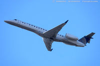
Dariusz Jezewski www.FotoDj.com
@ KEWR

Christian Maurer
@ EWR

Christian Maurer
@ IAH
Recent Routes
NO LIVE DATA
CommutAir
| Time | Callsign | FL | Speed | Heading | Route |
|---|---|---|---|---|---|
| 2026-11-15 11:36 UTC | UCA4359 / C54359 | — | 1 kt | 11° | — |
| 2026-11-15 04:22 UTC | UCA4252 / C54252 | FL20 | 129 kt | 234° |
IAD → SCE
IAD
→
SCE
Washington Dulles International Airport → State College Regional Airport |
| 2026-11-14 23:52 UTC | UCA4833 / C54833 | — | 8 kt | 298° |
ROA → IAD
ROA
→
IAD
Roanoke/blacksburg Regional (woodrum Fld) Airport → Washington Dulles International Airport |
| 2026-11-14 22:00 UTC | UCA4831 / C54831 | FL10 | 127 kt | 328° |
IAD → ROA
IAD
→
ROA
Washington Dulles International Airport → Roanoke/blacksburg Regional (woodrum Fld) Airport |
| 2026-11-14 20:02 UTC | UCA4378 / C54378 | FL4 | 145 kt | 1° | — |
| 2026-11-14 14:52 UTC | UCA4376 / C54376 | FL9 | 131 kt | 32° | — |
| 2026-11-13 21:38 UTC | UCA4848 / C54848 | FL6 | 124 kt | 0° | — |
| 2026-11-13 19:18 UTC | UCA4257 / C54257 | FL18 | 131 kt | 225° | — |
| 2026-11-13 17:06 UTC | UCA4316 / C54316 | — | 12 kt | 335° | — |
| 2026-11-13 15:24 UTC | UCA3263 / C53263 | FL17 | 120 kt | 327° | — |
| 2026-11-13 02:26 UTC | UCA4256 / C54256 | FL4 | 134 kt | 90° | — |
| 2026-11-13 00:02 UTC | UCA4981 / C54981 | FL18 | 136 kt | 235° | — |
| 2026-11-12 21:22 UTC | UCA4310 / C54310 | FL3 | 137 kt | 90° | — |
| 2026-11-12 19:22 UTC | UCA4287 / C54287 | FL29 | 192 kt | 196° | — |
| 2026-11-12 16:34 UTC | UCA4271 / C54271 | FL4 | 150 kt | 270° | — |
| 2026-11-12 01:30 UTC | UCA4832 / C54832 | — | 39 kt | 309° | — |
| 2026-11-11 22:42 UTC | UCA4816 / C54816 | FL4 | 137 kt | 270° | — |
| 2026-11-11 20:12 UTC | UCA4817 / C54817 | FL35 | 142 kt | 46° |
IAH → 5TA4
IAH
→
5TA4
George Bush Intcntl/houston Airport → 5TA4 |
| 2026-11-10 21:02 UTC | UCA4289 / C54289 | FL4 | 136 kt | 270° | — |
| 2026-11-10 18:54 UTC | UCA4896 / C54896 | FL175 | 388 kt | 73° |
IAH → MS45
IAH
→
MS45
George Bush Intcntl/houston Airport → Bhllc Airport |
| 2026-11-10 16:48 UTC | UCA4299 / C54299 | FL3 | 144 kt | 270° | — |
| 2026-11-10 14:34 UTC | UCA4286 / C54286 | FL53 | 257 kt | 208° | — |
| 2026-11-10 01:08 UTC | UCA4997 / C54997 | FL1 | 139 kt | 270° | — |
| 2026-11-09 23:12 UTC | UCA4836 / C54836 | FL1 | 148 kt | 44° | — |
| 2026-11-09 21:08 UTC | UCA4243 / C54243 | FL4 | 149 kt | 270° | — |
| 2026-11-09 18:52 UTC | UCA4272 / C54272 | FL24 | 219 kt | 69° | — |
| 2026-11-08 22:54 UTC | UCA4352 / C54352 | FL2 | 131 kt | 90° | — |
| 2026-11-08 20:02 UTC | UCA4969 / C54969 | FL15 | 135 kt | 340° | — |
| 2026-11-08 16:18 UTC | UCA4282 / C54282 | FL0 | 132 kt | 90° | — |
| 2026-11-08 03:16 UTC | UCA4320 / C54320 | FL134 | 351 kt | 101° | — |
| 2026-11-07 21:18 UTC | UCA4858 / C54858 | FL5 | 126 kt | 89° | — |
| 2026-11-07 19:18 UTC | UCA4845 / C54845 | FL85 | 289 kt | 85° |
IAH → XS33
IAH
→
XS33
George Bush Intcntl/houston Airport → Chesson Airport |
| 2026-11-07 17:54 UTC | UCA4878 / C54878 | FL3 | 125 kt | 90° | — |
| 2026-11-07 00:40 UTC | UCA4370 / C54370 | FL6 | 129 kt | 324° | — |
| 2026-11-06 21:46 UTC | UCA4859 / C54859 | FL5 | 142 kt | 270° | — |
| 2026-11-06 19:30 UTC | UCA4354 / C54354 | FL41 | 145 kt | 360° | — |
| 2026-11-06 16:44 UTC | UCA4237 / C54237 | FL5 | 135 kt | 270° | — |
| 2026-11-06 03:28 UTC | UCA4269 / C54269 | FL45 | 121 kt | 45° | — |
| 2026-11-06 00:34 UTC | UCA4348 / C54348 | FL5 | 144 kt | 270° | — |
| 2026-11-05 22:14 UTC | UCA4814 / C54814 | FL110 | 328 kt | 47° |
IAH → MS45
IAH
→
MS45
George Bush Intcntl/houston Airport → Bhllc Airport |
| 2026-11-05 20:02 UTC | UCA4303 / C54303 | FL5 | 147 kt | 270° |
IAD → ORF
IAD
→
ORF
Washington Dulles International Airport → Norfolk International Airport |
| 2026-11-05 17:32 UTC | UCA4278 / C54278 | FL17 | 135 kt | 20° | — |
| 2026-11-05 14:32 UTC | UCA4232 / C54232 | FL5 | 143 kt | 270° | — |
| 2026-11-05 01:28 UTC | UCA4313 / C54313 | FL55 | 253 kt | 206° | — |
| 2026-11-04 23:02 UTC | UCA4867 / C54867 | FL7 | 137 kt | 270° | — |
| 2026-11-04 21:14 UTC | UCA4315 / C54315 | FL6 | 135 kt | 322° | — |
| 2026-11-04 02:12 UTC | UCA4295 / C54295 | FL39 | 228 kt | 217° | — |
| 2026-11-03 00:22 UTC | UCA4249 / C54249 | FL9 | 135 kt | 329° | — |
| 2026-11-02 01:12 UTC | UCA4914 / C54914 | FL13 | 125 kt | 45° | — |
| 2026-11-01 22:00 UTC | UCA4942 / C54942 | — | 14 kt | 335° | — |
| 2026-11-01 19:06 UTC | UCA4317 / C54317 | FL2 | 133 kt | 358° | — |
| 2026-11-01 16:20 UTC | UCA4857 / C54857 | FL-2 | 132 kt | 1° | — |
| 2026-11-01 03:38 UTC | UCA4270 / C54270 | FL0 | 126 kt | 337° | — |
| 2026-11-01 01:22 UTC | UCA4259 / C54259 | — | 4 kt | 298° | — |
| 2026-10-31 23:12 UTC | UCA4364 / C54364 | FL15 | 138 kt | 103° | — |
| 2026-10-31 20:18 UTC | UCA4819 / C54819 | — | 13 kt | 101° | — |
| 2026-10-31 18:12 UTC | UCA4349 / C54349 | FL23 | 137 kt | 48° | — |
| 2026-10-31 15:06 UTC | UCA4834 / C54834 | — | 12 kt | 318° | — |
| 2026-10-31 13:36 UTC | UCA4319 / C54319 | FL15 | 136 kt | 233° | — |
| 2026-10-31 10:48 UTC | UCA4342 / C54342 | — | 12 kt | 326° | — |
| 2026-10-31 03:28 UTC | UCA4265 / C54265 | FL46 | 238 kt | 248° | — |
| 2026-10-31 01:02 UTC | UCA4302 / C54302 | — | 15 kt | 338° | — |
| 2026-10-30 22:18 UTC | UCA4250 / C54250 | FL7 | 119 kt | 297° | — |
| 2026-10-30 19:56 UTC | UCA4328 / C54328 | — | 5 kt | 332° | — |
| 2026-10-30 17:36 UTC | UCA4815 / C54815 | FL51 | 267 kt | 205° | — |
| 2026-10-30 15:24 UTC | UCA4974 / C54974 | — | 12 kt | 8° | — |
| 2026-10-30 13:30 UTC | UCA4986 / C54986 | FL7 | 128 kt | 297° | — |
| 2026-10-30 11:02 UTC | UCA4275 / C54275 | — | 17 kt | 11° | — |
| 2026-10-30 03:28 UTC | UCA4247 / C54247 | FL26 | 172 kt | 201° | — |
| 2026-10-30 00:36 UTC | UCA4853 / C54853 | — | 22 kt | 101° | — |
| 2026-10-29 22:42 UTC | UCA4977 / C54977 | FL48 | 254 kt | 35° | — |
| 2026-10-29 20:16 UTC | UCA4959 / C54959 | — | 17 kt | 11° | — |
| 2026-10-29 18:16 UTC | UCA4962 / C54962 | FL9 | 135 kt | 32° |
IAD → GSP
IAD
→
GSP
Washington Dulles International Airport → Greenville Spartanburg International Airport |
| 2026-10-28 15:42 UTC | UCA4367 / C54367 | — | 2 kt | 354° |
ROC → IAD
ROC
→
IAD
Frederick Douglass/greater Rochester International Airport → Washington Dulles International Airport |
| 2026-10-28 13:40 UTC | UCA4877 / C54877 | — | 1 kt | 298° |
IAD → ROC
IAD
→
ROC
Washington Dulles International Airport → Frederick Douglass/greater Rochester International Airport |
| 2026-10-28 01:08 UTC | UCA4235 / C54235 | — | 8 kt | 323° | — |
| 2026-10-25 14:28 UTC | UCA4812 / C54812 | FL2 | 131 kt | 358° | — |
| 2026-10-25 11:58 UTC | UCA4939 / C54939 | — | 4 kt | 315° | — |
| 2026-10-25 03:18 UTC | UCA4950 / C54950 | FL23 | 179 kt | 133° | — |
| 2026-10-24 22:42 UTC | UCA4255 / C54255 | FL9 | 142 kt | 327° | — |
| 2026-10-24 11:26 UTC | UCA4311 / C54311 | — | 15 kt | 101° | — |
| 2026-10-24 03:46 UTC | UCA4304 / C54304 | FL13 | 134 kt | 44° | — |
| 2026-10-24 01:02 UTC | UCA4954 / C54954 | — | 10 kt | 0° | — |
| 2026-10-23 22:38 UTC | UCA4945 / C54945 | FL46 | 219 kt | 46° | — |
| 2026-10-23 15:54 UTC | UCA4227 / C54227 | — | 12 kt | 284° | — |
| 2026-10-23 14:12 UTC | UCA4239 / C54239 | FL25 | 125 kt | 35° | — |
| 2026-10-22 20:32 UTC | UCA4229 / C54229 | — | 17 kt | 96° | — |
| 2026-10-22 18:24 UTC | UCA4288 / C54288 | FL17 | 163 kt | 45° | — |
| 2026-10-22 15:20 UTC | UCA4281 / C54281 | — | 18 kt | 101° | — |
| 2026-10-22 13:32 UTC | UCA4333 / C54333 | FL46 | 281 kt | 211° | — |
| 2026-10-21 19:22 UTC | UCA4938 / C54938 | — | 12 kt | 290° | — |
| 2026-10-21 17:52 UTC | UCA4253 / C54253 | FL17 | 137 kt | 233° | — |
| 2026-10-21 15:24 UTC | UCA4862 / C54862 | — | 5 kt | 242° | — |
| 2026-10-21 13:28 UTC | UCA4861 / C54861 | FL26 | 171 kt | 34° | — |
| 2026-10-21 00:50 UTC | UCA4267 / C54267 | — | 3 kt | 326° | — |
| 2026-10-20 22:46 UTC | UCA4274 / C54274 | FL7 | 142 kt | 235° | — |
| 2026-10-20 20:26 UTC | UCA4291 / C54291 | — | 8 kt | 338° | — |
| 2026-10-20 18:00 UTC | UCA4335 / C54335 | FL4 | 131 kt | 44° | — |
| 2026-10-20 15:20 UTC | UCA4889 / C54889 | — | 0 kt | 6° | — |
| 2026-10-20 03:22 UTC | UCA4321 / C54321 | FL5 | 128 kt | 358° | — |
| 2026-10-20 01:26 UTC | UCA4874 / C54874 | — | 0 kt | 8° |
ROC → IAD
ROC
→
IAD
Frederick Douglass/greater Rochester International Airport → Washington Dulles International Airport |
| 2026-10-19 23:24 UTC | UCA4871 / C54871 | — | 0 kt | 301° |
IAD → ROC
IAD
→
ROC
Washington Dulles International Airport → Frederick Douglass/greater Rochester International Airport |
| 2026-10-19 20:06 UTC | UCA4314 / C54314 | — | 10 kt | 290° | — |
| 2026-10-19 16:52 UTC | UCA4369 / C54369 | FL4 | 144 kt | 323° | — |
| 2026-10-19 13:04 UTC | UCA4248 / C54248 | FL0 | 131 kt | 89° | — |
| 2026-10-18 23:34 UTC | UCA4842 / C54842 | FL1 | 130 kt | 90° | — |
| 2026-10-18 20:46 UTC | UCA4902 / C54902 | FL17 | 146 kt | 342° | — |
| 2026-10-18 18:02 UTC | UCA4830 / C54830 | FL2 | 136 kt | 90° | — |
| 2026-10-18 15:58 UTC | UCA4371 / C54371 | — | 10 kt | 284° | — |
| 2026-10-18 13:44 UTC | UCA4226 / C54226 | FL0 | 125 kt | 90° | — |
| 2026-10-18 01:06 UTC | UCA4936 / C54936 | — | 3 kt | 104° | — |
| 2026-10-17 16:02 UTC | UCA4821 / C54821 | FL150 | 337 kt | 314° | — |
| 2026-10-17 13:36 UTC | UCA4863 / C54863 | FL1 | 142 kt | 269° | — |
| 2026-10-16 23:26 UTC | UCA4306 / C54306 | FL37 | 139 kt | 359° | — |
Live location data from OpenSky Network
Airframe Info
| Manufacturer | Embraer |
| Model | ERJ-145XR (EMB-145XR) Search all Embraer ERJ-145XR (EMB-145XR) |
| Year built | 2004 |
| Construction Number (C/N) | 145799 |
| Aircraft Type | Fixed wing multi engine |
| Number of Seats | 55 |
| Number of Engines | 2 |
| Engine Type | Turbofan |
| Engine Manufacturer and Model | Rolls-royc AE3007 SER |
Aircraft
| Registration Number | N12160 |
| Mode S (ICAO24) Code | a05aac |
| Certification Class | Standard |
| Certification Issued | 2019-06-26 |
| Air Worthiness Test | 2004-04-16 |
| Last Action Taken | 2023-08-11 |
| Current Status | Valid |
Owner
| Registration Type | Corporation |
| Owner | UNITED AIRLINES INC |
| Address |
Chicago, IL 606067147 United States |
| Region | Great Lakes |