N14148 — 2003 Embraer ERJ-145XR (EMB-145XR) Data
2
aircraft records found
N14148
2003 Embraer ERJ-145XR (EMB-145XR), c/n 145751
N14148 is a 2003 Embraer ERJ-145XR (EMB-145XR) (serial number 145751). It is configured with 2 engines and 55 seats. Registration status is listed as Valid, with ownership recorded under UNITED AIRLINES INC in Chicago, IL, United States. The profile includes 11 photos documenting this aircraft.
Latest photos of N14148
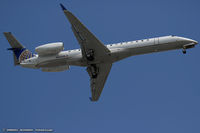
Dariusz Jezewski www.FotoDj.com
@ KEWR

Christian Maurer
@ IAH

Ronald Barker
@ KDEN

Ronald Barker
@ KRIC
Recent Routes
NO LIVE DATA
CommutAir
| Time | Callsign | FL | Speed | Heading | Route |
|---|---|---|---|---|---|
| 2026-11-13 19:44 UTC | UCA4303 / C54303 | FL4 | 140 kt | 270° |
IAD → ORF
IAD
→
ORF
Washington Dulles International Airport → Norfolk International Airport |
| 2026-11-13 17:30 UTC | UCA4278 / C54278 | FL15 | 135 kt | 20° | — |
| 2026-11-13 13:48 UTC | UCA4330 / C54330 | FL1 | 134 kt | 270° | — |
| 2026-11-13 03:10 UTC | UCA4985 / C54985 | FL75 | 284 kt | 83° | — |
| 2026-11-13 01:22 UTC | UCA4997 / C54997 | FL3 | 144 kt | 90° | — |
| 2026-11-12 23:36 UTC | UCA4836 / C54836 | FL2 | 135 kt | 314° | — |
| 2026-11-12 21:14 UTC | UCA4374 / C54374 | FL3 | 142 kt | 89° | — |
| 2026-11-12 19:20 UTC | UCA4251 / C54251 | — | 0 kt | 107° | — |
| 2026-11-12 16:20 UTC | UCA4841 / C54841 | FL4 | 144 kt | 270° | — |
| 2026-11-12 05:28 UTC | UCA4901 / C54901 | FL9 | 135 kt | 181° |
IAD → HSV
IAD
→
HSV
Washington Dulles International Airport → Huntsville Intl-carl T Jones Fld Airport |
| 2026-11-12 01:38 UTC | UCA4853 / C54853 | — | 3 kt | 17° | — |
| 2026-11-11 23:32 UTC | UCA4977 / C54977 | FL40 | 197 kt | 359° | — |
| 2026-11-11 21:04 UTC | UCA4860 / C54860 | — | 12 kt | 101° |
ROC → IAD
ROC
→
IAD
Frederick Douglass/greater Rochester International Airport → Washington Dulles International Airport |
| 2026-11-11 19:08 UTC | UCA4843 / C54843 | — | 0 kt | 301° |
IAD → ROC
IAD
→
ROC
Washington Dulles International Airport → Frederick Douglass/greater Rochester International Airport |
| 2026-11-11 16:10 UTC | UCA4857 / C54857 | — | 6 kt | 307° | — |
| 2026-11-11 04:28 UTC | UCA4270 / C54270 | FL6 | 129 kt | 337° | — |
| 2026-11-11 01:48 UTC | UCA4975 / C54975 | — | 4 kt | 343° | — |
| 2026-11-10 23:50 UTC | UCA4847 / C54847 | FL20 | 122 kt | 233° | — |
| 2026-11-10 20:40 UTC | UCA4938 / C54938 | — | 3 kt | 37° | — |
| 2026-11-10 18:58 UTC | UCA4253 / C54253 | FL24 | 141 kt | 233° | — |
| 2026-11-10 16:50 UTC | UCA4254 / C54254 | — | 12 kt | 101° | — |
| 2026-11-10 14:38 UTC | UCA4327 / C54327 | FL10 | 117 kt | 235° | — |
| 2026-11-10 11:48 UTC | UCA4342 / C54342 | — | 0 kt | 6° | — |
| 2026-11-10 04:26 UTC | UCA4265 / C54265 | FL39 | 207 kt | 258° | — |
| 2026-11-10 02:14 UTC | UCA4242 / C54242 | — | 9 kt | 101° | — |
| 2026-11-10 00:04 UTC | UCA4963 / C54963 | FL8 | 132 kt | 212° |
IAD → GSP
IAD
→
GSP
Washington Dulles International Airport → Greenville Spartanburg International Airport |
| 2026-11-09 19:16 UTC | UCA4367 / C54367 | — | 4 kt | 315° |
ROC → IAD
ROC
→
IAD
Frederick Douglass/greater Rochester International Airport → Washington Dulles International Airport |
| 2026-11-09 17:34 UTC | UCA4877 / C54877 | — | 0 kt | 301° |
IAD → ROC
IAD
→
ROC
Washington Dulles International Airport → Frederick Douglass/greater Rochester International Airport |
| 2026-11-09 12:02 UTC | UCA4939 / C54939 | — | 4 kt | 8° | — |
| 2026-11-09 04:38 UTC | UCA4950 / C54950 | FL68 | 281 kt | 36° | — |
| 2026-11-08 21:14 UTC | UCA4925 / C54925 | — | 5 kt | 343° | — |
| 2026-11-08 18:42 UTC | UCA4930 / C54930 | FL8 | 145 kt | 337° | — |
| 2026-11-08 16:08 UTC | UCA4974 / C54974 | — | 12 kt | 312° | — |
| 2026-11-08 14:18 UTC | UCA4986 / C54986 | FL9 | 117 kt | 297° | — |
| 2026-11-08 11:58 UTC | UCA4275 / C54275 | — | 6 kt | 11° | — |
| 2026-11-08 04:32 UTC | UCA4247 / C54247 | FL23 | 168 kt | 36° | — |
| 2026-11-08 01:46 UTC | UCA4874 / C54874 | — | 3 kt | 11° |
ROC → IAD
ROC
→
IAD
Frederick Douglass/greater Rochester International Airport → Washington Dulles International Airport |
| 2026-11-07 23:58 UTC | UCA4871 / C54871 | — | 0 kt | 301° |
IAD → ROC
IAD
→
ROC
Washington Dulles International Airport → Frederick Douglass/greater Rochester International Airport |
| 2026-11-07 21:10 UTC | UCA4819 / C54819 | — | 17 kt | 101° | — |
| 2026-11-07 18:48 UTC | UCA4349 / C54349 | FL26 | 188 kt | 54° | — |
| 2026-11-07 16:26 UTC | UCA4366 / C54366 | — | 12 kt | 101° | — |
| 2026-11-07 14:46 UTC | UCA4350 / C54350 | FL2 | 138 kt | 37° | — |
| 2026-11-07 01:44 UTC | UCA4940 / C54940 | — | 0 kt | 332° | — |
| 2026-11-06 23:00 UTC | UCA4266 / C54266 | FL49 | 165 kt | 203° | — |
| 2026-11-06 20:58 UTC | UCA4314 / C54314 | — | 10 kt | 101° | — |
| 2026-11-06 17:26 UTC | UCA4369 / C54369 | FL6 | 132 kt | 326° | — |
| 2026-11-06 13:58 UTC | UCA4318 / C54318 | FL4 | 131 kt | 270° | — |
| 2026-11-06 01:52 UTC | UCA4334 / C54334 | FL181 | 403 kt | 73° | — |
| 2026-11-05 22:44 UTC | UCA4956 / C54956 | FL7 | 144 kt | 270° | — |
| 2026-11-05 19:54 UTC | UCA4337 / C54337 | — | 6 kt | 321° | — |
| 2026-11-05 16:30 UTC | UCA4838 / C54838 | FL4 | 142 kt | 269° | — |
| 2026-11-05 00:12 UTC | UCA4855 / C54855 | FL17 | 142 kt | 20° | — |
| 2026-11-04 21:02 UTC | UCA4980 / C54980 | FL6 | 143 kt | 270° | — |
| 2026-11-04 19:04 UTC | UCA4236 / C54236 | FL43 | 277 kt | 195° | — |
| 2026-11-04 15:38 UTC | UCA4837 / C54837 | FL5 | 146 kt | 270° | — |
| 2026-11-04 03:28 UTC | UCA5004 / C55004 | FL29 | 198 kt | 85° | — |
| 2026-11-04 00:26 UTC | UCA4309 / C54309 | FL7 | 136 kt | 270° | — |
| 2026-11-03 22:16 UTC | UCA4279 / C54279 | FL27 | 269 kt | 41° | — |
| 2026-11-03 17:52 UTC | UCA4878 / C54878 | FL6 | 144 kt | 269° | — |
| 2026-11-03 04:22 UTC | UCA4312 / C54312 | FL57 | 246 kt | 70° | — |
| 2026-11-02 02:24 UTC | UCA4859 / C54859 | FL3 | 154 kt | 270° | — |
| 2026-11-02 00:34 UTC | UCA4306 / C54306 | FL46 | 144 kt | 179° | — |
| 2026-11-01 20:04 UTC | UCA4851 / C54851 | FL6 | 150 kt | 271° | — |
| 2026-11-01 17:46 UTC | UCA4225 / C54225 | FL41 | 247 kt | 127° | — |
| 2026-11-01 00:26 UTC | UCA4363 / C54363 | FL3 | 123 kt | 90° | — |
| 2026-10-31 21:56 UTC | UCA4361 / C54361 | FL14 | 135 kt | 200° | — |
| 2026-10-29 18:22 UTC | UCA4305 / C54305 | FL2 | 135 kt | 90° | — |
| 2026-10-29 16:00 UTC | UCA4290 / C54290 | FL37 | 232 kt | 239° | — |
| 2026-10-28 23:32 UTC | UCA4356 / C54356 | FL2 | 132 kt | 90° | — |
| 2026-10-28 20:48 UTC | UCA4911 / C54911 | FL18 | 138 kt | 55° | — |
| 2026-10-28 18:32 UTC | UCA4300 / C54300 | FL2 | 136 kt | 90° | — |
| 2026-10-28 16:02 UTC | UCA4261 / C54261 | FL47 | 169 kt | 181° | — |
| 2026-10-27 21:40 UTC | UCA4969 / C54969 | FL2 | 134 kt | 90° | — |
| 2026-10-27 19:02 UTC | UCA4352 / C54352 | FL38 | 251 kt | 129° | — |
| 2026-10-27 00:56 UTC | UCA4866 / C54866 | — | 3 kt | 335° |
ROA → IAD
ROA
→
IAD
Roanoke/blacksburg Regional (woodrum Fld) Airport → Washington Dulles International Airport |
| 2026-10-26 23:10 UTC | UCA4339 / C54339 | — | 3 kt | 42° |
IAD → ROA
IAD
→
ROA
Washington Dulles International Airport → Roanoke/blacksburg Regional (woodrum Fld) Airport |
| 2026-10-26 19:48 UTC | UCA4328 / C54328 | — | 10 kt | 101° | — |
| 2026-10-26 17:40 UTC | UCA4815 / C54815 | FL57 | 255 kt | 200° | — |
| 2026-10-26 10:52 UTC | UCA4244 / C54244 | — | 18 kt | 11° | — |
| 2026-10-26 03:26 UTC | UCA4233 / C54233 | FL2 | 136 kt | 116° |
IAD → NC43
IAD
→
NC43
Washington Dulles International Airport → Bear Pen Airport |
| 2026-10-26 01:42 UTC | UCA4259 / C54259 | — | 3 kt | 8° | — |
| 2026-10-25 22:46 UTC | UCA4364 / C54364 | FL15 | 126 kt | 44° | — |
| 2026-10-25 10:48 UTC | UCA4922 / C54922 | — | 1 kt | 340° |
ROA → IAD
ROA
→
IAD
Roanoke/blacksburg Regional (woodrum Fld) Airport → Washington Dulles International Airport |
| 2026-10-25 03:18 UTC | UCA4897 / C54897 | — | 0 kt | 42° |
IAD → ROA
IAD
→
ROA
Washington Dulles International Airport → Roanoke/blacksburg Regional (woodrum Fld) Airport |
| 2026-10-25 01:24 UTC | UCA4235 / C54235 | — | 3 kt | 315° | — |
| 2026-10-24 14:16 UTC | UCA4812 / C54812 | FL2 | 127 kt | 358° | — |
| 2026-10-24 02:34 UTC | UCA4267 / C54267 | — | 1 kt | 326° | — |
| 2026-10-24 00:10 UTC | UCA4274 / C54274 | FL7 | 129 kt | 55° | — |
| 2026-10-23 20:30 UTC | UCA4824 / C54824 | — | 18 kt | 101° | — |
| 2026-10-23 18:24 UTC | UCA4241 / C54241 | FL8 | 131 kt | 55° | — |
| 2026-10-23 15:48 UTC | UCA4283 / C54283 | — | 19 kt | 101° | — |
| 2026-10-23 13:44 UTC | UCA4818 / C54818 | FL8 | 123 kt | 106° | — |
| 2026-10-22 22:56 UTC | UCA4250 / C54250 | FL28 | 203 kt | 17° | — |
| 2026-10-22 20:18 UTC | UCA4959 / C54959 | — | 12 kt | 264° | — |
| 2026-10-22 18:16 UTC | UCA4962 / C54962 | FL8 | 137 kt | 32° |
IAD → GSP
IAD
→
GSP
Washington Dulles International Airport → Greenville Spartanburg International Airport |
| 2026-10-22 15:36 UTC | UCA4325 / C54325 | — | 0 kt | 14° | — |
| 2026-10-21 23:54 UTC | UCA4914 / C54914 | FL16 | 136 kt | 224° | — |
| 2026-10-21 15:28 UTC | UCA4889 / C54889 | — | 3 kt | 37° | — |
| 2026-10-20 23:04 UTC | UCA4926 / C54926 | FL4 | 126 kt | 358° | — |
| 2026-10-20 21:04 UTC | UCA4942 / C54942 | — | 0 kt | 51° | — |
| 2026-10-20 17:46 UTC | UCA4317 / C54317 | FL4 | 133 kt | 358° | — |
| 2026-10-20 15:34 UTC | UCA4269 / C54269 | — | 0 kt | 11° | — |
| 2026-10-19 19:14 UTC | UCA4848 / C54848 | — | 6 kt | 42° | — |
| 2026-10-19 14:14 UTC | UCA4257 / C54257 | FL9 | 137 kt | 225° | — |
| 2026-10-19 11:28 UTC | UCA4970 / C54970 | — | 12 kt | 281° | — |
| 2026-10-19 03:28 UTC | UCA4321 / C54321 | FL3 | 150 kt | 358° | — |
| 2026-10-18 20:40 UTC | UCA4285 / C54285 | — | 3 kt | 309° | — |
| 2026-10-18 15:32 UTC | UCA4240 / C54240 | — | 15 kt | 82° | — |
| 2026-10-18 01:18 UTC | UCA4292 / C54292 | FL5 | 119 kt | 1° | — |
| 2026-10-16 15:22 UTC | UCA4357 / C54357 | FL2 | 140 kt | 270° |
IAD → ROC
IAD
→
ROC
Washington Dulles International Airport → Frederick Douglass/greater Rochester International Airport |
| 2026-10-16 05:12 UTC | UCA4892 / C54892 | — | 1 kt | 121° | — |
| 2026-10-15 20:34 UTC | UCA4322 / C54322 | FL44 | 269 kt | 258° | — |
| 2026-10-15 18:16 UTC | UCA4830 / C54830 | FL3 | 143 kt | 90° | — |
| 2026-10-15 16:06 UTC | UCA4371 / C54371 | — | 17 kt | 293° | — |
| 2026-10-15 13:32 UTC | UCA4226 / C54226 | FL3 | 140 kt | 270° | — |
| 2026-10-15 01:04 UTC | UCA4936 / C54936 | — | 5 kt | 104° | — |
Live location data from OpenSky Network
Airframe Info
| Manufacturer | Embraer |
| Model | ERJ-145XR (EMB-145XR) Search all Embraer ERJ-145XR (EMB-145XR) |
| Year built | 2003 |
| Construction Number (C/N) | 145751 |
| Aircraft Type | Fixed wing multi engine |
| Number of Seats | 55 |
| Number of Engines | 2 |
| Engine Type | Turbofan |
| Engine Manufacturer and Model | Rolls-Royce AE3007 SER |
Aircraft
| Registration Number | N14148 |
| Mode S (ICAO24) Code | a0a96c |
| Certification Class | Standard |
| Certification Issued | 2019-01-31 |
| Air Worthiness Test | 2003-09-20 |
| Last Action Taken | 2023-07-07 |
| Current Status | Valid |
Owner
| Registration Type | Corporation |
| Owner | UNITED AIRLINES INC |
| Address |
Chicago, IL 606067147 United States |
| Region | Great Lakes |