N14162 — 2004 Embraer ERJ-145XR (EMB-145XR) Data
1
aircraft record found
N14162
2004 Embraer ERJ-145XR (EMB-145XR), c/n 14500808
N14162 is a 2004 Embraer ERJ-145XR (EMB-145XR) (serial number 14500808). It is configured with 2 engines and 55 seats. Registration status is listed as Valid, with ownership recorded under UNITED AIRLINES INC in Chicago, IL, United States. The profile includes 9 photos documenting this aircraft.
Latest photos of N14162
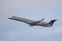
Dariusz Jezewski www.FotoDj.com
@ KEWR

Dariusz Jezewski FotoDJ.com
@ KEWR

Dariusz Jezewski www.FotoDj.com
@ KEWR

Christian Maurer
@ IAH
Recent Routes
NO LIVE DATA
CommutAir
| Time | Callsign | FL | Speed | Heading | Route |
|---|---|---|---|---|---|
| 2026-11-13 16:54 UTC | UCA4866 / C54866 | — | 4 kt | 11° |
ROA → IAD
ROA
→
IAD
Roanoke/blacksburg Regional (woodrum Fld) Airport → Washington Dulles International Airport |
| 2026-11-13 14:36 UTC | UCA4831 / C54831 | — | 18 kt | 155° |
IAD → ROA
IAD
→
ROA
Washington Dulles International Airport → Roanoke/blacksburg Regional (woodrum Fld) Airport |
| 2026-11-12 19:02 UTC | UCA4238 / C54238 | — | 10 kt | 101° | — |
| 2026-11-12 14:32 UTC | UCA4880 / C54880 | FL31 | 188 kt | 87° | — |
| 2026-11-12 12:18 UTC | UCA4939 / C54939 | — | 1 kt | 312° | — |
| 2026-11-12 04:22 UTC | UCA4950 / C54950 | FL34 | 186 kt | 131° | — |
| 2026-11-11 23:42 UTC | UCA4339 / C54339 | FL13 | 136 kt | 230° |
IAD → ROA
IAD
→
ROA
Washington Dulles International Airport → Roanoke/blacksburg Regional (woodrum Fld) Airport |
| 2026-11-11 21:14 UTC | UCA4291 / C54291 | — | 11 kt | 354° | — |
| 2026-11-11 19:38 UTC | UCA4335 / C54335 | FL10 | 149 kt | 224° | — |
| 2026-11-11 16:16 UTC | UCA4325 / C54325 | — | 6 kt | 346° | — |
| 2026-11-11 00:26 UTC | UCA4914 / C54914 | FL12 | 150 kt | 44° | — |
| 2026-11-10 20:50 UTC | UCA4860 / C54860 | — | 1 kt | 11° |
ROC → IAD
ROC
→
IAD
Frederick Douglass/greater Rochester International Airport → Washington Dulles International Airport |
| 2026-11-10 19:12 UTC | UCA4843 / C54843 | — | 0 kt | 301° |
IAD → ROC
IAD
→
ROC
Washington Dulles International Airport → Frederick Douglass/greater Rochester International Airport |
| 2026-11-10 16:06 UTC | UCA4834 / C54834 | — | 20 kt | 101° | — |
| 2026-11-10 04:36 UTC | UCA4252 / C54252 | FL19 | 136 kt | 233° |
IAD → SCE
IAD
→
SCE
Washington Dulles International Airport → State College Regional Airport |
| 2026-11-10 01:46 UTC | UCA4975 / C54975 | — | 13 kt | 321° | — |
| 2026-11-10 00:02 UTC | UCA4847 / C54847 | FL17 | 126 kt | 233° | — |
| 2026-11-09 22:14 UTC | UCA4230 / C54230 | — | 10 kt | 312° | — |
| 2026-11-09 20:24 UTC | UCA4234 / C54234 | FL29 | 145 kt | 34° | — |
| 2026-11-09 17:28 UTC | UCA4281 / C54281 | — | 10 kt | 152° | — |
| 2026-11-09 14:24 UTC | UCA4333 / C54333 | FL44 | 225 kt | 253° | — |
| 2026-11-09 04:20 UTC | UCA4853 / C54853 | — | 13 kt | 318° | — |
| 2026-11-08 23:46 UTC | UCA4977 / C54977 | FL46 | 271 kt | 43° | — |
| 2026-11-08 16:32 UTC | UCA4240 / C54240 | — | 8 kt | 101° | — |
| 2026-11-08 05:20 UTC | UCA4901 / C54901 | FL4 | 125 kt | 1° |
IAD → HSV
IAD
→
HSV
Washington Dulles International Airport → Huntsville Intl-carl T Jones Fld Airport |
| 2026-11-08 02:26 UTC | UCA4259 / C54259 | — | 3 kt | 37° | — |
| 2026-11-08 00:18 UTC | UCA4364 / C54364 | FL16 | 168 kt | 104° | — |
| 2026-11-07 20:44 UTC | UCA4268 / C54268 | — | 12 kt | 307° | — |
| 2026-11-07 18:38 UTC | UCA4372 / C54372 | FL9 | 126 kt | 297° | — |
| 2026-11-07 16:16 UTC | UCA4857 / C54857 | — | 6 kt | 309° | — |
| 2026-11-07 04:50 UTC | UCA4270 / C54270 | FL6 | 131 kt | 336° | — |
| 2026-11-07 02:02 UTC | UCA4954 / C54954 | — | 13 kt | 281° | — |
| 2026-11-07 00:16 UTC | UCA4945 / C54945 | FL57 | 248 kt | 17° | — |
| 2026-11-06 20:22 UTC | UCA4848 / C54848 | — | 14 kt | 101° | — |
| 2026-11-06 16:50 UTC | UCA4257 / C54257 | FL15 | 139 kt | 224° | — |
| 2026-11-04 21:22 UTC | UCA4819 / C54819 | — | 8 kt | 8° | — |
| 2026-11-04 18:52 UTC | UCA4349 / C54349 | FL29 | 178 kt | 220° | — |
| 2026-11-04 15:04 UTC | N14162 | — | 3 kt | 113° | — |
| 2026-11-02 02:14 UTC | UCA4267 / C54267 | — | 14 kt | 101° | — |
| 2026-11-01 23:46 UTC | UCA4274 / C54274 | — | 8 kt | 149° | — |
| 2026-11-01 18:36 UTC | UCA4815 / C54815 | FL38 | 250 kt | 225° | — |
| 2026-11-01 12:22 UTC | UCA4311 / C54311 | — | 6 kt | 188° | — |
| 2026-10-31 20:40 UTC | UCA4322 / C54322 | — | 12 kt | 8° | — |
| 2026-10-31 17:42 UTC | UCA4343 / C54343 | FL1 | 117 kt | 311° | — |
| 2026-10-31 15:26 UTC | UCA4889 / C54889 | — | 2 kt | 346° | — |
| 2026-10-31 03:22 UTC | UCA4321 / C54321 | FL5 | 133 kt | 357° | — |
| 2026-10-30 19:56 UTC | UCA4833 / C54833 | — | 10 kt | 101° |
ROA → IAD
ROA
→
IAD
Roanoke/blacksburg Regional (woodrum Fld) Airport → Washington Dulles International Airport |
| 2026-10-30 15:40 UTC | UCA4367 / C54367 | — | 4 kt | 298° |
ROC → IAD
ROC
→
IAD
Frederick Douglass/greater Rochester International Airport → Washington Dulles International Airport |
| 2026-10-30 13:42 UTC | UCA4877 / C54877 | — | 3 kt | 301° |
IAD → ROC
IAD
→
ROC
Washington Dulles International Airport → Frederick Douglass/greater Rochester International Airport |
| 2026-10-30 10:58 UTC | UCA4342 / C54342 | — | 16 kt | 93° | — |
| 2026-10-30 03:20 UTC | UCA4265 / C54265 | FL28 | 211 kt | 200° | — |
| 2026-10-30 01:10 UTC | UCA4235 / C54235 | — | 16 kt | 11° | — |
| 2026-10-29 14:04 UTC | UCA4812 / C54812 | FL1 | 123 kt | 178° | — |
| 2026-10-28 15:52 UTC | UCA4974 / C54974 | — | 1 kt | 346° | — |
| 2026-10-28 03:16 UTC | UCA4233 / C54233 | FL2 | 129 kt | 116° |
IAD → NC43
IAD
→
NC43
Washington Dulles International Airport → Bear Pen Airport |
| 2026-10-27 20:16 UTC | UCA4229 / C54229 | — | 13 kt | 101° | — |
| 2026-10-27 18:08 UTC | UCA4288 / C54288 | FL19 | 160 kt | 104° | — |
| 2026-10-26 22:54 UTC | UCA4823 / C54823 | — | 13 kt | 141° |
IAD → BUF
IAD
→
BUF
Washington Dulles International Airport → Buffalo Niagara International Airport |
| 2026-10-26 15:40 UTC | UCA4227 / C54227 | — | 5 kt | 191° | — |
| 2026-10-26 13:34 UTC | UCA4239 / C54239 | FL36 | 245 kt | 36° | — |
| 2026-10-26 01:04 UTC | UCA4351 / C54351 | — | 14 kt | 101° | — |
| 2026-10-25 21:18 UTC | UCA4946 / C54946 | FL3 | 140 kt | 180° | — |
| 2026-10-25 18:18 UTC | UCA4300 / C54300 | FL1 | 126 kt | 89° | — |
| 2026-10-25 15:54 UTC | UCA4261 / C54261 | FL45 | 141 kt | 181° | — |
| 2026-10-25 13:16 UTC | UCA4837 / C54837 | FL1 | 122 kt | 90° | — |
| 2026-10-25 00:18 UTC | UCA5004 / C55004 | FL20 | 214 kt | 67° | — |
| 2026-10-24 20:44 UTC | UCA4275 / C54275 | FL1 | 136 kt | 90° | — |
| 2026-10-24 01:58 UTC | UCA4856 / C54856 | FL4 | 128 kt | 135° | — |
| 2026-10-24 00:02 UTC | UCA4365 / C54365 | FL3 | 143 kt | 269° | — |
| 2026-10-23 22:16 UTC | UCA4929 / C54929 | FL58 | 266 kt | 191° | — |
| 2026-10-23 18:12 UTC | UCA5013 / C55013 | FL2 | 141 kt | 270° | — |
| 2026-10-23 16:02 UTC | UCA5014 / C55014 | FL40 | 126 kt | 179° | — |
| 2026-10-23 13:02 UTC | UCA4248 / C54248 | — | 4 kt | 45° | — |
| 2026-10-22 22:32 UTC | UCA4377 / C54377 | FL2 | 137 kt | 90° | — |
| 2026-10-22 21:02 UTC | UCA4825 / C54825 | FL3 | 132 kt | 137° | — |
| 2026-10-22 19:16 UTC | UCA4329 / C54329 | FL2 | 142 kt | 90° | — |
| 2026-10-22 17:34 UTC | UCA4813 / C54813 | FL65 | 252 kt | 225° | — |
| 2026-10-22 15:36 UTC | UCA4236 / C54236 | FL3 | 136 kt | 91° | — |
| 2026-10-22 02:22 UTC | UCA4320 / C54320 | FL117 | 349 kt | 70° | — |
| 2026-10-21 15:44 UTC | UCA4358 / C54358 | FL1 | 136 kt | 91° | — |
| 2026-10-21 13:34 UTC | UCA4324 / C54324 | FL43 | 243 kt | 193° | — |
| 2026-10-19 21:20 UTC | UCA4256 / C54256 | FL3 | 130 kt | 90° | — |
| 2026-10-19 18:28 UTC | UCA4249 / C54249 | FL10 | 139 kt | 160° | — |
| 2026-10-19 00:22 UTC | UCA4334 / C54334 | FL151 | 413 kt | 92° | — |
| 2026-10-18 20:16 UTC | UCA4289 / C54289 | FL3 | 136 kt | 90° | — |
| 2026-10-18 17:56 UTC | UCA4896 / C54896 | FL127 | 381 kt | 73° |
IAH → MS45
IAH
→
MS45
George Bush Intcntl/houston Airport → Bhllc Airport |
| 2026-10-18 15:10 UTC | UCA4357 / C54357 | FL0 | 134 kt | 90° |
IAD → ROC
IAD
→
ROC
Washington Dulles International Airport → Frederick Douglass/greater Rochester International Airport |
| 2026-10-18 03:58 UTC | UCA4892 / C54892 | — | 1 kt | 121° | — |
| 2026-10-18 00:48 UTC | UCA4941 / C54941 | FL1 | 130 kt | 270° | — |
| 2026-10-17 22:34 UTC | UCA4290 / C54290 | FL-1 | 131 kt | 43° | — |
| 2026-10-17 20:02 UTC | UCA4980 / C54980 | FL0 | 157 kt | 90° | — |
| 2026-10-17 18:08 UTC | UCA4287 / C54287 | FL58 | 269 kt | 202° | — |
| 2026-10-17 16:06 UTC | UCA4302 / C54302 | FL1 | 131 kt | 90° | — |
| 2026-10-17 13:54 UTC | UCA4280 / C54280 | — | 6 kt | 174° | — |
| 2026-10-16 20:02 UTC | UCA4356 / C54356 | FL2 | 145 kt | 271° | — |
| 2026-10-16 15:24 UTC | UCA4224 / C54224 | FL2 | 150 kt | 270° | — |
| 2026-10-16 02:50 UTC | UCA4839 / C54839 | FL128 | 282 kt | 299° | — |
| 2026-10-15 23:12 UTC | UCA4923 / C54923 | FL5 | 131 kt | 90° | — |
| 2026-10-15 20:48 UTC | UCA4307 / C54307 | FL73 | 246 kt | 87° | — |
| 2026-10-15 18:20 UTC | UCA4245 / C54245 | FL5 | 148 kt | 90° | — |
| 2026-10-15 16:08 UTC | UCA4347 / C54347 | FL18 | 178 kt | 158° |
IAH → MS59
IAH
→
MS59
George Bush Intcntl/houston Airport → Valley Of The Moon Airport |
| 2026-10-15 13:08 UTC | UCA4318 / C54318 | FL1 | 141 kt | 270° | — |
Live location data from OpenSky Network
Airframe Info
| Manufacturer | Embraer |
| Model | ERJ-145XR (EMB-145XR) Search all Embraer ERJ-145XR (EMB-145XR) |
| Year built | 2004 |
| Construction Number (C/N) | 14500808 |
| Aircraft Type | Fixed wing multi engine |
| Number of Seats | 55 |
| Number of Engines | 2 |
| Engine Type | Turbofan |
| Engine Manufacturer and Model | Rolls-Royce Ae3007A1E |
Aircraft
| Registration Number | N14162 |
| Mode S (ICAO24) Code | a0a9ac |
| Certification Class | Standard |
| Certification Issued | 2019-06-27 |
| Air Worthiness Test | 2004-05-12 |
| Last Action Taken | 2023-08-11 |
| Current Status | Valid |
Owner
| Registration Type | Corporation |
| Owner | UNITED AIRLINES INC |
| Address |
Chicago, IL 606067147 United States |
| Region | Great Lakes |