Aircraft N517AE Data
1
aircraft record found
N517AE
2003 Bombardier CRJ-701ER (CL-600-2C10) Regional Jet, c/n 10124
Latest photos of N517AE
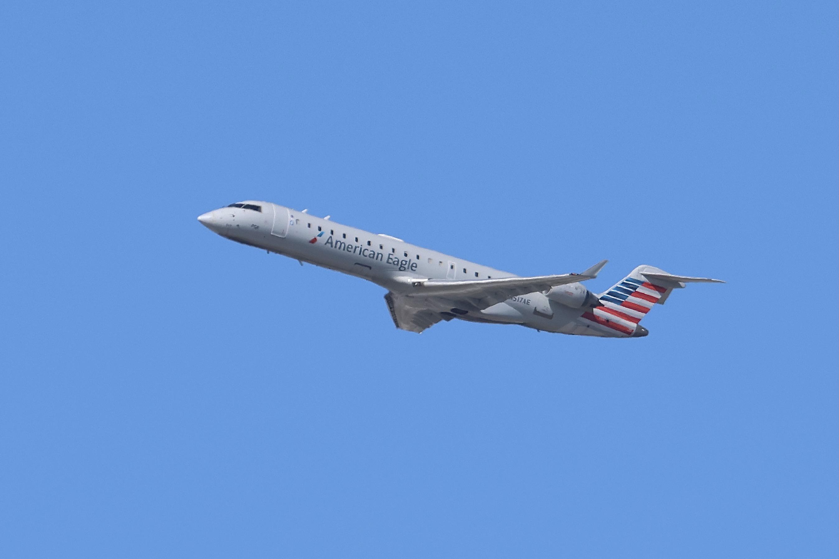
MarkKalfas
@ KORD

MarkKalfas
@ KORD
Mark Pasqualino
@ KORD
Alex2095
@ KPIT
Recent Routes
| Time | Callsign | FL | Speed | Heading | Route |
|---|---|---|---|---|---|
| 2026-10-24 02:40 UTC | JIA5357 | FL295 | 436 kt | 219° | — |
| 2026-10-24 01:22 UTC | JIA5427 | — | 1 kt | 301° | — |
| 2026-10-23 23:08 UTC | JIA5618 | FL8 | 133 kt | 32° | — |
| 2026-10-23 19:54 UTC | JIA5286 | — | 0 kt | 338° | — |
| 2026-10-23 15:58 UTC | JIA5247 | FL0 | 129 kt | 311° | — |
| 2026-10-23 13:30 UTC | JIA5369 | — | 4 kt | 304° | — |
| 2026-10-23 03:42 UTC | JIA5432 | FL8 | 130 kt | 132° | — |
| 2026-10-23 00:08 UTC | JIA5147 | — | 68 kt | 321° | — |
| 2026-10-22 21:34 UTC | JIA5610 | FL19 | 136 kt | 56° | — |
| 2026-10-22 18:40 UTC | JIA5521 | — | 25 kt | 273° |
DFW → KM80
DFW
→
KM80
Dallas-fort Worth International Airport → Scott Airport |
| 2026-10-22 14:04 UTC | JIA5294 | — | 10 kt | 335° | — |
| 2026-10-22 03:12 UTC | JIA5066 | FL77 | 279 kt | 96° | — |
| 2026-10-21 23:58 UTC | JIA5605 | — | 1 kt | 48° | — |
| 2026-10-21 20:28 UTC | JIA5649 | — | 13 kt | 281° | — |
| 2026-10-21 18:40 UTC | JIA5372 | FL2 | 144 kt | 143° | — |
| 2026-10-21 16:50 UTC | JIA5173 | — | 4 kt | 340° | — |
| 2026-10-21 14:30 UTC | JIA5253 | FL3 | 128 kt | 90° | — |
| 2026-10-21 02:14 UTC | JIA5452 | — | 3 kt | 301° |
DCA → RDU
DCA
→
RDU
Ronald Reagan Washington Ntl Airport → Raleigh-durham International Airport |
| 2026-10-20 21:16 UTC | JIA5075 | — | 0 kt | 166° | — |
| 2026-10-20 16:04 UTC | JIA5282 | — | 4 kt | 262° | — |
| 2026-10-20 11:50 UTC | JIA5678 | — | 0 kt | 323° | — |
| 2026-10-20 03:46 UTC | JIA5289 | FL2 | 127 kt | 330° | — |
| 2026-10-20 01:54 UTC | JIA5377 | — | 3 kt | 194° |
PHL → BGR
PHL
→
BGR
Philadelphia International Airport → Bangor International Airport |
| 2026-10-19 21:30 UTC | JIA5254 | — | 8 kt | 256° | — |
| 2026-10-19 13:26 UTC | JIA5485 | — | 14 kt | 321° |
MSP → DCA
MSP
→
DCA
Minneapolis-st Paul Intl/wold-chamberlain Airport → Ronald Reagan Washington Ntl Airport |
| 2026-10-19 03:28 UTC | JIA5496 | — | 1 kt | 132° |
DCA → MSP
DCA
→
MSP
Ronald Reagan Washington Ntl Airport → Minneapolis-st Paul Intl/wold-chamberlain Airport |
| 2026-10-18 23:28 UTC | JIA5500 | — | 13 kt | 321° | — |
| 2026-10-18 16:00 UTC | JIA5424 | — | 13 kt | 321° | — |
| 2026-10-17 22:26 UTC | JIA5139 | FL-1 | 121 kt | 347° |
DCA → PNS
DCA
→
PNS
Ronald Reagan Washington Ntl Airport → Pensacola International Airport |
| 2026-10-17 18:42 UTC | JIA5641 | — | 13 kt | 321° | — |
| 2026-10-17 12:54 UTC | JIA5374 | — | 10 kt | 323° |
MSN → DCA
MSN
→
DCA
Dane County Rgnl/truax Fld Airport → Ronald Reagan Washington Ntl Airport |
| 2026-10-17 06:06 UTC | JIA9970 | FL5 | 120 kt | 2° | — |
| 2026-10-16 21:10 UTC | JIA5172 | FL10 | 133 kt | 0° | — |
| 2026-10-16 18:22 UTC | JIA5366 | FL5 | 134 kt | 142° | — |
| 2026-10-16 14:32 UTC | JIA5231 | — | 3 kt | 163° | — |
| 2026-10-16 03:56 UTC | JIA5230 | FL1 | 139 kt | 224° |
DCA → BTR
DCA
→
BTR
Ronald Reagan Washington Ntl Airport → Baton Rouge Metro, Ryan Fld Airport |
| 2026-10-16 00:42 UTC | JIA5637 | — | 10 kt | 321° | — |
| 2026-10-15 18:54 UTC | JIA5252 | — | 13 kt | 318° | — |
| 2026-10-15 14:36 UTC | JIA5181 | FL3 | 136 kt | 90° | — |
| 2026-10-15 12:10 UTC | JIA5353 | — | 23 kt | 273° | — |
| 2026-10-15 02:54 UTC | JIA5025 | FL159 | 380 kt | 263° | — |
| 2026-10-14 12:42 UTC | JIA5149 | — | 6 kt | 318° | — |
| 2026-10-14 00:56 UTC | JIA5484 | FL14 | 119 kt | 224° | — |
| 2026-10-13 21:44 UTC | JIA5296 | — | 4 kt | 287° |
DCA → DSM
DCA
→
DSM
Ronald Reagan Washington Ntl Airport → Des Moines International Airport |
| 2026-10-13 15:02 UTC | JIA5660 | — | 3 kt | 174° | — |
| 2026-10-13 03:22 UTC | JIA5418 | FL11 | 116 kt | 208° | — |
| 2026-10-13 01:10 UTC | JIA5326 | — | 5 kt | 298° | — |
| 2026-10-12 20:06 UTC | JIA5040 | — | 11 kt | 17° | — |
| 2026-10-12 13:48 UTC | JIA5409 | — | 0 kt | 248° | — |
| 2026-10-12 03:28 UTC | JIA5387 | FL13 | 131 kt | 180° | — |
| 2026-10-11 23:58 UTC | JIA5216 | — | 3 kt | 340° | — |
| 2026-10-11 03:20 UTC | JIA5478 | FL10 | 127 kt | 132° | — |
| 2026-10-10 18:06 UTC | JIA5032 | — | 15 kt | 338° | — |
| 2026-10-09 17:52 UTC | JIA5525 | — | — | 276° |
YYZ → PHL
YYZ
→
PHL
Lester B Pearson International Airport → Philadelphia International Airport |
| 2026-10-09 16:00 UTC | JIA5665 | — | 3 kt | 107° |
DCA → YYZ
DCA
→
YYZ
Ronald Reagan Washington Ntl Airport → Lester B Pearson International Airport |
| 2026-10-09 13:14 UTC | JIA5359 | — | 8 kt | 270° | — |
| 2026-10-08 23:48 UTC | JIA5128 | — | 1 kt | 163° | — |
| 2026-10-08 20:12 UTC | JIA5497 | FL7 | 140 kt | 183° | — |
| 2026-10-08 16:38 UTC | JIA5668 | — | 12 kt | 321° |
YYZ → DCA
YYZ
→
DCA
Lester B Pearson International Airport → Ronald Reagan Washington Ntl Airport |
| 2026-10-08 14:20 UTC | JIA5522 | FL6 | 0 kt | 104° |
PHL → YYZ
PHL
→
YYZ
Philadelphia International Airport → Lester B Pearson International Airport |
| 2026-10-08 11:30 UTC | JIA5088 | — | 5 kt | 281° | — |
| 2026-10-08 01:10 UTC | JIA5550 | FL3 | 143 kt | 38° | — |
| 2026-10-07 23:32 UTC | JIA5134 | — | 0 kt | 301° |
BGR → PHL
BGR
→
PHL
Bangor International Airport → Philadelphia International Airport |
| 2026-10-07 00:28 UTC | JIA5501 | — | 8 kt | 315° | — |
| 2026-10-06 19:26 UTC | JIA5039 | — | 16 kt | 354° | — |
| 2026-10-06 13:46 UTC | JIA5261 | — | 10 kt | 315° | — |
| 2026-10-06 00:54 UTC | JIA5473 | FL9 | 121 kt | 55° | — |
| 2026-10-05 15:02 UTC | JIA5320 | — | 12 kt | 329° |
ATL → DCA
ATL
→
DCA
Hartsfield/jackson Atlanta International Airport → Ronald Reagan Washington Ntl Airport |
| 2026-10-05 12:38 UTC | JIA5050 | — | 3 kt | 270° |
ATL → PHL
ATL
→
PHL
Hartsfield/jackson Atlanta International Airport → Philadelphia International Airport |
| 2026-10-05 02:56 UTC | JIA5515 | — | 0 kt | 248° | — |
| 2026-10-04 21:34 UTC | JIA5319 | FL9 | 131 kt | 0° |
PHL → CST7
PHL
→
CST7
Philadelphia International Airport → CST7 |
| 2026-10-04 18:40 UTC | JIA5480 | — | 4 kt | 298° | — |
| 2026-10-04 00:50 UTC | JIA5375 | FL0 | 129 kt | 38° | — |
| 2026-10-03 22:28 UTC | JIA5060 | — | 8 kt | 281° | — |
| 2026-10-03 19:42 UTC | JIA5595 | FL1 | 130 kt | 130° | — |
| 2026-10-03 17:02 UTC | JIA5509 | — | 17 kt | 318° | — |
| 2026-10-02 23:00 UTC | JIA5098 | — | 3 kt | 295° | — |
| 2026-10-02 10:28 UTC | JIA5351 | — | 12 kt | 321° |
ROC → DCA
ROC
→
DCA
Frederick Douglass/greater Rochester International Airport → Ronald Reagan Washington Ntl Airport |
| 2026-10-02 04:06 UTC | JIA5344 | — | 0 kt | 17° |
DCA → ROC
DCA
→
ROC
Ronald Reagan Washington Ntl Airport → Frederick Douglass/greater Rochester International Airport |
| 2026-10-02 01:56 UTC | JIA5056 | — | 4 kt | 290° |
CLT → 14MS
CLT
→
14MS
Charlotte/douglas International Airport → Rose Fld Airport |
| 2026-10-01 20:10 UTC | JIA5059 | — | 15 kt | 332° | — |
| 2026-10-01 10:34 UTC | JIA5433 | — | 12 kt | 321° | — |
| 2026-10-01 03:40 UTC | JIA5065 | FL5 | 147 kt | 359° | — |
| 2026-10-01 00:52 UTC | JIA5133 | — | 18 kt | 323° | — |
| 2026-09-30 20:52 UTC | JIA5243 | — | 6 kt | 172° |
MSY → DCA
MSY
→
DCA
Louis Armstrong New Orleans International Airport → Ronald Reagan Washington Ntl Airport |
| 2026-09-30 18:22 UTC | JIA5241 | FL7 | 133 kt | 91° | — |
| 2026-09-30 14:54 UTC | JIA5108 | — | 8 kt | 253° | — |
| 2026-09-30 10:32 UTC | JIA5071 | — | 12 kt | 312° | — |
| 2026-09-30 03:44 UTC | JIA5456 | FL10 | 132 kt | 88° | — |
| 2026-09-30 01:22 UTC | JIA5091 | — | 14 kt | 329° | — |
| 2026-09-29 10:40 UTC | JIA5603 | — | 12 kt | 329° | — |
| 2026-09-29 03:42 UTC | JIA5422 | FL12 | 137 kt | 104° | — |
| 2026-09-29 01:26 UTC | JIA5224 | — | 3 kt | 264° | — |
| 2026-09-28 18:32 UTC | JIA5183 | — | 13 kt | 321° |
MSP → DCA
MSP
→
DCA
Minneapolis-st Paul Intl/wold-chamberlain Airport → Ronald Reagan Washington Ntl Airport |
| 2026-09-28 11:38 UTC | JIA5160 | — | 8 kt | 321° | — |
| 2026-09-28 03:52 UTC | JIA5283 | FL4 | 127 kt | 43° | — |
| 2026-09-27 20:38 UTC | JIA5587 | — | 3 kt | 290° | — |
| 2026-09-27 14:40 UTC | JIA5402 | — | 4 kt | 278° | — |
| 2026-09-27 10:40 UTC | JIA5062 | — | 13 kt | 321° |
CAK → DCA
CAK
→
DCA
Akron-canton Regional Airport → Ronald Reagan Washington Ntl Airport |
| 2026-09-26 23:54 UTC | JIA5305 | — | 0 kt | 152° |
DCA → CAK
DCA
→
CAK
Ronald Reagan Washington Ntl Airport → Akron-canton Regional Airport |
| 2026-09-26 20:32 UTC | JIA5046 | FL7 | 122 kt | 329° | — |
| 2026-09-26 16:14 UTC | JIA5107 | — | 6 kt | 250° | — |
| 2026-09-25 21:32 UTC | JIA5656 | FL5 | 125 kt | 71° | — |
Live location data from OpenSky Network
Airframe Info
| Manufacturer | Bombardier |
| Model | CRJ-701ER (CL-600-2C10) Regional Jet Search all Bombardier CRJ-701ER (CL-600-2C10) Regional Jet |
| Year built | 2003 |
| Construction Number (C/N) | 10124 |
| Aircraft Type | Fixed wing multi engine |
| Number of Seats | 70 |
| Number of Engines | 2 |
| Engine Type | Turbofan |
| Engine Manufacturer and Model | Ge CF34 SERIES |
Aircraft
| Registration Number | N517AE |
| Mode S (ICAO24) Code | a67b75 |
| Certification Class | Standard |
| Certification Issued | 2011-11-01 |
| Air Worthiness Test | 2003-10-30 |
| Last Action Taken | 2023-04-01 |
| Current Status | Valid |
Owner
| Registration Type | Corporation |
| Owner | AMERICAN AIRLINES INC |
| Address |
Md 8b369 Fort Worth, TX 76155 United States |
| Region | Southwestern |