N543GJ — 2006 Bombardier CRJ-701ER (CL-600-2C10) Regional Jet Data
1
aircraft record found
N543GJ
2006 Bombardier CRJ-701ER (CL-600-2C10) Regional Jet, c/n 10256
N543GJ is a 2006 Bombardier CRJ-701ER (CL-600-2C10) Regional Jet (serial number 10256). It is powered by 2 engines. Registration status is listed as Valid, with ownership recorded under SKYWEST AIRLINES INC in St George, UT, United States. The profile includes 9 photos documenting this aircraft.
Latest photos of N543GJ
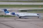
Mark Pasqualino
@ KORD

Mark Pasqualino
@ KORD

Mark Pasqualino
@ KORD

Mark Pasqualino
@ KORD
Recent Routes
NO LIVE DATA
GoJet Airlines
| Time | Callsign | FL | Speed | Heading | Route |
|---|---|---|---|---|---|
| 2026-11-20 05:18 UTC | GJS4461 / G74461 | FL17 | 117 kt | 55° | — |
| 2026-11-20 00:10 UTC | GJS4405 / G74405 | — | 13 kt | 270° |
ORD → SGF
ORD
→
SGF
Chicago O'hare International Airport → Springfield-branson Ntl Airport |
| 2026-11-19 20:36 UTC | GJS4582 / G74582 | FL0 | 131 kt | 147° | — |
| 2026-11-19 18:08 UTC | GJS4431 / G74431 | — | 4 kt | 301° |
TN98 → EWR
TN98
→
EWR
Sky Ranch Airport → Newark Liberty International Airport |
| 2026-11-19 15:24 UTC | GJS4178 / G74178 | FL8 | 122 kt | 45° |
EWR → TYS
EWR
→
TYS
Newark Liberty International Airport → Mc Ghee Tyson Airport |
| 2026-11-19 12:48 UTC | GJS4595 / G74595 | — | 1 kt | 194° | — |
| 2026-11-19 01:44 UTC | GJS4415 / G74415 | FL257 | 122 kt | 180° | — |
| 2026-11-18 21:48 UTC | GJS4462 / G74462 | — | 11 kt | 188° |
EWR → DCA
EWR
→
DCA
Newark Liberty International Airport → Ronald Reagan Washington Ntl Airport |
| 2026-11-18 18:30 UTC | GJS4580 / G74580 | FL54 | 232 kt | 259° | — |
| 2026-11-18 16:28 UTC | GJS4383 / G74383 | — | 6 kt | 188° |
CVG → EWR
CVG
→
EWR
Cincinnati/northern Kentucky International Airport → Newark Liberty International Airport |
| 2026-11-18 13:22 UTC | GJS4167 / G74167 | FL5 | 121 kt | 180° |
EWR → CVG
EWR
→
CVG
Newark Liberty International Airport → Cincinnati/northern Kentucky International Airport |
| 2026-11-18 00:20 UTC | GJS4489 / G74489 | — | 10 kt | 203° | — |
| 2026-11-17 20:48 UTC | GJS4450 / G74450 | FL22 | 125 kt | 160° | — |
| 2026-11-17 18:26 UTC | GJS4475 / G74475 | — | 2 kt | 301° | — |
| 2026-11-17 15:46 UTC | GJS4495 / G74495 | FL2 | 130 kt | 209° |
EWR → DTW
EWR
→
DTW
Newark Liberty International Airport → Detroit Metro Wayne County Airport |
| 2026-11-17 03:26 UTC | GJS4389 / G74389 | — | 0 kt | 188° | — |
| 2026-11-17 01:40 UTC | GJS4570 / G74570 | FL4 | 125 kt | 224° |
EWR → BUF
EWR
→
BUF
Newark Liberty International Airport → Buffalo Niagara International Airport |
| 2026-11-16 22:08 UTC | GJS4413 / G74413 | — | 11 kt | 183° |
DCA → EWR
DCA
→
EWR
Ronald Reagan Washington Ntl Airport → Newark Liberty International Airport |
| 2026-11-16 19:50 UTC | GJS4433 / G74433 | — | 8 kt | 172° |
EWR → DCA
EWR
→
DCA
Newark Liberty International Airport → Ronald Reagan Washington Ntl Airport |
| 2026-11-16 15:26 UTC | GJS4390 / G74390 | FL10 | 132 kt | 272° | — |
| 2026-11-16 12:00 UTC | GJS4542 / G74542 | — | 4 kt | 357° | — |
| 2026-11-16 05:26 UTC | GJS4577 / G74577 | FL12 | 118 kt | 275° |
PHL → IAD
PHL
→
IAD
Philadelphia International Airport → Washington Dulles International Airport |
| 2026-11-16 02:50 UTC | GJS4541 / G74541 | — | 13 kt | 349° |
IAD → BUF
IAD
→
BUF
Washington Dulles International Airport → Buffalo Niagara International Airport |
| 2026-11-16 00:44 UTC | GJS4575 / G74575 | FL0 | 133 kt | 212° |
PHL → IAD
PHL
→
IAD
Philadelphia International Airport → Washington Dulles International Airport |
| 2026-11-15 20:20 UTC | GJT4575 | — | 8 kt | 239° | — |
| 2026-11-15 19:32 UTC | GJT4430 | — | 8 kt | 219° |
IAD → PHL
IAD
→
PHL
Washington Dulles International Airport → Philadelphia International Airport |
| 2026-11-15 17:36 UTC | GJS4544 / G74544 | — | 0 kt | 20° |
IAD → CVG
IAD
→
CVG
Washington Dulles International Airport → Cincinnati/northern Kentucky International Airport |
| 2026-11-15 15:24 UTC | GJS4503 / G74503 | FL3 | 123 kt | 321° | — |
| 2026-11-15 12:10 UTC | GJT4542 | — | 4 kt | 211° | — |
| 2026-11-15 00:22 UTC | GJS4498 / G74498 | FL16 | 135 kt | 275° | — |
| 2026-11-14 21:52 UTC | GJS4560 / G74560 | — | 0 kt | 298° |
DCA → EWR
DCA
→
EWR
Ronald Reagan Washington Ntl Airport → Newark Liberty International Airport |
| 2026-11-14 19:14 UTC | GJS4499 / G74499 | — | 80 kt | 349° |
EWR → DCA
EWR
→
DCA
Newark Liberty International Airport → Ronald Reagan Washington Ntl Airport |
| 2026-11-14 16:30 UTC | GJS3383 / G73383 | — | 1 kt | 304° | — |
| 2026-11-13 12:22 UTC | GJS4494 / G74494 | — | 6 kt | 326° |
PHL → IAD
PHL
→
IAD
Philadelphia International Airport → Washington Dulles International Airport |
| 2026-11-13 04:40 UTC | GJS4558 / G74558 | — | 4 kt | 0° |
IAD → PHL
IAD
→
PHL
Washington Dulles International Airport → Philadelphia International Airport |
| 2026-11-13 02:02 UTC | GJS4189 / G74189 | — | 0 kt | 357° | — |
| 2026-11-13 00:18 UTC | GJS4548 / G74548 | FL9 | 101 kt | 217° |
IAD → ORF
IAD
→
ORF
Washington Dulles International Airport → Norfolk International Airport |
| 2026-11-12 18:32 UTC | GJS4430 / G74430 | — | 13 kt | 84° |
IAD → PHL
IAD
→
PHL
Washington Dulles International Airport → Philadelphia International Airport |
| 2026-11-12 16:32 UTC | GJS4402 / G74402 | — | 10 kt | 298° |
PHL → IAD
PHL
→
IAD
Philadelphia International Airport → Washington Dulles International Airport |
| 2026-11-12 02:30 UTC | GJS4400 / G74400 | FL26 | 217 kt | 120° | — |
| 2026-11-11 23:40 UTC | GJS4179 / G74179 | — | 9 kt | 68° | — |
| 2026-11-11 20:00 UTC | GJS4601 / G74601 | FL16 | 139 kt | 202° |
STL → ORD
STL
→
ORD
St Louis Lambert International Airport → Chicago O'hare International Airport |
| 2026-11-11 17:26 UTC | GS4529 / GS4529 | — | 12 kt | 3° | — |
| 2026-11-11 01:50 UTC | GJS4507 / G74507 | FL38 | 164 kt | 340° | — |
| 2026-11-10 22:44 UTC | GJS4391 / G74391 | — | 19 kt | 90° | — |
| 2026-11-10 20:16 UTC | GJS4531 / G74531 | FL13 | 131 kt | 160° | — |
| 2026-11-10 17:58 UTC | GJS4616 / G74616 | — | 9 kt | 177° |
STL → ORD
STL
→
ORD
St Louis Lambert International Airport → Chicago O'hare International Airport |
| 2026-11-10 15:56 UTC | GJS4551 / G74551 | FL9 | 131 kt | 271° |
FSD → ORD
FSD
→
ORD
Joe Foss Fld Airport → Chicago O'hare International Airport |
| 2026-11-10 13:50 UTC | GJS4537 / G74537 | — | 16 kt | 87° |
ROA → ORD
ROA
→
ORD
Roanoke/blacksburg Regional (woodrum Fld) Airport → Chicago O'hare International Airport |
| 2026-11-10 01:36 UTC | GJS4394 / G74394 | — | 16 kt | 146° |
ORD → ROA
ORD
→
ROA
Chicago O'hare International Airport → Roanoke/blacksburg Regional (woodrum Fld) Airport |
| 2026-11-09 23:06 UTC | GJS4488 / G74488 | — | 15 kt | 177° |
FSD → ORD
FSD
→
ORD
Joe Foss Fld Airport → Chicago O'hare International Airport |
| 2026-11-09 20:28 UTC | GJS4572 / G74572 | — | 7 kt | 203° |
ORD → FSD
ORD
→
FSD
Chicago O'hare International Airport → Joe Foss Fld Airport |
| 2026-11-09 14:56 UTC | GJS4613 / G74613 | — | 0 kt | 191° |
ORD → STL
ORD
→
STL
Chicago O'hare International Airport → St Louis Lambert International Airport |
| 2026-11-09 12:18 UTC | GJS4439 / G74439 | — | 16 kt | 270° |
STL → ORD
STL
→
ORD
St Louis Lambert International Airport → Chicago O'hare International Airport |
| 2026-11-09 05:20 UTC | GJS4425 / G74425 | — | 13 kt | 141° | — |
| 2026-11-08 21:14 UTC | GJS4615 / G74615 | FL2 | 128 kt | 90° | — |
| 2026-11-08 19:06 UTC | GJS4532 / G74532 | FL1 | 131 kt | 43° | — |
| 2026-11-08 16:42 UTC | GJS4181 / G74181 | FL2 | 129 kt | 89° | — |
| 2026-11-08 14:34 UTC | GJS4586 / G74586 | FL0 | 122 kt | 44° | — |
| 2026-11-08 12:26 UTC | GJS4419 / G74419 | FL2 | 131 kt | 90° | — |
| 2026-11-08 03:06 UTC | GJS4599 / G74599 | FL3 | 122 kt | 136° | — |
| 2026-11-07 22:56 UTC | GJS4573 / G74573 | FL5 | 127 kt | 90° | — |
| 2026-11-07 20:44 UTC | GJS4393 / G74393 | FL12 | 133 kt | 3° | — |
| 2026-11-07 18:04 UTC | GJS4453 / G74453 | — | 10 kt | 62° | — |
| 2026-11-07 16:12 UTC | GJS4566 / G74566 | FL9 | 116 kt | 235° |
ORD → DAY
ORD
→
DAY
Chicago O'hare International Airport → James M Cox Dayton International Airport |
| 2026-11-07 05:02 UTC | GJS4447 / G74447 | — | 6 kt | 129° |
ORD → FSD
ORD
→
FSD
Chicago O'hare International Airport → Joe Foss Fld Airport |
| 2026-11-07 01:48 UTC | GJS4534 / G74534 | — | 14 kt | 242° | — |
| 2026-11-06 22:20 UTC | GJS4429 / G74429 | FL19 | 127 kt | 3° | — |
| 2026-11-06 19:00 UTC | GJS4579 / G74579 | FL4 | 137 kt | 269° | — |
| 2026-11-06 17:02 UTC | GJS4392 / G74392 | FL2 | 130 kt | 43° | — |
| 2026-11-06 14:04 UTC | GJS4456 / G74456 | FL4 | 127 kt | 270° | — |
| 2026-11-06 03:30 UTC | GJS4588 / G74588 | FL2 | 122 kt | 314° | — |
| 2026-11-06 00:26 UTC | GJS4528 / G74528 | FL5 | 139 kt | 270° |
STL → ORD
STL
→
ORD
St Louis Lambert International Airport → Chicago O'hare International Airport |
| 2026-11-05 20:12 UTC | GJS4426 / G74426 | FL9 | 136 kt | 0° |
IAD → HSV
IAD
→
HSV
Washington Dulles International Airport → Huntsville Intl-carl T Jones Fld Airport |
| 2026-11-04 23:06 UTC | GJS4437 / G74437 | — | 16 kt | 87° | — |
| 2026-11-04 21:12 UTC | GJS4546 / G74546 | FL13 | 121 kt | 261° | — |
| 2026-11-04 17:28 UTC | GJS4451 / G74451 | — | 20 kt | 90° |
GSP → ORD
GSP
→
ORD
Greenville Spartanburg International Airport → Chicago O'hare International Airport |
| 2026-11-04 14:18 UTC | GJS4521 / G74521 | FL8 | 126 kt | 32° | — |
| 2026-11-04 02:16 UTC | GJS4617 / G74617 | — | 12 kt | 357° | — |
| 2026-11-03 23:48 UTC | GJS4481 / G74481 | FL36 | 140 kt | 3° | — |
| 2026-11-03 20:34 UTC | GJS3377 / G73377 | — | 13 kt | 242° | — |
| 2026-11-02 13:14 UTC | GJS4515 / G74515 | — | 2 kt | 194° |
DCA → EWR
DCA
→
EWR
Ronald Reagan Washington Ntl Airport → Newark Liberty International Airport |
| 2026-11-01 17:06 UTC | GJS4446 / G74446 | — | 8 kt | 183° |
DCA → EWR
DCA
→
EWR
Ronald Reagan Washington Ntl Airport → Newark Liberty International Airport |
| 2026-11-01 15:00 UTC | GJS4444 / G74444 | — | 14 kt | 172° |
EWR → DCA
EWR
→
DCA
Newark Liberty International Airport → Ronald Reagan Washington Ntl Airport |
| 2026-11-01 12:24 UTC | GJS4480 / G74480 | — | 10 kt | 219° | — |
| 2026-10-31 22:58 UTC | GJS4468 / G74468 | FL4 | 121 kt | 224° |
IAD → BUF
IAD
→
BUF
Washington Dulles International Airport → Buffalo Niagara International Airport |
| 2026-10-31 20:30 UTC | GJS4449 / G74449 | — | 3 kt | 132° | — |
| 2026-10-31 02:30 UTC | GJS403A / G7403A | — | 18 kt | 87° | — |
| 2026-10-30 23:28 UTC | GJS4482 / G74482 | FL16 | 135 kt | 105° | — |
| 2026-10-30 20:22 UTC | GJS4432 / G74432 | — | 12 kt | 0° |
EWR → DCA
EWR
→
DCA
Newark Liberty International Airport → Ronald Reagan Washington Ntl Airport |
| 2026-10-30 17:10 UTC | GJS4608 / G74608 | FL9 | 128 kt | 33° |
ROC → IAD
ROC
→
IAD
Frederick Douglass/greater Rochester International Airport → Washington Dulles International Airport |
| 2026-10-30 14:04 UTC | GJS4421 / G74421 | — | 10 kt | 357° |
SGF → ORD
SGF
→
ORD
Springfield-branson Ntl Airport → Chicago O'hare International Airport |
| 2026-10-29 20:26 UTC | GJS4501 / G74501 | FL85 | 297 kt | 81° |
ORD → 5PA8
ORD
→
5PA8
Chicago O'hare International Airport → Conshohocken Heliport |
| 2026-10-29 17:14 UTC | GJS4464 / G74464 | — | 21 kt | 87° | — |
| 2026-10-29 14:42 UTC | GJS4435 / G74435 | FL16 | 121 kt | 233° | — |
| 2026-10-29 11:42 UTC | GJS4438 / G74438 | — | 10 kt | 180° | — |
| 2026-10-29 00:32 UTC | GJS4171 / G74171 | FL72 | 251 kt | 77° | — |
| 2026-10-28 21:54 UTC | GJS4543 / G74543 | — | 20 kt | 90° | — |
| 2026-10-28 19:12 UTC | GJS4535 / G74535 | FL12 | 137 kt | 272° |
IAH → HSV
IAH
→
HSV
George Bush Intcntl/houston Airport → Huntsville Intl-carl T Jones Fld Airport |
| 2026-10-28 16:46 UTC | GJS4397 / G74397 | — | 10 kt | 242° |
CAE → ORD
CAE
→
ORD
Columbia Metro Airport → Chicago O'hare International Airport |
| 2026-10-27 21:20 UTC | GJS4182 / G74182 | — | 16 kt | 174° |
LIT → ORD
LIT
→
ORD
Bill And Hillary Clinton Ntl/adams Fld Airport → Chicago O'hare International Airport |
| 2026-10-27 18:22 UTC | GJS4565 / G74565 | — | 13 kt | 295° | — |
| 2026-10-27 12:52 UTC | GJS4600 / G74600 | FL3 | 121 kt | 90° |
IAH → CRP
IAH
→
CRP
George Bush Intcntl/houston Airport → Corpus Christi International Airport |
| 2026-10-27 02:46 UTC | GJS4471 / G74471 | — | 26 kt | 143° | — |
| 2026-10-26 21:14 UTC | GJS4596 / G74596 | FL10 | 131 kt | 142° | — |
| 2026-10-26 18:14 UTC | GJS4564 / G74564 | FL2 | 131 kt | 90° | — |
| 2026-10-26 16:02 UTC | GJS4526 / G74526 | FL3 | 127 kt | 39° | — |
| 2026-10-25 23:24 UTC | GJS4380 / G74380 | FL2 | 127 kt | 89° | — |
| 2026-10-25 20:42 UTC | GJS4533 / G74533 | FL-1 | 121 kt | 347° | — |
| 2026-10-24 21:58 UTC | GJS4552 / G74552 | FL4 | 125 kt | 89° | — |
| 2026-10-24 17:14 UTC | GJS4517 / G74517 | — | 19 kt | 87° | — |
| 2026-10-24 14:14 UTC | GJS4518 / G74518 | — | 0 kt | 158° |
ORD → STL
ORD
→
STL
Chicago O'hare International Airport → St Louis Lambert International Airport |
| 2026-10-23 20:12 UTC | GJS4505 / G74505 | — | 3 kt | 357° |
ORD → HSV
ORD
→
HSV
Chicago O'hare International Airport → Huntsville Intl-carl T Jones Fld Airport |
| 2026-10-23 14:34 UTC | GJS4452 / G74452 | — | 10 kt | 17° | — |
| 2026-10-23 00:34 UTC | GJS4386 / G74386 | FL12 | 130 kt | 327° | — |
| 2026-10-22 21:56 UTC | GJS4466 / G74466 | — | 4 kt | 307° | — |
| 2026-10-22 19:38 UTC | GJS4463 / G74463 | FL9 | 125 kt | 32° |
ORD → ABE
ORD
→
ABE
Chicago O'hare International Airport → Lehigh Valley International Airport |
| 2026-10-21 22:22 UTC | GJS4454 / G74454 | — | 9 kt | 239° | — |
| 2026-10-21 15:04 UTC | GJS4192 / G74192 | — | 7 kt | 293° |
RIC → EWR
RIC
→
EWR
Richmond International Airport → Newark Liberty International Airport |
Live location data from OpenSky Network
Airframe Info
| Manufacturer | Bombardier |
| Model | CRJ-701ER (CL-600-2C10) Regional Jet Search all Bombardier CRJ-701ER (CL-600-2C10) Regional Jet |
| Year built | 2006 |
| Construction Number (C/N) | 10256 |
| Aircraft Type | Fixed wing multi engine |
| Number of Engines | 2 |
| Engine Type | Turbofan |
| Engine Manufacturer and Model | GE CF34-8C1 |
Aircraft
| Registration Number | N543GJ |
| Mode S (ICAO24) Code | a6e3b0 |
| Certification Class | Standard |
| Certification Issued | 2020-10-29 |
| Air Worthiness Test | 2019-10-21 |
| Last Action Taken | 2023-03-24 |
| Current Status | Valid |
| Delivery Date | 2006-04-28 |
Owner
| Registration Type | Corporation |
| Owner | SKYWEST AIRLINES INC |
| Address |
St George, UT 847902085 United States |
| Region | Northwest Mountain |