Aircraft N601LR Data
1
aircraft record found
N601LR
2007 Bombardier CRJ-900ER (CL-600-2D24), c/n 15145
Latest photos of N601LR
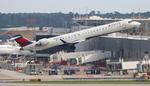
FloridaMetal
@ KATL
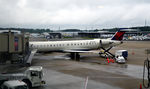
Ronald Barker
@ KRIC
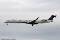
Dariusz Jezewski www.FotoDj.com
@ CYUL
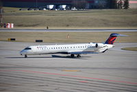
Christian Maurer
@ CVG
Recent Routes
NO LIVE DATA
| Time | Callsign | FL | Speed | Heading | Route |
|---|---|---|---|---|---|
| 2026-10-23 22:16 UTC | EDV4949 | FL8 | 139 kt | 0° | — |
| 2026-10-23 19:16 UTC | EDV5362 | — | 2 kt | 309° | — |
| 2026-10-23 14:58 UTC | EDV4631 | — | 1 kt | 298° | — |
| 2026-10-23 00:06 UTC | EDV4630 | FL8 | 140 kt | 183° | — |
| 2026-10-22 19:50 UTC | EDV4719 | — | 8 kt | 191° |
YUL → LGA
YUL
→
LGA
Montreal / Pierre Elliott Trudeau International Airport → Laguardia Airport |
| 2026-10-22 17:06 UTC | EDV4751 | — | 15 kt | 222° |
LGA → YUL
LGA
→
YUL
Laguardia Airport → Montreal / Pierre Elliott Trudeau International Airport |
| 2026-10-22 14:54 UTC | EDV5139 | — | 0 kt | 129° |
YUL → LGA
YUL
→
LGA
Montreal / Pierre Elliott Trudeau International Airport → Laguardia Airport |
| 2026-10-22 12:18 UTC | EDV4963 | — | 10 kt | 127° |
LGA → YUL
LGA
→
YUL
Laguardia Airport → Montreal / Pierre Elliott Trudeau International Airport |
| 2026-10-22 02:52 UTC | EDV5017 | — | 8 kt | 219° |
BNA → LGA
BNA
→
LGA
Nashville International Airport → Laguardia Airport |
| 2026-10-21 23:24 UTC | EDV5152 | — | 4 kt | 149° | — |
| 2026-10-21 20:46 UTC | EDV5281 | FL4 | 136 kt | 45° | — |
| 2026-10-21 18:18 UTC | EDV4641 | FL6 | 141 kt | 45° | — |
| 2026-10-21 16:36 UTC | EDV4629 | FL5 | 139 kt | 29° | — |
| 2026-10-21 14:58 UTC | EDV4968 | FL6 | 135 kt | 0° | — |
| 2026-10-21 11:40 UTC | EDV5355 | — | 0 kt | 293° | — |
| 2026-10-21 02:46 UTC | EDV5524 | FL47 | 245 kt | 22° | — |
| 2026-10-21 00:58 UTC | EDV5038 | — | 0 kt | 312° | — |
| 2026-10-20 23:24 UTC | EDVM0 | FL350 | 471 kt | 77° | — |
| 2026-10-20 21:56 UTC | EDV5261 | FL38 | 149 kt | 340° | — |
| 2026-10-20 20:14 UTC | EDV4953 | — | 10 kt | 357° |
ATL → KM95
ATL
→
KM95
Hartsfield/jackson Atlanta International Airport → Richard Arthur Fld Airport |
| 2026-10-20 16:22 UTC | EDV4649 | — | 1 kt | 267° |
ROA → ATL
ROA
→
ATL
Roanoke/blacksburg Regional (woodrum Fld) Airport → Hartsfield/jackson Atlanta International Airport |
| 2026-10-20 14:06 UTC | EDV4628 | — | 14 kt | 239° |
ATL → ROA
ATL
→
ROA
Hartsfield/jackson Atlanta International Airport → Roanoke/blacksburg Regional (woodrum Fld) Airport |
| 2026-10-20 11:54 UTC | EDV4912 | — | 0 kt | 273° |
DHN → ATL
DHN
→
ATL
Dothan Regional Airport → Hartsfield/jackson Atlanta International Airport |
| 2026-10-20 01:40 UTC | EDV4910 | — | 15 kt | 132° |
ATL → DHN
ATL
→
DHN
Hartsfield/jackson Atlanta International Airport → Dothan Regional Airport |
| 2026-10-19 22:50 UTC | EDV5389 | — | 2 kt | 270° |
ATL → BMI
ATL
→
BMI
Hartsfield/jackson Atlanta International Airport → Central Il Rgnl/bloomington-normal Airport |
| 2026-10-19 18:14 UTC | EDV5425 | — | 12 kt | 335° | — |
| 2026-10-19 14:40 UTC | EDV5475 | — | 1 kt | 307° | — |
| 2026-10-19 08:56 UTC | EDV5379 | — | 10 kt | 180° | — |
| 2026-10-18 16:58 UTC | EDV5001 | — | 2 kt | 267° | — |
| 2026-10-18 12:00 UTC | EDV4691 | — | 0 kt | 295° |
ABY → ATL
ABY
→
ATL
Southwest Georgia Regional Airport → Hartsfield/jackson Atlanta International Airport |
| 2026-10-18 01:24 UTC | EDV5129 | — | 0 kt | 233° |
ATL → ABY
ATL
→
ABY
Hartsfield/jackson Atlanta International Airport → Southwest Georgia Regional Airport |
| 2026-10-17 22:42 UTC | EDV5227 | — | 3 kt | 96° |
ATL → ROA
ATL
→
ROA
Hartsfield/jackson Atlanta International Airport → Roanoke/blacksburg Regional (woodrum Fld) Airport |
| 2026-10-17 19:14 UTC | EDV4955 | — | 19 kt | 270° | — |
| 2026-10-17 15:40 UTC | EDV5111 | — | 2 kt | 87° | — |
| 2026-10-17 10:54 UTC | EDV5403 | — | 4 kt | 273° |
CSG → ATL
CSG
→
ATL
Columbus Airport → Hartsfield/jackson Atlanta International Airport |
| 2026-10-17 01:30 UTC | EDV5429 | FL9 | 142 kt | 234° | — |
| 2026-10-16 23:30 UTC | EDV5377 | — | 12 kt | 87° | — |
| 2026-10-16 19:56 UTC | EDV5288 | — | 2 kt | 270° | — |
| 2026-10-16 16:24 UTC | EDV5372 | — | 4 kt | 270° | — |
| 2026-10-16 12:54 UTC | EDV5225 | — | 3 kt | 270° | — |
| 2026-10-16 01:16 UTC | EDV5246 | FL2 | 159 kt | 348° | — |
| 2026-10-15 23:04 UTC | EDV5528 | — | 0 kt | 79° | — |
| 2026-10-15 18:54 UTC | EDV5312 | — | 3 kt | 253° | — |
| 2026-10-15 15:06 UTC | EDV5513 | — | 9 kt | 180° | — |
| 2026-10-15 10:46 UTC | EDVM951 | — | 1 kt | 278° | — |
| 2026-10-14 18:00 UTC | EDV5062 | — | 13 kt | 180° | — |
| 2026-10-14 12:44 UTC | EDV5383 | — | 0 kt | 270° |
BMI → ATL
BMI
→
ATL
Central Il Rgnl/bloomington-normal Airport → Hartsfield/jackson Atlanta International Airport |
| 2026-10-14 03:56 UTC | EDV5410 | — | 5 kt | 290° |
ATL → BMI
ATL
→
BMI
Hartsfield/jackson Atlanta International Airport → Central Il Rgnl/bloomington-normal Airport |
| 2026-10-14 01:42 UTC | EDV5059 | — | 1 kt | 90° | — |
| 2026-10-13 20:48 UTC | EDV5519 | — | 21 kt | 87° | — |
| 2026-10-13 12:22 UTC | EDV5337 | — | 15 kt | 0° | — |
| 2026-10-13 04:06 UTC | EDV5375 | FL19 | 148 kt | 276° | — |
| 2026-10-12 23:58 UTC | EDV4958 | — | 0 kt | 278° | — |
| 2026-10-12 18:10 UTC | EDV4707 | — | 22 kt | 87° | — |
| 2026-10-12 12:50 UTC | EDV5525 | — | 2 kt | 87° | — |
| 2026-10-12 02:46 UTC | EDV5535 | FL24 | 182 kt | 219° | — |
| 2026-10-12 00:36 UTC | EDV5278 | — | 0 kt | 293° | — |
| 2026-10-11 22:46 UTC | EDV4665 | FL40 | 138 kt | 340° | — |
| 2026-10-11 20:04 UTC | EEV5391 | — | 4 kt | 290° | — |
| 2026-10-11 17:24 UTC | EDV5423 | FL103 | 310 kt | 52° | — |
| 2026-10-11 09:08 UTC | EDV5013 | — | 1 kt | 267° | — |
| 2026-10-10 13:44 UTC | EDV5255 | — | 8 kt | 28° | — |
| 2026-10-10 01:54 UTC | EDV5443 | FL26 | 190 kt | 79° | — |
| 2026-10-09 23:56 UTC | EDV4633 | — | 1 kt | 270° | — |
| 2026-10-09 18:34 UTC | EDV4686 | — | 2 kt | 270° | — |
| 2026-10-09 00:46 UTC | EDV5282 | — | 17 kt | 87° | — |
| 2026-10-08 21:06 UTC | EDV5466 | — | 22 kt | 87° | — |
| 2026-10-08 16:30 UTC | EDV5236 | — | 1 kt | 309° | — |
| 2026-10-08 12:48 UTC | EDV4940 | — | 1 kt | 287° | — |
| 2026-10-08 02:40 UTC | EDV5452 | FL147 | 373 kt | 260° | — |
| 2026-10-07 23:44 UTC | EDV5529 | — | 4 kt | 270° | — |
| 2026-10-07 18:52 UTC | EDV4650 | — | 6 kt | 183° | — |
| 2026-10-07 13:52 UTC | EDV5234 | — | 0 kt | 267° | — |
| 2026-10-07 01:46 UTC | EDV5203 | FL16 | 145 kt | 225° | — |
| 2026-10-06 12:04 UTC | EDV4632 | — | 0 kt | 110° | — |
| 2026-10-06 03:06 UTC | EDV4657 | FL54 | 254 kt | 346° | — |
| 2026-10-06 00:02 UTC | EDV5115 | — | 15 kt | 357° | — |
| 2026-10-05 20:06 UTC | EDV5042 | — | 6 kt | 28° |
LGA → RDU
LGA
→
RDU
Laguardia Airport → Raleigh-durham International Airport |
| 2026-10-04 12:34 UTC | EDV4957 | — | 6 kt | 163° |
ABE → ATL
ABE
→
ATL
Lehigh Valley International Airport → Hartsfield/jackson Atlanta International Airport |
| 2026-10-04 02:04 UTC | EDV4995 | — | 7 kt | 231° |
ATL → ABE
ATL
→
ABE
Hartsfield/jackson Atlanta International Airport → Lehigh Valley International Airport |
| 2026-10-01 14:16 UTC | EDV5497 | — | 0 kt | 309° | — |
| 2026-10-01 02:54 UTC | EDV5159 | FL15 | 135 kt | 159° |
GRB → MSP
GRB
→
MSP
Green Bay/austin Straubel International Airport → Minneapolis-st Paul Intl/wold-chamberlain Airport |
| 2026-09-30 19:20 UTC | EDV4952 | — | 2 kt | 267° |
BMI → ATL
BMI
→
ATL
Central Il Rgnl/bloomington-normal Airport → Hartsfield/jackson Atlanta International Airport |
| 2026-09-30 14:56 UTC | EDV5143 | — | 17 kt | 87° | — |
| 2026-09-30 11:24 UTC | EDV4661 | — | 0 kt | 278° | — |
| 2026-09-30 03:06 UTC | EDV4669 | FL10 | 146 kt | 47° | — |
| 2026-09-30 00:10 UTC | EDV4993 | — | 3 kt | 270° | — |
| 2026-09-29 20:06 UTC | EDV5271 | — | 1 kt | 79° | — |
| 2026-09-29 17:32 UTC | EDV5323 | FL56 | 259 kt | 239° | — |
| 2026-09-29 15:30 UTC | EDV5274 | — | 9 kt | 222° | — |
| 2026-09-29 13:02 UTC | EDV5392 | FL7 | 128 kt | 230° | — |
| 2026-09-28 23:38 UTC | EDV4980 | FL7 | 139 kt | 29° | — |
| 2026-09-28 21:16 UTC | EDV5406 | FL5 | 0 kt | 115° | — |
| 2026-09-28 18:38 UTC | EDV4964 | FL7 | 141 kt | 28° | — |
| 2026-09-28 12:56 UTC | EDV5092 | FL7 | 140 kt | 29° | — |
| 2026-09-28 01:34 UTC | EDV5293 | FL6 | 150 kt | 327° | — |
| 2026-09-27 22:06 UTC | EDV5289 | FL4 | 132 kt | 31° |
ROC → JFK
ROC
→
JFK
Frederick Douglass/greater Rochester International Airport → John F Kennedy International Airport |
| 2026-09-27 19:42 UTC | EDV5211 | — | 1 kt | 56° | — |
| 2026-09-27 17:46 UTC | EDV5303 | FL7 | 137 kt | 29° | — |
| 2026-09-27 16:08 UTC | EDV5086 | FL14 | 131 kt | 317° | — |
| 2026-09-27 12:58 UTC | EDV5008 | FL5 | 108 kt | 31° |
CLE → JFK
CLE
→
JFK
Cleveland-hopkins International Airport → John F Kennedy International Airport |
| 2026-09-27 02:54 UTC | EDV4946 | FL7 | 137 kt | 50° |
JFK → CLE
JFK
→
CLE
John F Kennedy International Airport → Cleveland-hopkins International Airport |
| 2026-09-26 22:56 UTC | EDV5027 | FL4 | 118 kt | 31° | — |
| 2026-09-26 20:18 UTC | EDV4971 | FL13 | 132 kt | 316° | — |
| 2026-09-26 17:24 UTC | EDV4705 | — | 0 kt | 194° | — |
| 2026-09-26 12:50 UTC | EDV5248 | — | 1 kt | 211° | — |
| 2026-09-26 04:06 UTC | EDV5290 | FL9 | 127 kt | 90° | — |
| 2026-09-26 02:18 UTC | EDV4947 | — | 3 kt | 208° |
ABE → ATL
ABE
→
ATL
Lehigh Valley International Airport → Hartsfield/jackson Atlanta International Airport |
| 2026-09-25 15:30 UTC | EDV5325 | — | 0 kt | 211° |
STL → MSP
STL
→
MSP
St Louis Lambert International Airport → Minneapolis-st Paul Intl/wold-chamberlain Airport |
| 2026-09-25 13:04 UTC | EDV4939 | — | 0 kt | 236° |
LGA → STL
LGA
→
STL
Laguardia Airport → St Louis Lambert International Airport |
| 2026-09-25 02:06 UTC | EDV5047 | — | 0 kt | 326° |
LGA → CLT
LGA
→
CLT
Laguardia Airport → Charlotte/douglas International Airport |
| 2026-09-24 20:10 UTC | EDV5156 | — | 7 kt | 222° | — |
| 2026-09-24 12:44 UTC | EDV5093 | — | 8 kt | 219° | — |
| 2026-09-24 02:06 UTC | EDV5433 | FL3 | 127 kt | 328° | — |
Live location data from OpenSky Network
Airframe Info
| Manufacturer | Bombardier |
| Model | CRJ-900ER (CL-600-2D24) Search all Bombardier CRJ-900ER (CL-600-2D24) |
| Year built | 2007 |
| Construction Number (C/N) | 15145 |
| Aircraft Type | Fixed wing multi engine |
| Number of Seats | 22 |
| Number of Engines | 2 |
| Engine Type | Turbofan |
| Engine Manufacturer and Model | General Electric CF34-8C5 |
Aircraft
| Registration Number | N601LR |
| Mode S (ICAO24) Code | a7cc00 |
| Certification Class | Standard |
| Certification Issued | 2007-10-18 |
| Air Worthiness Test | 2007-10-18 |
| Last Action Taken | 2023-06-03 |
| Current Status | Valid |
Owner
| Registration Type | Corporation |
| Owner | DELTA AIR LINES INC |
| Address |
Dept 595 Aircraft Registrations Atlanta, GA 30354 United States |
| Region | Southern |