N644AE — 1999 Embraer ERJ-145LR (EMB-145LR) Data
1
aircraft record found
N644AE
1999 Embraer ERJ-145LR (EMB-145LR), c/n 145204
N644AE is a 1999 Embraer ERJ-145LR (EMB-145LR) (serial number 145204). It is configured with 2 engines and 55 seats. Registration status is listed as Valid, with ownership recorded under AMERICAN AIRLINES INC in Fort Worth, TX, United States. The profile includes 20 photos documenting this aircraft.
Latest photos of N644AE

Mark Pasqualino
@ KORD

Dariusz Jezewski www.FotoDj.com
@ KJFK
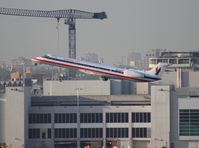
Florida Metal
@ MIA

Florida Metal
@ MIA
Recent Routes
NO LIVE DATA
Piedmont Airlines (1948-1989)
| Time | Callsign | FL | Speed | Heading | Route |
|---|---|---|---|---|---|
| 2026-11-20 05:18 UTC | PDT6065 / PI6065 | FL4 | 135 kt | 181° | — |
| 2026-11-20 02:14 UTC | PDT5929 / PI5929 | FL8 | 127 kt | 356° | — |
| 2026-11-19 21:58 UTC | PDT5941 / PI5941 | FL6 | 128 kt | 356° | — |
| 2026-11-19 18:16 UTC | PDT5985 / PI5985 | FL7 | 134 kt | 357° |
CLT → K6L4
CLT
→
K6L4
Charlotte/douglas International Airport → Logan County Airport |
| 2026-11-19 14:22 UTC | PDT6075 / PI6075 | FL7 | 135 kt | 356° | — |
| 2026-11-19 03:32 UTC | PDT5943 / PI5943 | — | 17 kt | 149° | — |
| 2026-11-19 01:12 UTC | PDT6039 / PI6039 | FL7 | 126 kt | 357° | — |
| 2026-11-18 20:46 UTC | PDT6000 / PI6000 | FL4 | 140 kt | 356° | — |
| 2026-11-18 16:04 UTC | PDT5852 / PI5852 | FL168 | 135 kt | 356° | — |
| 2026-11-18 12:04 UTC | PDT5975 / PI5975 | FL7 | 127 kt | 356° | — |
| 2026-11-18 01:22 UTC | PDT5948 / PI5948 | FL14 | 153 kt | 28° | — |
| 2026-11-17 23:14 UTC | PDT5950 / PI5950 | — | 123 kt | 355° | — |
| 2026-11-17 18:12 UTC | PDT5793 / PI5793 | FL6 | 130 kt | 356° | — |
| 2026-11-17 14:10 UTC | PDT5956 / PI5956 | FL2 | 126 kt | 356° | — |
| 2026-11-17 03:40 UTC | PDT5818 / PI5818 | FL84 | 138 kt | 104° | — |
| 2026-11-17 01:26 UTC | PDT6002 / PI6002 | FL3 | 124 kt | 356° | — |
| 2026-11-16 20:48 UTC | PDT6060 / PI6060 | FL4 | 143 kt | 356° | — |
| 2026-11-16 17:04 UTC | PDT6093 / PI6093 | FL3 | 145 kt | 356° | — |
| 2026-11-16 11:50 UTC | PDT5845 / PI5845 | FL7 | 122 kt | 356° | — |
| 2026-11-16 04:32 UTC | PDT5912 / PI5912 | FL39 | 186 kt | 312° | — |
| 2026-11-16 02:24 UTC | PDT5971 / PI5971 | FL5 | 130 kt | 356° | — |
| 2026-11-15 20:28 UTC | PDT5984 / PI5984 | FL8 | 134 kt | 355° | — |
| 2026-11-15 16:44 UTC | PDT5932 / PI5932 | FL5 | 138 kt | 356° | — |
| 2026-11-15 15:08 UTC | PDT5786 / PI5786 | FL6 | 137 kt | 32° |
PHL → GSP
PHL
→
GSP
Philadelphia International Airport → Greenville Spartanburg International Airport |
| 2026-11-15 01:16 UTC | PDT5810 / PI5810 | — | 11 kt | 248° | — |
| 2026-11-14 20:44 UTC | PDT6106 / PI6106 | — | 20 kt | 338° | — |
| 2026-11-14 16:04 UTC | PDT5953 / PI5953 | FL1 | 124 kt | 339° |
PHL → BDL
PHL
→
BDL
Philadelphia International Airport → Bradley International Airport |
| 2026-11-14 12:44 UTC | PDT5958 / PI5958 | FL1 | 105 kt | 339° | — |
| 2026-11-13 21:08 UTC | PDT5789 / PI5789 | FL29 | 148 kt | 46° | — |
| 2026-11-13 19:24 UTC | PDT5937 / PI5937 | — | 13 kt | 160° | — |
| 2026-11-12 16:54 UTC | PDT5959 / PI5959 | FL48 | 243 kt | 182° |
CLT → SC99
CLT
→
SC99
Charlotte/douglas International Airport → Whiteplains Airport |
| 2026-11-12 15:10 UTC | PDT5809 / PI5809 | FL12 | 126 kt | 175° | — |
| 2026-11-11 23:42 UTC | PDT5954 / PI5954 | FL15 | 128 kt | 116° | — |
| 2026-11-11 22:04 UTC | PDT5973 / PI5973 | — | 65 kt | 256° | — |
| 2026-11-11 17:34 UTC | PDT5918 / PI5918 | FL0 | 131 kt | 340° | — |
| 2026-11-11 13:18 UTC | PDT6051 / PI6051 | — | 8 kt | 20° | — |
| 2026-11-10 21:20 UTC | PDT5967 / PI5967 | FL7 | 128 kt | 176° | — |
| 2026-11-10 15:36 UTC | PDT6059 / PI6059 | FL7 | 141 kt | 356° |
MLI → CLT
MLI
→
CLT
Quad Cities International Airport → Charlotte/douglas International Airport |
| 2026-11-10 00:46 UTC | PDT6062 / PI6062 | FL10 | 139 kt | 273° | — |
| 2026-11-09 21:34 UTC | PDT5978 / PI5978 | FL12 | 146 kt | 356° | — |
| 2026-11-09 17:56 UTC | PDT5822 / PI5822 | FL8 | 143 kt | 356° | — |
| 2026-11-09 01:34 UTC | PDT6109 / PI6109 | FL10 | 134 kt | 297° | — |
| 2026-11-08 22:18 UTC | PDT5882 / PI5882 | — | 11 kt | 160° | — |
| 2026-11-08 17:30 UTC | PDT6048 / PI6048 | — | 15 kt | 338° | — |
| 2026-11-08 13:16 UTC | PDT5865 / PI5865 | — | 14 kt | 340° | — |
| 2026-11-08 04:32 UTC | PDT5851 / PI5851 | FL20 | 127 kt | 233° | — |
| 2026-11-08 01:04 UTC | PDT5814 / PI5814 | FL7 | 120 kt | 355° |
CLT → KEBD
CLT
→
KEBD
Charlotte/douglas International Airport → Southern West Virginia Regional Airport |
| 2026-11-07 21:04 UTC | PDT5860 / PI5860 | FL9 | 143 kt | 356° | — |
| 2026-11-07 16:22 UTC | PDT5878 / PI5878 | FL8 | 136 kt | 357° | — |
| 2026-11-07 03:34 UTC | PDT5791 / PI5791 | FL5 | 139 kt | 126° | — |
| 2026-11-07 00:04 UTC | PDT6098 / PI6098 | FL9 | 145 kt | 356° | — |
| 2026-11-06 21:16 UTC | PDT6071 / PI6071 | FL9 | 139 kt | 355° | — |
| 2026-11-06 18:20 UTC | PDT5807 / PI5807 | FL14 | 139 kt | 355° | — |
| 2026-11-06 12:50 UTC | PDT5867 / PI5867 | — | 53 kt | 177° | — |
| 2026-11-06 03:28 UTC | PDT5815 / PI5815 | FL31 | 223 kt | 136° | — |
| 2026-11-05 20:44 UTC | PDT6096 / PI6096 | FL14 | 125 kt | 176° | — |
| 2026-11-05 17:10 UTC | PDT6080 / PI6080 | FL17 | 132 kt | 177° | — |
| 2026-11-05 12:38 UTC | PDT6067 / PI6067 | FL16 | 128 kt | 174° | — |
| 2026-11-05 00:50 UTC | PDT5873 / PI5873 | FL15 | 118 kt | 177° | — |
| 2026-11-04 21:10 UTC | PDT5831 / PI5831 | FL16 | 141 kt | 176° |
ROA → PHL
ROA
→
PHL
Roanoke/blacksburg Regional (woodrum Fld) Airport → Philadelphia International Airport |
| 2026-11-04 18:12 UTC | PDT6094 / PI6094 | FL13 | 139 kt | 175° | — |
| 2026-11-04 15:34 UTC | PDT6050 / PI6050 | FL8 | 133 kt | 176° | — |
| 2026-11-04 02:38 UTC | PDT6058 / PI6058 | FL248 | 406 kt | 257° | — |
| 2026-11-03 23:26 UTC | PDT6034 / PI6034 | FL8 | 146 kt | 356° |
PHL → ORH
PHL
→
ORH
Philadelphia International Airport → Worcester Regional Airport |
| 2026-11-03 18:14 UTC | PDT5792 / PI5792 | FL8 | 146 kt | 356° |
CLT → ISO
CLT
→
ISO
Charlotte/douglas International Airport → Kinston Regional Jetport At Stallings Fld Airport |
| 2026-11-03 14:06 UTC | PDT5972 / PI5972 | FL5 | 131 kt | 356° | — |
| 2026-11-03 02:44 UTC | PDT5993 / PI5993 | FL21 | 194 kt | 244° | — |
| 2026-11-02 23:18 UTC | PDT6032 / PI6032 | FL8 | 131 kt | 356° | — |
| 2026-11-02 17:16 UTC | PDT5804 / PI5804 | FL23 | 136 kt | 160° | — |
| 2026-11-01 00:18 UTC | PDT5862 / PI5862 | — | 8 kt | 278° | — |
| 2026-10-31 19:34 UTC | PDT6089 / PI6089 | FL4 | 138 kt | 355° | — |
| 2026-10-31 15:52 UTC | PDT6018 / PI6018 | FL7 | 131 kt | 356° | — |
| 2026-10-31 11:22 UTC | PDT5785 / PI5785 | FL5 | 133 kt | 357° | — |
| 2026-10-30 22:54 UTC | PDT6017 / PI6017 | — | 13 kt | 31° | — |
| 2026-10-30 18:58 UTC | PDT6031 / PI6031 | FL7 | 137 kt | 356° |
PHL → ORF
PHL
→
ORF
Philadelphia International Airport → Norfolk International Airport |
| 2026-10-30 14:20 UTC | PDT6030 / PI6030 | FL9 | 130 kt | 356° |
PHL → ORF
PHL
→
ORF
Philadelphia International Airport → Norfolk International Airport |
| 2026-10-30 09:54 UTC | PDT6072 / PI6072 | FL9 | 139 kt | 356° | — |
| 2026-10-30 04:26 UTC | PDT5970 / PI5970 | FL52 | 256 kt | 120° | — |
| 2026-10-30 02:30 UTC | PDT6086 / PI6086 | FL6 | 130 kt | 356° | — |
| 2026-10-29 21:48 UTC | PDT6042 / PI6042 | FL7 | 139 kt | 355° | — |
| 2026-10-29 18:58 UTC | PDT5966 / PI5966 | — | 60 kt | 354° | — |
| 2026-10-29 14:20 UTC | PDT6128 / PI6128 | FL8 | 130 kt | 356° | — |
| 2026-10-29 09:36 UTC | PDT5933 / PI5933 | FL8 | 131 kt | 356° | — |
| 2026-10-28 20:36 UTC | PDT5942 / PI5942 | FL0 | 127 kt | 178° | — |
| 2026-10-28 17:56 UTC | PDT5827 / PI5827 | — | 8 kt | 287° |
PHL → ROC
PHL
→
ROC
Philadelphia International Airport → Frederick Douglass/greater Rochester International Airport |
| 2026-10-28 13:00 UTC | PDT5844 / PI5844 | — | 16 kt | 73° | — |
| 2026-10-28 01:04 UTC | PDT5877 / PI5877 | FL3 | 130 kt | 358° | — |
| 2026-10-27 22:40 UTC | PDT5872 / PI5872 | — | 12 kt | 290° | — |
| 2026-10-27 15:50 UTC | PDT6114 / PI6114 | FL43 | 230 kt | 183° | — |
| 2026-10-27 13:00 UTC | PDT6131 / PI6131 | FL-3 | 126 kt | 76° | — |
| 2026-10-27 03:10 UTC | PDT6117 / PI6117 | FL4 | 126 kt | 44° | — |
| 2026-10-27 00:34 UTC | PDT6108 / PI6108 | — | 13 kt | 248° |
ROC → PHL
ROC
→
PHL
Frederick Douglass/greater Rochester International Airport → Philadelphia International Airport |
| 2026-10-26 20:40 UTC | PDT5949 / PI5949 | — | 7 kt | 287° | — |
| 2026-10-26 15:00 UTC | PDT6124 / PI6124 | FL11 | 134 kt | 252° | — |
| 2026-10-25 20:32 UTC | PDT5935 / PI5935 | FL5 | 130 kt | 224° | — |
| 2026-10-24 23:16 UTC | PDT5823 / PI5823 | FL2 | 141 kt | 358° | — |
| 2026-10-24 16:24 UTC | PDT6052 / PI6052 | FL7 | 137 kt | 357° | — |
| 2026-10-24 12:12 UTC | PDT5846 / PI5846 | — | 11 kt | 172° | — |
| 2026-10-23 19:28 UTC | PDT6088 / PI6088 | FL50 | 235 kt | 312° | — |
| 2026-10-23 17:32 UTC | PDT5983 / PI5983 | FL9 | 139 kt | 358° |
PHL → ROA
PHL
→
ROA
Philadelphia International Airport → Roanoke/blacksburg Regional (woodrum Fld) Airport |
| 2026-10-23 13:50 UTC | PDT6061 / PI6061 | — | 43 kt | 354° | — |
| 2026-10-23 09:34 UTC | PDT5859 / PI5859 | FL6 | 137 kt | 355° |
PHL → BDL
PHL
→
BDL
Philadelphia International Airport → Bradley International Airport |
| 2026-10-23 03:56 UTC | PDT5871 / PI5871 | FL21 | 148 kt | 282° | — |
| 2026-10-23 01:14 UTC | PDT6044 / PI6044 | — | 8 kt | 87° | — |
| 2026-10-22 21:08 UTC | PDT6066 / PI6066 | FL15 | 130 kt | 355° | — |
| 2026-10-22 15:34 UTC | PDT6068 / PI6068 | FL8 | 135 kt | 296° | — |
| 2026-10-22 13:18 UTC | PDT6056 / PI6056 | FL-1 | 116 kt | 339° | — |
| 2026-10-22 02:46 UTC | PDT5808 / PI5808 | FL7 | 131 kt | 299° | — |
| 2026-10-22 00:42 UTC | PDT6033 / PI6033 | — | 13 kt | 250° | — |
| 2026-10-21 20:14 UTC | PDT5788 / PI5788 | — | 10 kt | 315° |
PHL → SCE
PHL
→
SCE
Philadelphia International Airport → State College Regional Airport |
| 2026-10-21 18:08 UTC | PDT6047 / PI6047 | FL6 | 133 kt | 50° | — |
| 2026-10-21 15:52 UTC | PDT5969 / PI5969 | FL-3 | 124 kt | 339° | — |
| 2026-10-21 11:56 UTC | PDT5887 / PI5887 | — | 24 kt | 338° |
YYZ → PHL
YYZ
→
PHL
Lester B Pearson International Airport → Philadelphia International Airport |
Live location data from OpenSky Network
Airframe Info
| Manufacturer | Embraer |
| Model | ERJ-145LR (EMB-145LR) Search all Embraer ERJ-145LR (EMB-145LR) |
| Year built | 1999 |
| Construction Number (C/N) | 145204 |
| Aircraft Type | Fixed wing multi engine |
| Number of Seats | 55 |
| Number of Engines | 2 |
| Engine Type | Turbofan |
| Engine Manufacturer and Model | Allison AE 3007A |
Aircraft
| Registration Number | N644AE |
| Mode S (ICAO24) Code | a8741c |
| Certification Class | Standard |
| Certification Issued | 2011-08-31 |
| Air Worthiness Test | 1999-12-23 |
| Last Action Taken | 2023-03-10 |
| Current Status | Valid |
Owner
| Registration Type | Corporation |
| Owner | AMERICAN AIRLINES INC |
| Address |
Md 8b369 Fort Worth, TX 76155 United States |
| Region | Southwestern |