Aircraft N646AE Data
1
aircraft record found
N646AE
2000 Embraer ERJ-145LR (EMB-145LR), c/n 145213
Latest photos of N646AE
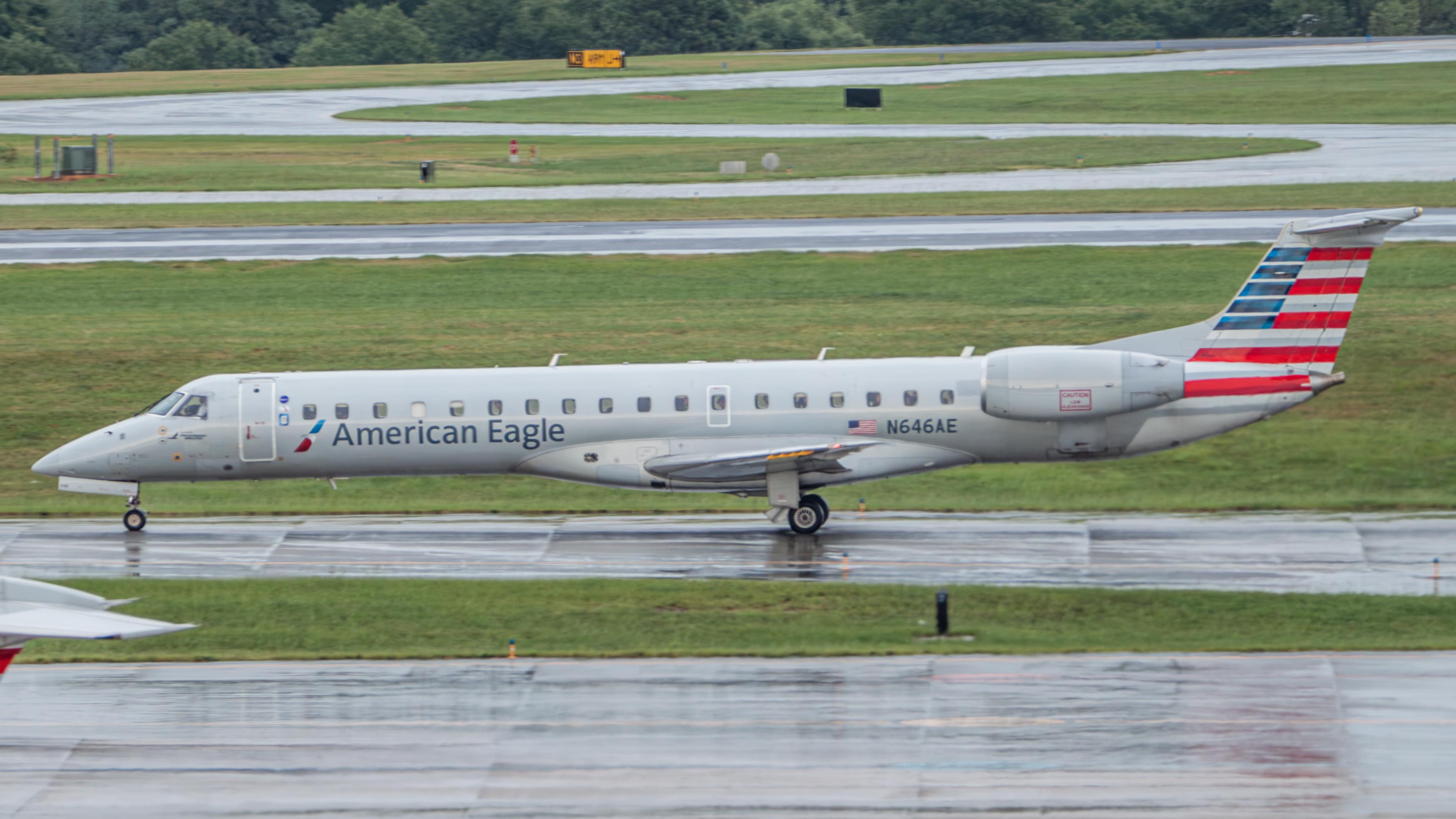
AviationLover50
@ KCLT
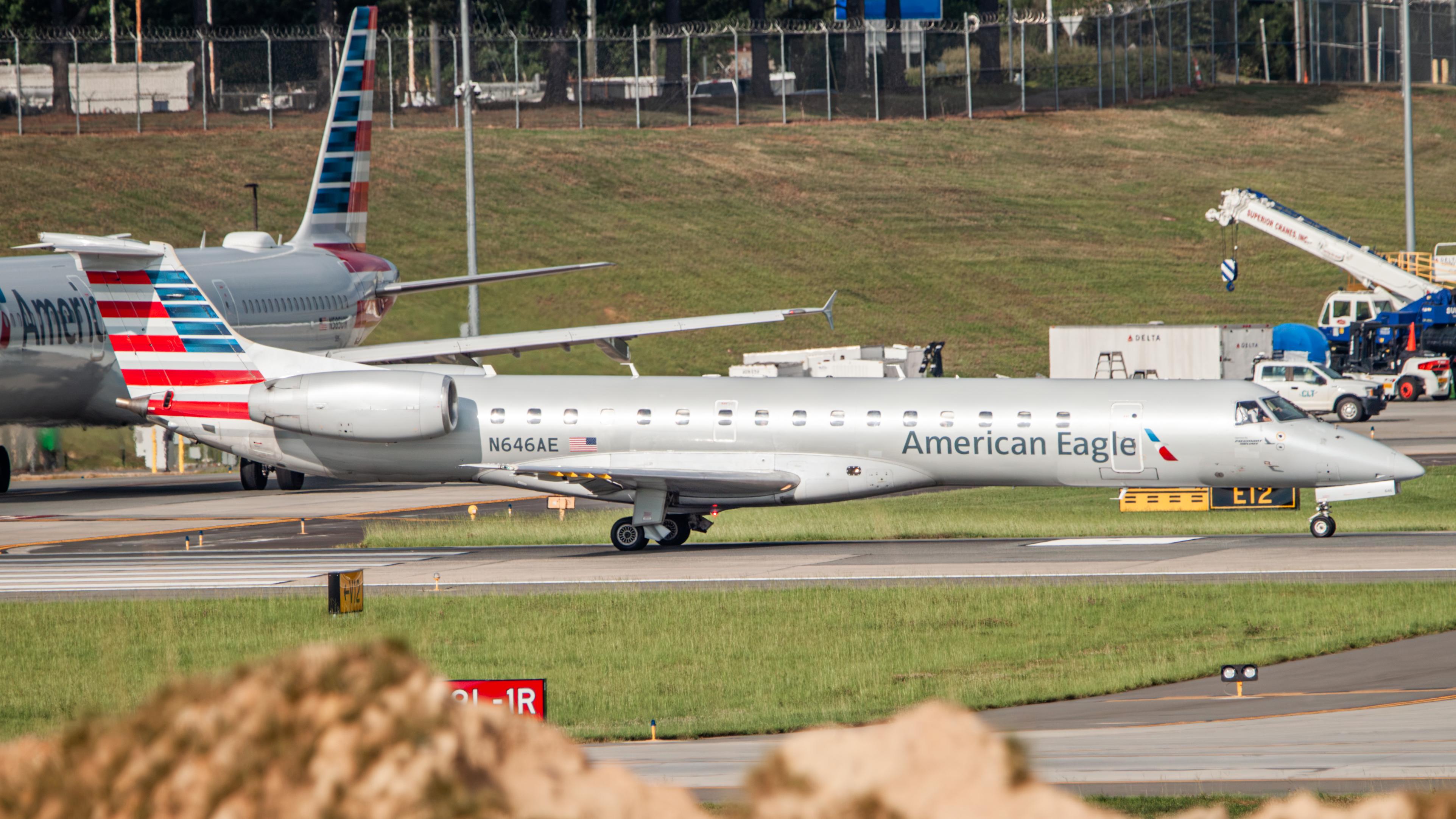
AviationLover50
@ KCLT

Florida Metal
@ KMIA
Arthur Tanyel
@ CLT
Recent Routes
NO LIVE DATA
Piedmont Airlines (1948-1989)
| Time | Callsign | FL | Speed | Heading | Route |
|---|---|---|---|---|---|
| 2026-10-23 03:26 UTC | PDT5907 / PI5907 | — | 12 kt | 56° | — |
| 2026-10-23 01:14 UTC | PDT5964 / PI5964 | FL7 | 132 kt | 357° | — |
| 2026-10-22 20:38 UTC | PDT6088 / PI6088 | FL21 | 137 kt | 357° | — |
| 2026-10-22 17:56 UTC | PDT5997 / PI5997 | FL17 | 132 kt | 356° | — |
| 2026-10-22 14:00 UTC | PDT6128 / PI6128 | FL16 | 126 kt | 356° | — |
| 2026-10-22 10:06 UTC | PDT5851 / PI5851 | FL14 | 125 kt | 356° | — |
| 2026-10-22 03:32 UTC | PDT5876 / PI5876 | FL41 | 169 kt | 350° | — |
| 2026-10-21 21:40 UTC | PDT5865 / PI5865 | — | 68 kt | 354° | — |
| 2026-10-21 18:12 UTC | PDT6004 / PI6004 | — | 21 kt | 37° | — |
| 2026-10-21 13:46 UTC | PDT5982 / PI5982 | FL8 | 135 kt | 356° | — |
| 2026-10-21 09:48 UTC | PDT5963 / PI5963 | — | 31 kt | 354° | — |
| 2026-10-21 00:52 UTC | PDT5869 / PI5869 | FL-1 | 129 kt | 348° | — |
| 2026-10-20 21:54 UTC | PDT6006 / PI6006 | FL6 | 131 kt | 356° | — |
| 2026-10-20 17:12 UTC | PDT5979 / PI5979 | — | 33 kt | 354° | — |
| 2026-10-20 12:48 UTC | PDT5927 / PI5927 | — | 66 kt | 357° | — |
| 2026-10-20 03:50 UTC | PDT5894 / PI5894 | FL9 | 125 kt | 28° | — |
| 2026-10-19 21:06 UTC | PDT5976 / PI5976 | FL5 | 138 kt | 355° | — |
| 2026-10-19 19:38 UTC | PDT5866 / PI5866 | FL15 | 153 kt | 225° |
ORH → PHL
ORH
→
PHL
Worcester Regional Airport → Philadelphia International Airport |
| 2026-10-19 17:26 UTC | PDT6009 / PI6009 | — | 27 kt | 340° | — |
| 2026-10-19 13:50 UTC | PDT5895 / PI5895 | FL-5 | 119 kt | 339° | — |
| 2026-10-18 23:36 UTC | PDT5812 / PI5812 | FL7 | 138 kt | 329° | — |
| 2026-10-18 20:48 UTC | PDT6059 / PI6059 | FL-6 | 130 kt | 339° | — |
| 2026-10-18 16:48 UTC | PDT5791 / PI5791 | — | 24 kt | 340° | — |
| 2026-10-18 14:42 UTC | PDT6124 / PI6124 | FL6 | 131 kt | 270° | — |
| 2026-10-17 18:16 UTC | PDT5853 / PI5853 | FL-3 | 112 kt | 339° | — |
| 2026-10-17 14:52 UTC | PDT5928 / PI5928 | FL39 | 121 kt | 339° | — |
| 2026-10-17 11:46 UTC | PDT5787 / PI5787 | FL8 | 118 kt | 356° | — |
| 2026-10-17 04:02 UTC | PDT5803 / PI5803 | FL35 | 220 kt | 235° | — |
| 2026-10-17 01:54 UTC | PDT5947 / PI5947 | FL8 | 118 kt | 176° | — |
| 2026-10-16 22:58 UTC | PDT6066 / PI6066 | FL9 | 143 kt | 176° | — |
| 2026-10-16 18:02 UTC | PDT5795 / PI5795 | FL8 | 146 kt | 176° | — |
| 2026-10-16 14:02 UTC | PDT5906 / PI5906 | FL7 | 136 kt | 176° | — |
| 2026-10-16 12:54 UTC | PDT5980 / PI5980 | FL40 | 273 kt | 6° | — |
| 2026-10-16 10:26 UTC | PDT5931 / PI5931 | — | 55 kt | 174° | — |
| 2026-10-16 03:38 UTC | PDT6073 / PI6073 | FL5 | 136 kt | 117° | — |
| 2026-10-16 00:36 UTC | PDT6035 / PI6035 | FL6 | 123 kt | 176° | — |
| 2026-10-15 19:30 UTC | PDT5987 / PI5987 | FL7 | 129 kt | 176° | — |
| 2026-10-15 15:38 UTC | PDT5996 / PI5996 | FL10 | 138 kt | 356° | — |
| 2026-10-15 11:28 UTC | PDT5915 / PI5915 | FL8 | 140 kt | 356° | — |
| 2026-10-15 02:50 UTC | PDT5879 / PI5879 | FL6 | 133 kt | 55° | — |
| 2026-10-14 23:10 UTC | PDT6067 / PI6067 | FL7 | 135 kt | 176° | — |
| 2026-10-14 11:32 UTC | PDT5785 / PI5785 | FL6 | 130 kt | 176° | — |
| 2026-10-14 01:28 UTC | PDT5971 / PI5971 | FL3 | 125 kt | 102° | — |
| 2026-10-13 22:42 UTC | PDT6074 / PI6074 | FL8 | 133 kt | 356° | — |
| 2026-10-13 17:50 UTC | PDT6050 / PI6050 | FL10 | 139 kt | 357° | — |
| 2026-10-13 13:08 UTC | PDT5960 / PI5960 | FL7 | 131 kt | 357° | — |
| 2026-10-13 01:50 UTC | PDT5875 / PI5875 | FL9 | 129 kt | 197° | — |
| 2026-10-12 23:26 UTC | PDT6058 / PI6058 | FL8 | 138 kt | 355° | — |
| 2026-10-12 21:56 UTC | PDT5829 / PI5829 | FL9 | 139 kt | 32° | — |
| 2026-10-12 20:18 UTC | PDT6084 / PI6084 | FL8 | 135 kt | 355° | — |
| 2026-10-12 15:58 UTC | PDT6119 / PI6119 | FL8 | 140 kt | 357° | — |
| 2026-10-12 13:56 UTC | PDT5925 / PI5925 | FL9 | 143 kt | 212° | — |
| 2026-10-12 03:14 UTC | PDT5838 / PI5838 | — | 8 kt | 281° | — |
| 2026-10-11 21:44 UTC | PDT6100 / PI6100 | — | 19 kt | 340° | — |
| 2026-10-11 19:36 UTC | PDT5848 / PI5848 | FL6 | 132 kt | 117° | — |
| 2026-10-11 16:34 UTC | PDT5898 / PI5898 | — | 48 kt | 177° | — |
| 2026-10-11 13:30 UTC | PDT5905 / PI5905 | — | 10 kt | 183° | — |
| 2026-10-11 05:38 UTC | PDT6044 / PI6044 | FL8 | 134 kt | 175° | — |
| 2026-10-11 02:24 UTC | PDT5822 / PI5822 | FL47 | 228 kt | 139° | — |
| 2026-10-10 23:32 UTC | PDT5946 / PI5946 | FL7 | 153 kt | 357° | — |
| 2026-10-10 16:28 UTC | PDT6069 / PI6069 | FL7 | 143 kt | 356° | — |
| 2026-10-10 14:46 UTC | PDT5911 / PI5911 | FL16 | 124 kt | 180° | — |
| 2026-10-10 09:44 UTC | PDT5859 / PI5859 | FL7 | 144 kt | 357° | — |
| 2026-10-10 03:58 UTC | PDT5871 / PI5871 | FL17 | 110 kt | 104° | — |
| 2026-10-10 00:36 UTC | PDT6026 / PI6026 | — | 34 kt | 354° | — |
| 2026-10-09 18:40 UTC | PDT5966 / PI5966 | FL9 | 129 kt | 356° | — |
| 2026-10-09 14:56 UTC | PDT6061 / PI6061 | FL6 | 126 kt | 356° | — |
| 2026-10-09 11:44 UTC | PDT5916 / PI5916 | FL6 | 128 kt | 356° | — |
| 2026-10-09 02:26 UTC | PDT5881 / PI5881 | FL64 | 257 kt | 284° | — |
| 2026-10-08 18:58 UTC | PDT5940 / PI5940 | FL8 | 156 kt | 356° | — |
| 2026-10-08 00:42 UTC | PDT5991 / PI5991 | FL8 | 136 kt | 356° | — |
| 2026-10-07 19:32 UTC | PDT6089 / PI6089 | — | 15 kt | 143° | — |
| 2026-10-07 15:56 UTC | PDT5990 / PI5990 | FL10 | 138 kt | 356° | — |
| 2026-10-07 14:04 UTC | PDT5897 / PI5897 | FL24 | 164 kt | 9° |
ROA → CLT
ROA
→
CLT
Roanoke/blacksburg Regional (woodrum Fld) Airport → Charlotte/douglas International Airport |
| 2026-10-07 00:26 UTC | PDT5833 / PI5833 | FL10 | 109 kt | 230° |
PHL → ROA
PHL
→
ROA
Philadelphia International Airport → Roanoke/blacksburg Regional (woodrum Fld) Airport |
| 2026-10-06 22:42 UTC | PDT6077 / PI6077 | — | 63 kt | 256° | — |
| 2026-10-06 14:22 UTC | PDT6127 / PI6127 | FL42 | 201 kt | 336° | — |
| 2026-10-06 12:14 UTC | PDT6022 / PI6022 | — | 10 kt | 287° | — |
| 2026-10-06 02:00 UTC | PDT6020 / PI6020 | FL55 | 266 kt | 65° | — |
| 2026-10-06 00:02 UTC | PDT6000 / PI6000 | — | 12 kt | 259° | — |
| 2026-10-05 22:22 UTC | PDT6120 / PI6120 | FL11 | 132 kt | 298° | — |
| 2026-10-05 09:50 UTC | PDT5926 / PI5926 | FL7 | 132 kt | 356° | — |
| 2026-10-05 03:22 UTC | PDT5832 / PI5832 | FL118 | 313 kt | 335° | — |
| 2026-10-05 00:42 UTC | PDT6002 / PI6002 | FL8 | 137 kt | 357° | — |
| 2026-10-04 20:12 UTC | PDT6031 / PI6031 | FL9 | 132 kt | 356° | — |
| 2026-10-04 11:12 UTC | PDT6060 / PI6060 | FL-3 | 131 kt | 339° | — |
| 2026-10-04 00:54 UTC | PDT5802 / PI5802 | FL24 | 123 kt | 46° | — |
| 2026-10-03 22:42 UTC | PDT5836 / PI5836 | FL-3 | 116 kt | 339° | — |
| 2026-10-03 18:06 UTC | PDT6126 / PI6126 | — | 26 kt | 340° |
PHL → ROC
PHL
→
ROC
Philadelphia International Airport → Frederick Douglass/greater Rochester International Airport |
| 2026-10-03 12:56 UTC | PDT5844 / PI5844 | — | 12 kt | 340° | — |
| 2026-10-03 03:04 UTC | PDT5877 / PI5877 | FL5 | 125 kt | 269° | — |
| 2026-10-03 00:08 UTC | PDT5923 / PI5923 | — | 41 kt | 256° | — |
| 2026-10-02 18:08 UTC | PDT5948 / PI5948 | FL12 | 135 kt | 298° | — |
| 2026-10-02 15:58 UTC | PDT6018 / PI6018 | — | 30 kt | 177° | — |
| 2026-10-01 23:46 UTC | PDT5985 / PI5985 | FL14 | 134 kt | 176° | — |
| 2026-10-01 17:10 UTC | PDT5864 / PI5864 | FL17 | 146 kt | 357° | — |
| 2026-10-01 15:12 UTC | PDT5943 / PI5943 | FL25 | 141 kt | 160° | — |
| 2026-10-01 02:32 UTC | PDT6014 / PI6014 | FL34 | 256 kt | 110° | — |
| 2026-10-01 00:04 UTC | PDT5981 / PI5981 | FL14 | 130 kt | 357° | — |
| 2026-09-30 20:18 UTC | PDT5994 / PI5994 | FL17 | 160 kt | 356° | — |
| 2026-09-30 17:32 UTC | PDT5908 / PI5908 | FL13 | 138 kt | 329° |
PHL → ROA
PHL
→
ROA
Philadelphia International Airport → Roanoke/blacksburg Regional (woodrum Fld) Airport |
| 2026-09-30 15:40 UTC | PDT6032 / PI6032 | FL-2 | 136 kt | 339° | — |
| 2026-09-30 13:38 UTC | PDT8820 / PI8820 | FL3 | 140 kt | 43° | — |
| 2026-09-29 18:40 UTC | PDT5900 / PI5900 | FL13 | 145 kt | 355° |
CLT → K6L4
CLT
→
K6L4
Charlotte/douglas International Airport → Logan County Airport |
| 2026-09-29 10:58 UTC | PDT5917 / PI5917 | FL10 | 145 kt | 356° | — |
| 2026-09-29 04:24 UTC | PDT5903 / PI5903 | FL3 | 130 kt | 13° | — |
| 2026-09-28 13:10 UTC | PDT5850 / PI5850 | FL9 | 133 kt | 356° | — |
| 2026-09-27 22:52 UTC | PDT5973 / PI5973 | FL11 | 131 kt | 356° | — |
| 2026-09-27 19:02 UTC | PDT6034 / PI6034 | FL11 | 140 kt | 356° |
PHL → ORH
PHL
→
ORH
Philadelphia International Airport → Worcester Regional Airport |
| 2026-09-27 14:12 UTC | PDT5824 / PI5824 | FL12 | 142 kt | 356° | — |
| 2026-09-27 01:42 UTC | PDT5882 / PI5882 | FL24 | 233 kt | 166° | — |
| 2026-09-26 18:30 UTC | PDT6076 / PI6076 | — | 6 kt | 276° | — |
| 2026-09-26 00:58 UTC | PDT5796 / PI5796 | FL6 | 129 kt | 358° | — |
| 2026-09-25 22:48 UTC | PDT6055 / PI6055 | — | 8 kt | 158° | — |
| 2026-09-25 18:08 UTC | PDT5800 / PI5800 | — | 15 kt | 340° | — |
| 2026-09-25 11:10 UTC | PDT6115 / PI6115 | — | 15 kt | 338° | — |
| 2026-09-25 01:14 UTC | PDT5798 / PI5798 | FL-1 | 128 kt | 44° |
PHL → BDL
PHL
→
BDL
Philadelphia International Airport → Bradley International Airport |
| 2026-09-24 21:50 UTC | PDT5974 / PI5974 | — | 8 kt | 160° | — |
| 2026-09-24 17:24 UTC | PDT5878 / PI5878 | — | 15 kt | 6° | — |
| 2026-09-24 13:02 UTC | PDT5789 / PI5789 | FL-4 | 125 kt | 339° |
ROC → PHL
ROC
→
PHL
Frederick Douglass/greater Rochester International Airport → Philadelphia International Airport |
| 2026-09-24 00:04 UTC | PDT5811 / PI5811 | — | 26 kt | 315° | — |
| 2026-09-23 21:08 UTC | PDT6047 / PI6047 | — | 10 kt | 287° |
PHL → CLE
PHL
→
CLE
Philadelphia International Airport → Cleveland-hopkins International Airport |
| 2026-09-23 16:10 UTC | PDT5827 / PI5827 | — | 23 kt | 338° | — |
Live location data from OpenSky Network
Airframe Info
| Manufacturer | Embraer |
| Model | ERJ-145LR (EMB-145LR) Search all Embraer ERJ-145LR (EMB-145LR) |
| Year built | 2000 |
| Construction Number (C/N) | 145213 |
| Aircraft Type | Fixed wing multi engine |
| Number of Seats | 55 |
| Number of Engines | 2 |
| Engine Type | Turbofan |
| Engine Manufacturer and Model | Allison AE 3007A |
Aircraft
| Registration Number | N646AE |
| Mode S (ICAO24) Code | a87b8a |
| Certification Class | Standard |
| Certification Issued | 2011-09-12 |
| Air Worthiness Test | 2000-01-22 |
| Last Action Taken | 2023-03-17 |
| Current Status | Valid |
Owner
| Registration Type | Corporation |
| Owner | AMERICAN AIRLINES INC |
| Address |
Md 8b369 Fort Worth, TX 76155 United States |
| Region | Southwestern |