N690CA — 2004 Bombardier CRJ-700 (CL-600-2C10) Regional Jet Data
1
aircraft record found
N690CA
2004 Bombardier CRJ-700 (CL-600-2C10) Regional Jet, c/n 10182
N690CA is a 2004 Bombardier CRJ-700 (CL-600-2C10) Regional Jet (serial number 10182). It is configured with 2 engines and 22 seats. Registration status is listed as Valid, with ownership recorded under DELTA AIR LINES INC in Atlanta, GA, United States. The profile includes 16 photos documenting this aircraft.
Latest photos of N690CA

Florida Metal
@ KDTW
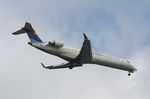
Florida Metal
@ KTPA

Florida Metal
@ DTW
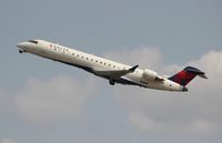
Florida Metal
@ DTW
Recent Routes
IN FLIGHT
EDV5530
| Time | Callsign | FL | Speed | Heading | Route |
|---|---|---|---|---|---|
| 2026-11-20 03:40 UTC | EDV5530 | FL310 | 463 kt | 128° | — |
| 2026-11-20 00:56 UTC | EDV4714 | — | 4 kt | 222° |
MSP → MDW
MSP
→
MDW
Minneapolis-st Paul Intl/wold-chamberlain Airport → Chicago Midway International Airport |
| 2026-11-19 19:48 UTC | EDV4901 | — | 0 kt | 217° |
MSP → MDW
MSP
→
MDW
Minneapolis-st Paul Intl/wold-chamberlain Airport → Chicago Midway International Airport |
| 2026-11-19 13:44 UTC | EDV5402 | — | 0 kt | 208° | — |
| 2026-11-19 03:04 UTC | EDV5253 | FL8 | 134 kt | 133° | — |
| 2026-11-18 13:22 UTC | EDV5248 | — | 0 kt | 127° | — |
| 2026-11-18 04:54 UTC | EDV5290 | — | 132 kt | 90° |
MSP → CID
MSP
→
CID
Minneapolis-st Paul Intl/wold-chamberlain Airport → The Eastern Iowa Airport |
| 2026-11-17 23:20 UTC | EDV4821 | — | 1 kt | 225° |
STL → MSP
STL
→
MSP
St Louis Lambert International Airport → Minneapolis-st Paul Intl/wold-chamberlain Airport |
| 2026-11-17 21:08 UTC | EDV5165 | — | 0 kt | 270° |
MSP → STL
MSP
→
STL
Minneapolis-st Paul Intl/wold-chamberlain Airport → St Louis Lambert International Airport |
| 2026-11-17 18:56 UTC | EDV5469 | — | 0 kt | 194° |
MDW → MSP
MDW
→
MSP
Chicago Midway International Airport → Minneapolis-st Paul Intl/wold-chamberlain Airport |
| 2026-11-17 16:58 UTC | EDV4684 | FL2 | 137 kt | 133° |
DTW → MDW
DTW
→
MDW
Detroit Metro Wayne County Airport → Chicago Midway International Airport |
| 2026-11-17 15:00 UTC | EDV4639 | FL2 | 135 kt | 208° | — |
| 2026-11-17 01:20 UTC | EDV5109 | FL3 | 111 kt | 208° | — |
| 2026-11-16 21:16 UTC | EDV4896 | — | 17 kt | 118° | — |
| 2026-11-16 17:00 UTC | EDV5453 | FL324 | 129 kt | 209° |
SDF → DTW
SDF
→
DTW
Louisville Muhammad Ali International Airport → Detroit Metro Wayne County Airport |
| 2026-11-16 14:58 UTC | EDV5441 | FL1 | 134 kt | 345° | — |
| 2026-11-16 13:00 UTC | EDV5279 | FL3 | 137 kt | 208° | — |
| 2026-11-16 05:12 UTC | EDV5448 | FL9 | 121 kt | 327° | — |
| 2026-11-16 02:40 UTC | EDV5214 | FL3 | 136 kt | 29° | — |
| 2026-11-16 00:58 UTC | EDV5245 | FL6 | 140 kt | 2° | — |
| 2026-11-15 17:10 UTC | EDV5196 | FL4 | 132 kt | 29° | — |
| 2026-11-15 00:50 UTC | EDV5138 | — | 124 kt | 45° | — |
| 2026-11-14 13:50 UTC | EDV4652 | FL7 | 137 kt | 29° | — |
| 2026-11-13 19:50 UTC | EDV5117 | FL15 | 134 kt | 17° | — |
| 2026-11-13 12:30 UTC | EDV5088 | FL8 | 128 kt | 29° | — |
| 2026-11-13 03:28 UTC | EDV5407 | FL32 | 168 kt | 225° | — |
| 2026-11-13 01:00 UTC | EDV5345 | FL9 | 126 kt | 29° | — |
| 2026-11-12 19:50 UTC | EDV5331 | FL10 | 126 kt | 28° | — |
| 2026-11-12 16:36 UTC | EDV5073 | FL10 | 134 kt | 28° |
YYZ → DTW
YYZ
→
DTW
Lester B Pearson International Airport → Detroit Metro Wayne County Airport |
| 2026-11-12 14:44 UTC | EDV5140 | FL7 | 0 kt | 113° |
DTW → YYZ
DTW
→
YYZ
Detroit Metro Wayne County Airport → Lester B Pearson International Airport |
| 2026-11-12 12:22 UTC | EDV4885 | FL11 | 132 kt | 29° | — |
| 2026-11-12 04:32 UTC | EDV4880 | FL10 | 138 kt | 351° | — |
| 2026-11-11 23:22 UTC | EDV4709 | FL10 | 145 kt | 209° | — |
| 2026-11-11 20:56 UTC | EDV4646 | FL13 | 146 kt | 296° | — |
| 2026-11-11 16:22 UTC | EDV4711 | FL9 | 137 kt | 209° |
MDW → DTW
MDW
→
DTW
Chicago Midway International Airport → Detroit Metro Wayne County Airport |
| 2026-11-11 14:50 UTC | EDV4712 | FL8 | 138 kt | 314° |
MSP → MDW
MSP
→
MDW
Minneapolis-st Paul Intl/wold-chamberlain Airport → Chicago Midway International Airport |
| 2026-11-10 13:18 UTC | EDV5056 | FL8 | 121 kt | 208° |
YUL → DTW
YUL
→
DTW
Montreal / Pierre Elliott Trudeau International Airport → Detroit Metro Wayne County Airport |
| 2026-11-10 04:18 UTC | EDV5136 | — | 15 kt | 141° | — |
| 2026-11-10 01:28 UTC | EDV5090 | FL7 | 128 kt | 208° | — |
| 2026-11-09 20:24 UTC | EDV4688 | — | 17 kt | 203° | — |
| 2026-11-09 01:32 UTC | EDV4677 | FL8 | 135 kt | 209° | — |
| 2026-11-08 16:40 UTC | EDV5101 | FL9 | 121 kt | 209° | — |
| 2026-11-08 12:28 UTC | EDV5504 | FL8 | 125 kt | 209° |
MSP → YYZ
MSP
→
YYZ
Minneapolis-st Paul Intl/wold-chamberlain Airport → Lester B Pearson International Airport |
| 2026-11-08 03:38 UTC | EDV5112 | FL10 | 113 kt | 299° | — |
| 2026-11-08 00:24 UTC | EDV5037 | FL7 | 133 kt | 209° | — |
| 2026-11-07 19:32 UTC | EDV5533 | FL7 | 137 kt | 209° | — |
| 2026-11-07 14:50 UTC | EDV4897 | FL6 | 127 kt | 28° | — |
| 2026-11-07 03:08 UTC | EDV4898 | FL6 | 132 kt | 44° | — |
| 2026-11-07 01:16 UTC | EDV5446 | FL7 | 141 kt | 29° | — |
| 2026-11-06 15:58 UTC | EDV5494 | FL8 | 137 kt | 209° | — |
| 2026-11-06 05:56 UTC | EDV5082 | FL7 | 138 kt | 130° | — |
| 2026-11-05 18:04 UTC | EDV5256 | FL10 | 131 kt | 208° |
YYZ → DTW
YYZ
→
DTW
Lester B Pearson International Airport → Detroit Metro Wayne County Airport |
| 2026-11-05 16:16 UTC | EDV5251 | — | 0 kt | 87° |
DTW → YYZ
DTW
→
YYZ
Detroit Metro Wayne County Airport → Lester B Pearson International Airport |
| 2026-11-03 17:18 UTC | EDV5205 | FL7 | 127 kt | 208° |
MSN → DTW
MSN
→
DTW
Dane County Rgnl/truax Fld Airport → Detroit Metro Wayne County Airport |
| 2026-11-02 19:46 UTC | EDV5011 | — | 6 kt | 298° | — |
| 2026-11-02 13:42 UTC | EDV5027 | — | 0 kt | 222° | — |
| 2026-11-02 03:34 UTC | EDV5043 | FL73 | 270 kt | 140° |
ABE → ATL
ABE
→
ATL
Lehigh Valley International Airport → Hartsfield/jackson Atlanta International Airport |
| 2026-11-01 22:58 UTC | EDV4693 | — | 6 kt | 267° | — |
| 2026-11-01 19:04 UTC | EDV5435 | FL0 | 136 kt | 329° | — |
| 2026-11-01 15:22 UTC | EDV5553 | — | 0 kt | 278° | — |
| 2026-10-30 22:50 UTC | EDV5224 | FL4 | 129 kt | 28° | — |
| 2026-10-30 18:52 UTC | EDV5078 | FL4 | 140 kt | 29° | — |
| 2026-10-30 00:34 UTC | EDV5053 | FL7 | 136 kt | 209° | — |
| 2026-10-29 22:44 UTC | EDV4635 | FL8 | 130 kt | 226° | — |
| 2026-10-29 20:44 UTC | EDV4962 | FL8 | 144 kt | 209° | — |
| 2026-10-29 15:06 UTC | EDV5240 | FL7 | 131 kt | 208° | — |
| 2026-10-29 11:00 UTC | EDV5319 | FL6 | 129 kt | 208° | — |
| 2026-10-29 03:52 UTC | EDV5369 | FL12 | 134 kt | 273° | — |
| 2026-10-29 00:52 UTC | EDV5498 | FL6 | 128 kt | 209° | — |
| 2026-10-28 16:18 UTC | EDV5272 | FL5 | 132 kt | 209° | — |
| 2026-10-28 12:36 UTC | EDV5414 | FL5 | 133 kt | 209° |
DSM → DTW
DSM
→
DTW
Des Moines International Airport → Detroit Metro Wayne County Airport |
| 2026-10-28 03:14 UTC | EDV5087 | FL8 | 132 kt | 132° |
DTW → DSM
DTW
→
DSM
Detroit Metro Wayne County Airport → Des Moines International Airport |
| 2026-10-28 00:10 UTC | EDV4697 | FL5 | 135 kt | 209° | — |
| 2026-10-27 22:06 UTC | EDV5335 | FL12 | 145 kt | 45° | — |
| 2026-10-26 21:46 UTC | EDV5490 | — | 5 kt | 233° |
MSP → DSM
MSP
→
DSM
Minneapolis-st Paul Intl/wold-chamberlain Airport → Des Moines International Airport |
| 2026-10-26 16:50 UTC | EDV5135 | — | 0 kt | 211° | — |
| 2026-10-25 23:08 UTC | EDV5169 | — | 0 kt | 203° |
GRB → MSP
GRB
→
MSP
Green Bay/austin Straubel International Airport → Minneapolis-st Paul Intl/wold-chamberlain Airport |
| 2026-10-25 17:36 UTC | EDV5280 | — | 0 kt | 217° | — |
| 2026-10-25 12:06 UTC | EDV5464 | — | 0 kt | 208° |
GRB → MSP
GRB
→
MSP
Green Bay/austin Straubel International Airport → Minneapolis-st Paul Intl/wold-chamberlain Airport |
| 2026-10-25 02:28 UTC | EDV4651 | — | 0 kt | 17° |
MSP → GRB
MSP
→
GRB
Minneapolis-st Paul Intl/wold-chamberlain Airport → Green Bay/austin Straubel International Airport |
| 2026-10-24 01:10 UTC | EDV5063 | — | 7 kt | 233° | — |
| 2026-10-22 18:44 UTC | EDV5390 | FL5 | 136 kt | 29° | — |
Live location data from OpenSky Network
Airframe Info
| Manufacturer | Bombardier |
| Model | CRJ-700 (CL-600-2C10) Regional Jet Search all Bombardier CRJ-700 (CL-600-2C10) Regional Jet |
| Year built | 2004 |
| Construction Number (C/N) | 10182 |
| Aircraft Type | Fixed wing multi engine |
| Number of Seats | 22 |
| Number of Engines | 2 |
| Engine Type | Turbofan |
| Engine Manufacturer and Model | General Electric CF34-8C1 |
Aircraft
| Registration Number | N690CA |
| Mode S (ICAO24) Code | a92ae9 |
| Certification Issued | 2012-11-07 |
| Last Action Taken | 2023-06-23 |
| Current Status | Valid |
Owner
| Registration Type | Corporation |
| Owner | DELTA AIR LINES INC |
| Address |
Dept 595 Aircraft Registrations Atlanta, GA 303543743 United States |
| Region | Southern |