N718PS — 2004 Bombardier CRJ-701 (CL-600-2C10) Regional Jet Data
1
aircraft record found
N718PS
2004 Bombardier CRJ-701 (CL-600-2C10) Regional Jet, c/n 10175
N718PS is a 2004 Bombardier CRJ-701 (CL-600-2C10) Regional Jet (serial number 10175). It is configured with 2 engines and 22 seats. Registration status is listed as Valid, with ownership recorded under AMERICAN AIRLINES INC in Fort Worth, TX, United States. The profile includes 8 photos documenting this aircraft.
Latest photos of N718PS
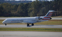
Ryan Hunt
@ RDU

Ronald Barker
@ KCLT

Ronald Barker
@ KCLT
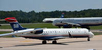
Ronald Barker
@ KCLT
Recent Routes
| Time | Callsign | FL | Speed | Heading | Route |
|---|---|---|---|---|---|
| 2026-10-27 23:36 UTC | JIA5501 | FL165 | 376 kt | 236° | — |
| 2026-10-27 20:00 UTC | JIA5324 | — | 10 kt | 323° |
YYZ → DCA
YYZ
→
DCA
Lester B Pearson International Airport → Ronald Reagan Washington Ntl Airport |
| 2026-10-27 15:08 UTC | JIA5072 | FL-4 | 125 kt | 355° |
DCA → IND
DCA
→
IND
Ronald Reagan Washington Ntl Airport → Indianapolis International Airport |
| 2026-10-27 02:14 UTC | JIA5452 | — | 10 kt | 323° |
DCA → RDU
DCA
→
RDU
Ronald Reagan Washington Ntl Airport → Raleigh-durham International Airport |
| 2026-10-26 21:52 UTC | JIA5296 | — | 12 kt | 335° |
DCA → DSM
DCA
→
DSM
Ronald Reagan Washington Ntl Airport → Des Moines International Airport |
| 2026-10-25 19:44 UTC | JIA5647 | — | 15 kt | 323° | — |
| 2026-10-25 16:26 UTC | JIA5373 | FL6 | 131 kt | 182° |
DCA → MSN
DCA
→
MSN
Ronald Reagan Washington Ntl Airport → Dane County Rgnl/truax Fld Airport |
| 2026-10-25 13:14 UTC | JIA5485 | FL-6 | 115 kt | 356° |
MSP → DCA
MSP
→
DCA
Minneapolis-st Paul Intl/wold-chamberlain Airport → Ronald Reagan Washington Ntl Airport |
| 2026-10-24 20:16 UTC | JIA5183 | — | 6 kt | 127° |
MSP → DCA
MSP
→
DCA
Minneapolis-st Paul Intl/wold-chamberlain Airport → Ronald Reagan Washington Ntl Airport |
| 2026-10-24 16:36 UTC | JIA5668 | — | 0 kt | 321° |
YYZ → DCA
YYZ
→
DCA
Lester B Pearson International Airport → Ronald Reagan Washington Ntl Airport |
| 2026-10-24 14:36 UTC | JIA5522 | FL0 | 0 kt | 110° |
PHL → YYZ
PHL
→
YYZ
Philadelphia International Airport → Lester B Pearson International Airport |
| 2026-10-24 11:16 UTC | JIA5414 | — | 3 kt | 304° | — |
| 2026-10-24 02:12 UTC | JIA5269 | FL4 | 137 kt | 209° | — |
| 2026-10-23 23:16 UTC | JIA5404 | — | 3 kt | 259° | — |
| 2026-10-23 19:18 UTC | JIA5626 | — | 76 kt | 323° |
DCA → RDU
DCA
→
RDU
Ronald Reagan Washington Ntl Airport → Raleigh-durham International Airport |
| 2026-10-23 15:18 UTC | JIA5108 | — | 10 kt | 323° | — |
| 2026-10-23 10:26 UTC | JIA5062 | — | 10 kt | 321° |
CAK → DCA
CAK
→
DCA
Akron-canton Regional Airport → Ronald Reagan Washington Ntl Airport |
| 2026-10-23 07:14 UTC | MTXN718 | — | 0 kt | 149° | — |
| 2026-10-23 02:42 UTC | JIA5184 | — | 0 kt | 149° | — |
| 2026-10-22 23:30 UTC | JIA5113 | FL7 | 132 kt | 357° | — |
| 2026-10-22 21:10 UTC | JIA5321 | FL9 | 141 kt | 56° | — |
| 2026-10-22 18:38 UTC | JIA5573 | FL17 | 130 kt | 356° | — |
| 2026-10-22 14:32 UTC | JIA5572 | FL14 | 126 kt | 355° | — |
| 2026-10-22 12:52 UTC | JIA5475 | FL9 | 129 kt | 41° | — |
| 2026-10-22 10:10 UTC | JIA5199 | FL13 | 121 kt | 356° | — |
| 2026-10-22 02:44 UTC | JIA5655 | FL7 | 133 kt | 275° | — |
| 2026-10-21 23:52 UTC | JIA5549 | FL7 | 133 kt | 356° | — |
| 2026-10-21 22:08 UTC | JIA5293 | FL8 | 138 kt | 1° | — |
| 2026-10-21 19:20 UTC | JIA5180 | — | 78 kt | 357° | — |
| 2026-10-21 13:34 UTC | JIA5403 | FL10 | 120 kt | 356° | — |
| 2026-10-21 03:16 UTC | JIA5289 | FL2 | 121 kt | 330° | — |
| 2026-10-20 23:50 UTC | JIA5128 | — | 17 kt | 323° | — |
| 2026-10-20 20:24 UTC | JIA5497 | FL17 | 139 kt | 90° | — |
| 2026-10-20 11:48 UTC | JIA5088 | — | 6 kt | 284° | — |
| 2026-10-20 01:22 UTC | JIA5550 | FL0 | 128 kt | 38° | — |
| 2026-10-19 23:16 UTC | JIA5134 | — | 4 kt | 293° |
BGR → PHL
BGR
→
PHL
Bangor International Airport → Philadelphia International Airport |
| 2026-10-19 18:02 UTC | JIA5032 | — | 13 kt | 39° | — |
| 2026-10-19 13:06 UTC | JIA5218 | — | 8 kt | 304° | — |
| 2026-10-19 02:48 UTC | JIA5357 | FL15 | 124 kt | 55° | — |
| 2026-10-19 00:02 UTC | JIA5274 | — | 0 kt | 248° |
DCA → MSY
DCA
→
MSY
Ronald Reagan Washington Ntl Airport → Louis Armstrong New Orleans International Airport |
| 2026-10-18 21:06 UTC | JIA5224 | FL9 | 136 kt | 44° | — |
| 2026-10-18 18:52 UTC | JIA5535 | — | 13 kt | 264° |
DCA → CLE
DCA
→
CLE
Ronald Reagan Washington Ntl Airport → Cleveland-hopkins International Airport |
| 2026-10-18 14:26 UTC | JIA5374 | — | 0 kt | 321° |
MSN → DCA
MSN
→
DCA
Dane County Rgnl/truax Fld Airport → Ronald Reagan Washington Ntl Airport |
| 2026-10-17 22:28 UTC | JIA5221 | FL6 | 126 kt | 182° | — |
| 2026-10-17 19:12 UTC | JIA5599 | — | 10 kt | 349° | — |
| 2026-10-17 07:42 UTC | JIA5496 | — | 1 kt | 129° |
DCA → MSP
DCA
→
MSP
Ronald Reagan Washington Ntl Airport → Minneapolis-st Paul Intl/wold-chamberlain Airport |
| 2026-10-17 03:58 UTC | JIA5500 | — | 10 kt | 329° | — |
| 2026-10-16 16:32 UTC | JIA529S | — | 12 kt | 326° | — |
| 2026-10-14 23:54 UTC | JIA5172 | — | 15 kt | 323° | — |
| 2026-10-13 22:28 UTC | JIA5457 | — | 8 kt | 321° |
ROC → DCA
ROC
→
DCA
Frederick Douglass/greater Rochester International Airport → Ronald Reagan Washington Ntl Airport |
| 2026-10-13 17:56 UTC | JIA5213 | — | 10 kt | 326° | — |
| 2026-10-13 15:18 UTC | JIA5053 | FL36 | 136 kt | 339° | — |
| 2026-10-13 13:26 UTC | JIA5359 | — | 8 kt | 290° | — |
| 2026-10-13 03:42 UTC | JIA5025 | FL97 | 340 kt | 208° | — |
| 2026-10-13 00:58 UTC | JIA5458 | — | 7 kt | 262° | — |
| 2026-10-12 11:54 UTC | JIA5362 | — | 11 kt | 20° | — |
| 2026-10-12 06:28 UTC | JIA5317 | FL5 | 129 kt | 322° | — |
| 2026-10-12 03:20 UTC | JIA5189 | — | 0 kt | 304° | — |
| 2026-10-12 01:02 UTC | JIA5636 | FL3 | 134 kt | 141° | — |
| 2026-10-11 22:18 UTC | JIA5663 | — | 1 kt | 301° |
PHL → RDU
PHL
→
RDU
Philadelphia International Airport → Raleigh-durham International Airport |
| 2026-10-11 00:58 UTC | JIA5532 | — | 9 kt | 169° | — |
| 2026-10-10 19:04 UTC | JIA5298 | — | 20 kt | 340° | — |
| 2026-10-10 12:42 UTC | JIA9954 | FL-1 | 118 kt | 37° | — |
| 2026-10-09 22:52 UTC | JIA5021 | FL7 | 130 kt | 356° | — |
| 2026-10-09 17:46 UTC | JIA5604 | FL7 | 140 kt | 356° | — |
| 2026-10-09 15:56 UTC | JIA5482 | FL58 | 258 kt | 131° | — |
| 2026-10-09 13:32 UTC | JIA5417 | FL6 | 130 kt | 356° | — |
| 2026-10-05 00:08 UTC | JIA5305 | — | 0 kt | 149° |
DCA → CAK
DCA
→
CAK
Ronald Reagan Washington Ntl Airport → Akron-canton Regional Airport |
| 2026-10-04 19:44 UTC | JIA5039 | — | 18 kt | 323° | — |
| 2026-10-03 23:10 UTC | JIA5284 | FL9 | 128 kt | 55° | — |
| 2026-10-03 15:10 UTC | JIA5678 | — | 14 kt | 340° | — |
| 2026-10-03 13:16 UTC | JIA528T | FL2 | 121 kt | 330° | — |
| 2026-10-02 11:40 UTC | JIA5160 | — | 2 kt | 326° | — |
| 2026-10-02 03:58 UTC | JIA5283 | FL6 | 127 kt | 222° | — |
| 2026-10-02 00:56 UTC | JIA5139 | — | 13 kt | 323° |
DCA → PNS
DCA
→
PNS
Ronald Reagan Washington Ntl Airport → Pensacola International Airport |
| 2026-10-01 17:52 UTC | JIA5449 | — | 2 kt | 307° | — |
| 2026-09-29 16:50 UTC | JIA5027 | — | 5 kt | 250° | — |
| 2026-09-29 12:46 UTC | JIA5146 | — | 14 kt | 349° | — |
| 2026-09-29 01:54 UTC | JIA5384 | FL5 | 128 kt | 91° | — |
| 2026-09-28 10:26 UTC | JIA5351 | — | 0 kt | 214° |
ROC → DCA
ROC
→
DCA
Frederick Douglass/greater Rochester International Airport → Ronald Reagan Washington Ntl Airport |
| 2026-09-28 04:10 UTC | JIA5344 | — | 0 kt | 352° |
DCA → ROC
DCA
→
ROC
Ronald Reagan Washington Ntl Airport → Frederick Douglass/greater Rochester International Airport |
| 2026-09-28 01:26 UTC | JIA5091 | — | 15 kt | 323° | — |
Live location data from OpenSky Network
Airframe Info
| Manufacturer | Bombardier |
| Model | CRJ-701 (CL-600-2C10) Regional Jet Search all Bombardier CRJ-701 (CL-600-2C10) Regional Jet |
| Year built | 2004 |
| Construction Number (C/N) | 10175 |
| Aircraft Type | Fixed wing multi engine |
| Number of Seats | 22 |
| Number of Engines | 2 |
| Engine Type | Turbofan |
| Engine Manufacturer and Model | Ge CF34 SERIES |
Aircraft
| Registration Number | N718PS |
| Mode S (ICAO24) Code | a99b1b |
| Certification Class | Standard |
| Certification Issued | 2015-12-30 |
| Air Worthiness Test | 2005-01-27 |
| Last Action Taken | 2023-07-01 |
| Current Status | Valid |
Owner
| Registration Type | Corporation |
| Owner | AMERICAN AIRLINES INC |
| Address |
Md 8b369 Fort Worth, TX 76155 United States |
| Region | Southwestern |