N922XJ — 2008 Bombardier CRJ-900LR (CL-600-2D24) Data
1
aircraft record found
N922XJ
2008 Bombardier CRJ-900LR (CL-600-2D24), c/n 15174
N922XJ is a 2008 Bombardier CRJ-900LR (CL-600-2D24) (serial number 15174). It is powered by 2 engines. Registration status is listed as Valid, with ownership recorded under DELTA AIR LINES INC in Atlanta, GA, United States. The profile includes 28 photos documenting this aircraft.
Latest photos of N922XJ
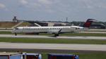
FloridaMetal
@ KATL
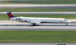
FloridaMetal
@ KATL
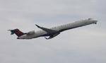
FloridaMetal
@ KATL
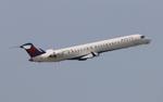
FloridaMetal
@ KATL
Recent Routes
IN FLIGHT
EDV5141
| Time | Callsign | FL | Speed | Heading | Route |
|---|---|---|---|---|---|
| 2026-11-20 21:36 UTC | EDV5141 | FL48 | 279 kt | 127° | — |
| 2026-11-20 19:10 UTC | EDV5303 | FL-1 | 138 kt | 209° |
PIT → DTW
PIT
→
DTW
Pittsburgh International Airport → Detroit Metro Wayne County Airport |
| 2026-11-20 16:36 UTC | EDV5086 | FL10 | 136 kt | 272° |
JFK → PIT
JFK
→
PIT
John F Kennedy International Airport → Pittsburgh International Airport |
| 2026-11-20 13:42 UTC | EDV5239 | FL-4 | 130 kt | 211° |
RDU → JFK
RDU
→
JFK
Raleigh-durham International Airport → John F Kennedy International Airport |
| 2026-11-20 03:54 UTC | EDV4648 | — | 136 kt | 45° | — |
| 2026-11-20 00:24 UTC | EDV5408 | FL56 | 259 kt | 252° |
JFK → 21MO
JFK
→
21MO
John F Kennedy International Airport → Baker Farm Airport |
| 2026-11-19 20:30 UTC | EDV5039 | — | 12 kt | 121° | — |
| 2026-11-19 12:52 UTC | EDV5176 | — | 16 kt | 121° | — |
| 2026-11-19 03:56 UTC | EDV5082 | FL3 | 130 kt | 130° | — |
| 2026-11-18 23:40 UTC | EDV4643 | FL297 | 117 kt | 209° | — |
| 2026-11-18 21:34 UTC | EDV4680 | FL1 | 129 kt | 330° |
MSP → HPN
MSP
→
HPN
Minneapolis-st Paul Intl/wold-chamberlain Airport → Westchester County Airport |
| 2026-11-18 17:56 UTC | EDV4998 | — | 1 kt | 217° |
MSP → DSM
MSP
→
DSM
Minneapolis-st Paul Intl/wold-chamberlain Airport → Des Moines International Airport |
| 2026-11-18 13:48 UTC | EDV5384 | — | 1 kt | 217° | — |
| 2026-11-18 02:40 UTC | EDV4934 | FL13 | 125 kt | 171° | — |
| 2026-11-18 00:40 UTC | EDV5053 | — | 1 kt | 239° | — |
| 2026-11-17 21:56 UTC | EDV5128 | FL11 | 131 kt | 160° | — |
| 2026-11-17 19:16 UTC | EDV5526 | — | 6 kt | 76° | — |
| 2026-11-17 13:56 UTC | EDV5525 | — | 0 kt | 281° | — |
| 2026-11-17 04:18 UTC | EDV5535 | FL2 | 121 kt | 39° | — |
| 2026-11-17 01:16 UTC | EDV5314 | FL84 | 0 kt | 248° | — |
| 2026-11-16 20:06 UTC | EDV5312 | — | 22 kt | 270° | — |
| 2026-11-16 16:02 UTC | EDV4640 | — | 15 kt | 90° |
CAE → ATL
CAE
→
ATL
Columbia Metro Airport → Hartsfield/jackson Atlanta International Airport |
| 2026-11-16 14:10 UTC | EDV4655 | FL441 | 169 kt | 63° | — |
| 2026-11-16 03:12 UTC | EDV4997 | — | 10 kt | 180° | — |
| 2026-11-15 21:30 UTC | EDV4629 | — | 16 kt | 90° | — |
| 2026-11-15 19:38 UTC | EDV5021 | FL6 | 138 kt | 1° | — |
| 2026-11-15 15:08 UTC | EDV5494 | FL4 | 135 kt | 28° | — |
| 2026-11-14 21:24 UTC | EDV4705 | FL9 | 140 kt | 311° | — |
| 2026-11-14 18:32 UTC | EDV5453 | FL7 | 136 kt | 29° |
SDF → DTW
SDF
→
DTW
Louisville Muhammad Ali International Airport → Detroit Metro Wayne County Airport |
| 2026-11-14 16:20 UTC | EDV5441 | FL4 | 145 kt | 165° | — |
| 2026-11-13 21:02 UTC | EDV5287 | FL8 | 132 kt | 29° | — |
| 2026-11-13 17:04 UTC | EDV5080 | FL8 | 132 kt | 29° |
JFK → DTW
JFK
→
DTW
John F Kennedy International Airport → Detroit Metro Wayne County Airport |
| 2026-11-13 04:26 UTC | EDV5151 | FL6 | 126 kt | 30° |
BGR → JFK
BGR
→
JFK
Bangor International Airport → John F Kennedy International Airport |
| 2026-11-12 20:42 UTC | EDV5262 | FL5 | 135 kt | 31° | — |
| 2026-11-12 16:38 UTC | EDV5230 | FL19 | 131 kt | 12° |
RDU → 1MU2
RDU
→
1MU2
Raleigh-durham International Airport → Smitty's Landing Airport |
| 2026-11-12 13:02 UTC | EDV5244 | — | 60 kt | 225° |
LGA → RDU
LGA
→
RDU
Laguardia Airport → Raleigh-durham International Airport |
| 2026-11-12 03:48 UTC | EDV4966 | — | 1 kt | 326° |
BNA → LGA
BNA
→
LGA
Nashville International Airport → Laguardia Airport |
| 2026-11-12 00:58 UTC | EDV5152 | — | 6 kt | 172° | — |
| 2026-11-11 17:22 UTC | EDV5042 | — | 78 kt | 228° |
LGA → RDU
LGA
→
RDU
Laguardia Airport → Raleigh-durham International Airport |
| 2026-11-11 14:40 UTC | EDV5295 | — | 6 kt | 256° | — |
| 2026-11-11 05:12 UTC | EDV4900 | FL14 | 131 kt | 144° | — |
| 2026-11-11 01:18 UTC | EDV5048 | — | 1 kt | 135° |
LGA → CLT
LGA
→
CLT
Laguardia Airport → Charlotte/douglas International Airport |
| 2026-11-10 22:38 UTC | EDV5491 | FL5 | 136 kt | 165° | — |
| 2026-11-10 04:50 UTC | EDV5567 | FL7 | 115 kt | 209° | — |
| 2026-11-09 01:18 UTC | EDV5351 | — | 3 kt | 211° |
STL → MSP
STL
→
MSP
St Louis Lambert International Airport → Minneapolis-st Paul Intl/wold-chamberlain Airport |
| 2026-11-08 20:04 UTC | EDV4964 | — | 0 kt | 205° | — |
| 2026-11-08 12:38 UTC | EDV4702 | — | 0 kt | 211° |
RST → MSP
RST
→
MSP
Rochester International Airport → Minneapolis-st Paul Intl/wold-chamberlain Airport |
| 2026-11-08 05:52 UTC | EDV4706 | — | 0 kt | 73° |
MSP → RST
MSP
→
RST
Minneapolis-st Paul Intl/wold-chamberlain Airport → Rochester International Airport |
| 2026-11-07 20:52 UTC | EDV5492 | — | 3 kt | 194° | — |
| 2026-11-07 18:08 UTC | EDV5430 | FL11 | 143 kt | 180° |
MSP → OKC
MSP
→
OKC
Minneapolis-st Paul Intl/wold-chamberlain Airport → Okc Will Rogers International Airport |
| 2026-11-07 15:24 UTC | EDV4951 | — | 1 kt | 214° | — |
| 2026-11-07 04:34 UTC | EDV4965 | FL3 | 142 kt | 38° |
MSP → ORF
MSP
→
ORF
Minneapolis-st Paul Intl/wold-chamberlain Airport → Norfolk International Airport |
| 2026-11-06 19:44 UTC | EDV5011 | — | 3 kt | 217° | — |
| 2026-11-06 14:42 UTC | EDV5427 | — | 1 kt | 233° |
YUL → MSP
YUL
→
MSP
Montreal / Pierre Elliott Trudeau International Airport → Minneapolis-st Paul Intl/wold-chamberlain Airport |
| 2026-11-06 04:04 UTC | EDV5489 | — | 16 kt | 132° |
MSP → YUL
MSP
→
YUL
Minneapolis-st Paul Intl/wold-chamberlain Airport → Montreal / Pierre Elliott Trudeau International Airport |
| 2026-11-06 00:12 UTC | EDV4906 | — | 3 kt | 214° |
MSP → CID
MSP
→
CID
Minneapolis-st Paul Intl/wold-chamberlain Airport → The Eastern Iowa Airport |
| 2026-11-05 19:26 UTC | EDV5159 | — | 8 kt | 301° |
GRB → MSP
GRB
→
MSP
Green Bay/austin Straubel International Airport → Minneapolis-st Paul Intl/wold-chamberlain Airport |
| 2026-11-05 15:32 UTC | EDV5523 | — | 0 kt | 219° |
TYS → MSP
TYS
→
MSP
Mc Ghee Tyson Airport → Minneapolis-st Paul Intl/wold-chamberlain Airport |
| 2026-11-04 22:22 UTC | EDV5175 | FL15 | 148 kt | 225° | — |
| 2026-11-04 20:38 UTC | EDV4650 | — | 12 kt | 0° | — |
| 2026-11-04 14:00 UTC | EDV5225 | — | 6 kt | 180° | — |
| 2026-11-04 01:06 UTC | EDV5246 | FL1 | 144 kt | 168° | — |
| 2026-11-03 22:58 UTC | EDV4663 | — | 6 kt | 270° | — |
| 2026-11-03 18:08 UTC | EDV5084 | — | 0 kt | 281° |
ABY → ATL
ABY
→
ATL
Southwest Georgia Regional Airport → Hartsfield/jackson Atlanta International Airport |
| 2026-11-03 12:44 UTC | EDV4691 | — | 15 kt | 0° |
ABY → ATL
ABY
→
ATL
Southwest Georgia Regional Airport → Hartsfield/jackson Atlanta International Airport |
| 2026-11-03 01:54 UTC | EDV5129 | — | 0 kt | 233° |
ATL → ABY
ATL
→
ABY
Hartsfield/jackson Atlanta International Airport → Southwest Georgia Regional Airport |
| 2026-11-02 23:24 UTC | EDV5308 | — | 10 kt | 270° | — |
| 2026-11-02 17:38 UTC | EDV5062 | — | 21 kt | 270° | — |
| 2026-11-02 12:06 UTC | EDV5255 | — | 1 kt | 309° |
VLD → ATL
VLD
→
ATL
Valdosta Regional Airport → Hartsfield/jackson Atlanta International Airport |
| 2026-11-02 02:44 UTC | EDV5443 | FL21 | 196 kt | 152° | — |
| 2026-11-01 22:12 UTC | EDV4654 | — | 1 kt | 248° |
TN98 → ATL
TN98
→
ATL
Sky Ranch Airport → Hartsfield/jackson Atlanta International Airport |
| 2026-11-01 20:06 UTC | EDV5420 | FL2 | 145 kt | 43° | — |
| 2026-11-01 18:10 UTC | EDV5234 | — | 4 kt | 158° | — |
| 2026-10-30 23:34 UTC | EDV5203 | FL13 | 129 kt | 45° | — |
| 2026-10-30 21:30 UTC | EDV5519 | — | 13 kt | 180° | — |
| 2026-10-30 12:56 UTC | EDV4940 | — | 24 kt | 90° | — |
| 2026-10-30 02:58 UTC | EDV5452 | FL162 | 387 kt | 260° | — |
| 2026-10-30 00:32 UTC | EDV4709 | — | 0 kt | 79° | — |
| 2026-10-29 13:00 UTC | EDV5317 | — | 2 kt | 177° | — |
| 2026-10-29 03:24 UTC | EDV5527 | FL13 | 145 kt | 44° |
MSP → TYS
MSP
→
TYS
Minneapolis-st Paul Intl/wold-chamberlain Airport → Mc Ghee Tyson Airport |
| 2026-10-28 22:16 UTC | EDV4693 | — | 1 kt | 211° | — |
| 2026-10-28 18:18 UTC | EDV5435 | FL2 | 139 kt | 150° | — |
| 2026-10-28 15:10 UTC | EDV5214 | — | 13 kt | 39° | — |
| 2026-10-28 11:30 UTC | EDV4661 | — | 0 kt | 270° | — |
| 2026-10-28 03:22 UTC | EDV4669 | FL11 | 142 kt | 230° | — |
| 2026-10-27 00:36 UTC | EDV5278 | — | 0 kt | 90° | — |
| 2026-10-26 22:32 UTC | EDV4665 | FL47 | 185 kt | 340° | — |
| 2026-10-26 19:24 UTC | EDV5482 | — | 12 kt | 225° |
LGA → XNA
LGA
→
XNA
Laguardia Airport → Northwest Arkansas Ntl Airport |
| 2026-10-26 11:56 UTC | EDV5177 | — | 11 kt | 222° |
CLE → LGA
CLE
→
LGA
Cleveland-hopkins International Airport → Laguardia Airport |
| 2026-10-26 02:24 UTC | EDV4946 | FL5 | 136 kt | 230° |
JFK → CLE
JFK
→
CLE
John F Kennedy International Airport → Cleveland-hopkins International Airport |
| 2026-10-25 22:42 UTC | EDV5029 | — | 9 kt | 31° | — |
| 2026-10-25 19:54 UTC | EDV4971 | FL8 | 144 kt | 92° | — |
| 2026-10-25 16:10 UTC | EDV5286 | — | 1 kt | 203° |
MSP → STL
MSP
→
STL
Minneapolis-st Paul Intl/wold-chamberlain Airport → St Louis Lambert International Airport |
| 2026-10-24 00:08 UTC | EDV4958 | — | 4 kt | 273° | — |
| 2026-10-23 18:16 UTC | EDV4707 | — | 0 kt | 270° |
ATL → SGF
ATL
→
SGF
Hartsfield/jackson Atlanta International Airport → Springfield-branson Ntl Airport |
| 2026-10-23 12:30 UTC | EDV4927 | — | 0 kt | 312° | — |
| 2026-10-23 02:40 UTC | EDV5074 | FL106 | 310 kt | 267° | — |
| 2026-10-23 01:06 UTC | EDV5282 | — | 0 kt | 270° | — |
| 2026-10-22 21:40 UTC | EDV5466 | — | 0 kt | 281° | — |
| 2026-10-22 17:36 UTC | EDV5236 | — | 0 kt | 270° | — |
| 2026-10-22 00:22 UTC | EDV4633 | — | 3 kt | 90° | — |
Live location data from OpenSky Network
Airframe Info
| Manufacturer | Bombardier |
| Model | CRJ-900LR (CL-600-2D24) Search all Bombardier CRJ-900LR (CL-600-2D24) |
| Year built | 2008 |
| Construction Number (C/N) | 15174 |
| Aircraft Type | Fixed wing multi engine |
| Number of Engines | 2 |
| Engine Type | Turbofan |
| Engine Manufacturer and Model | Ge CF34-8C5 |
Aircraft
| Registration Number | N922XJ |
| Mode S (ICAO24) Code | acc7ae |
| Certification Class | Standard |
| Certification Issued | 2009-12-31 |
| Air Worthiness Test | 2008-04-23 |
| Last Action Taken | 2023-08-04 |
| Current Status | Valid |
Owner
| Registration Type | Corporation |
| Owner | DELTA AIR LINES INC |
| Address |
Dept 595 Aircraft Registrations Atlanta, GA 303543743 United States |
| Region | Southern |