Aircraft N925AE Data
1
aircraft record found
N925AE
2005 Embraer ERJ-145LR (EMB-145LR), c/n 14500908
Latest photos of N925AE

Mark Pasqualino
@ KORD

Mark Pasqualino
@ KORD

Florida Metal
@ MIA
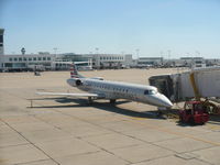
Christian Maurer
@ CVG
Recent Routes
| Time | Callsign | FL | Speed | Heading | Route |
|---|---|---|---|---|---|
| 2026-10-24 22:34 UTC | PDT5918 / PI5918 | FL64 | 230 kt | 73° | — |
| 2026-10-24 19:36 UTC | PDT5940 / PI5940 | FL4 | 134 kt | 357° | — |
| 2026-10-24 13:56 UTC | PDT5937 / PI5937 | FL4 | 128 kt | 356° | — |
| 2026-10-24 09:44 UTC | PDT5963 / PI5963 | FL6 | 131 kt | 356° | — |
| 2026-10-24 03:50 UTC | PDT5836 / PI5836 | FL0 | 121 kt | 348° | — |
| 2026-10-24 01:14 UTC | PDT6044 / PI6044 | FL9 | 127 kt | 356° | — |
| 2026-10-23 22:10 UTC | PDT6042 / PI6042 | — | 57 kt | 357° | — |
| 2026-10-23 19:06 UTC | PDT5992 / PI5992 | FL6 | 133 kt | 356° | — |
| 2026-10-23 14:08 UTC | PDT5794 / PI5794 | FL5 | 125 kt | 357° | — |
| 2026-10-23 03:04 UTC | PDT6130 / PI6130 | FL0 | 126 kt | 314° | — |
| 2026-10-22 22:56 UTC | PDT6024 / PI6024 | FL9 | 132 kt | 357° | — |
| 2026-10-22 19:34 UTC | PDT5946 / PI5946 | FL17 | 132 kt | 355° | — |
| 2026-10-22 16:52 UTC | PDT6075 / PI6075 | FL17 | 131 kt | 356° | — |
| 2026-10-22 11:18 UTC | PDT5834 / PI5834 | FL13 | 124 kt | 356° | — |
| 2026-10-21 02:30 UTC | PDT5819 / PI5819 | FL0 | 122 kt | 307° | — |
| 2026-10-21 00:42 UTC | PDT6082 / PI6082 | — | 22 kt | 340° | — |
| 2026-10-20 23:00 UTC | PDT6104 / PI6104 | FL51 | 193 kt | 353° | — |
| 2026-10-20 20:30 UTC | PDT5896 / PI5896 | FL-2 | 128 kt | 339° | — |
| 2026-10-20 18:22 UTC | PDT6038 / PI6038 | FL75 | 321 kt | 234° |
PHL → K60J
PHL
→
K60J
Philadelphia International Airport → Odell Williamson Municipal Airport |
| 2026-10-20 15:54 UTC | PDT5868 / PI5868 | — | 8 kt | 307° | — |
| 2026-10-20 11:28 UTC | PDT5890 / PI5890 | — | 8 kt | 248° | — |
| 2026-10-20 03:10 UTC | PDT6103 / PI6103 | FL43 | 239 kt | 20° | — |
| 2026-10-20 00:46 UTC | PDT6039 / PI6039 | — | 14 kt | 338° | — |
| 2026-10-19 22:16 UTC | PDT6105 / PI6105 | FL92 | 302 kt | 222° |
PHL → K60J
PHL
→
K60J
Philadelphia International Airport → Odell Williamson Municipal Airport |
| 2026-10-19 19:52 UTC | PDT6054 / PI6054 | FL-4 | 127 kt | 339° |
ROC → PHL
ROC
→
PHL
Frederick Douglass/greater Rochester International Airport → Philadelphia International Airport |
| 2026-10-19 18:20 UTC | PDT5953 / PI5953 | — | 22 kt | 31° |
PHL → ROC
PHL
→
ROC
Philadelphia International Airport → Frederick Douglass/greater Rochester International Airport |
| 2026-10-19 15:48 UTC | PDT5948 / PI5948 | — | 96 kt | 338° | — |
| 2026-10-19 14:10 UTC | PDT6010 / PI6010 | FL-2 | 129 kt | 44° |
PHL → BDL
PHL
→
BDL
Philadelphia International Airport → Bradley International Airport |
| 2026-10-19 00:42 UTC | PDT6033 / PI6033 | — | 7 kt | 250° | — |
| 2026-10-18 20:00 UTC | PDT5804 / PI5804 | — | 8 kt | 253° | — |
| 2026-10-18 17:52 UTC | PDT5847 / PI5847 | FL4 | 134 kt | 223° | — |
| 2026-10-18 16:02 UTC | PDT6015 / PI6015 | — | 19 kt | 338° | — |
| 2026-10-18 14:14 UTC | PDT5904 / PI5904 | FL0 | 138 kt | 358° | — |
| 2026-10-18 11:26 UTC | PDT5930 / PI5930 | — | 21 kt | 340° |
ROC → PHL
ROC
→
PHL
Frederick Douglass/greater Rochester International Airport → Philadelphia International Airport |
| 2026-10-18 01:28 UTC | PDT5816 / PI5816 | — | 11 kt | 28° |
PHL → ROC
PHL
→
ROC
Philadelphia International Airport → Frederick Douglass/greater Rochester International Airport |
| 2026-10-17 22:46 UTC | PDT5809 / PI5809 | — | 9 kt | 262° | — |
| 2026-10-17 21:04 UTC | PDT5935 / PI5935 | FL4 | 136 kt | 44° | — |
| 2026-10-17 19:20 UTC | PDT5800 / PI5800 | — | 8 kt | 293° | — |
| 2026-10-17 14:24 UTC | PDT5844 / PI5844 | — | 11 kt | 250° | — |
| 2026-10-17 12:40 UTC | PDT5796 / PI5796 | FL5 | 125 kt | 359° | — |
| 2026-10-17 00:22 UTC | PDT5884 / PI5884 | — | 10 kt | 340° |
YYZ → PHL
YYZ
→
PHL
Lester B Pearson International Airport → Philadelphia International Airport |
| 2026-10-16 18:32 UTC | PDT5791 / PI5791 | — | 20 kt | 264° | — |
| 2026-10-16 16:18 UTC | PDT6124 / PI6124 | FL22 | 181 kt | 99° | — |
| 2026-10-15 00:40 UTC | PDT5870 / PI5870 | — | 10 kt | 338° | — |
| 2026-10-14 20:50 UTC | PDT5838 / PI5838 | — | 11 kt | 20° | — |
| 2026-10-14 17:40 UTC | PDT6134 / PI6134 | — | 13 kt | 340° | — |
| 2026-10-14 15:58 UTC | PDT6121 / PI6121 | FL5 | 137 kt | 224° | — |
| 2026-10-13 21:50 UTC | PDT5949 / PI5949 | — | 10 kt | 20° | — |
| 2026-10-13 14:42 UTC | PDT6076 / PI6076 | — | 14 kt | 11° | — |
| 2026-10-13 02:54 UTC | PDT5817 / PI5817 | — | 25 kt | 34° |
PHL → ROC
PHL
→
ROC
Philadelphia International Airport → Frederick Douglass/greater Rochester International Airport |
| 2026-10-12 21:28 UTC | PDT5788 / PI5788 | — | 7 kt | 262° | — |
| 2026-10-12 19:40 UTC | PDT6047 / PI6047 | — | 24 kt | 51° |
PHL → CLE
PHL
→
CLE
Philadelphia International Airport → Cleveland-hopkins International Airport |
| 2026-10-12 17:50 UTC | PDT6126 / PI6126 | — | 10 kt | 293° |
ROC → PHL
ROC
→
PHL
Frederick Douglass/greater Rochester International Airport → Philadelphia International Airport |
| 2026-10-12 11:18 UTC | PDT6060 / PI6060 | — | 7 kt | 219° | — |
| 2026-10-12 04:14 UTC | PDT5856 / PI5856 | FL29 | 146 kt | 281° | — |
| 2026-10-12 02:52 UTC | PDT5939 / PI5939 | FL9 | 130 kt | 176° | — |
| 2026-10-11 20:48 UTC | PDT5976 / PI5976 | FL8 | 122 kt | 176° | — |
| 2026-10-11 18:56 UTC | PDT5866 / PI5866 | FL16 | 122 kt | 225° |
ORH → PHL
ORH
→
PHL
Worcester Regional Airport → Philadelphia International Airport |
| 2026-10-11 11:16 UTC | PDT5815 / PI5815 | FL-3 | 132 kt | 339° | — |
| 2026-10-11 01:50 UTC | PDT5805 / PI5805 | FL10 | 169 kt | 336° | — |
| 2026-10-11 00:08 UTC | PDT5974 / PI5974 | — | 22 kt | 340° | — |
| 2026-10-10 20:26 UTC | PDT5951 / PI5951 | — | 12 kt | 281° | — |
| 2026-10-10 17:28 UTC | PDT5853 / PI5853 | — | 10 kt | 250° | — |
| 2026-10-10 13:50 UTC | PDT5928 / PI5928 | FL47 | 197 kt | 340° | — |
| 2026-10-10 11:46 UTC | PDT5897 / PI5897 | FL10 | 133 kt | 356° |
ROA → CLT
ROA
→
CLT
Roanoke/blacksburg Regional (woodrum Fld) Airport → Charlotte/douglas International Airport |
| 2026-10-10 00:20 UTC | PDT6028 / PI6028 | — | 10 kt | 239° | — |
| 2026-10-09 21:52 UTC | PDT6006 / PI6006 | FL7 | 139 kt | 356° | — |
| 2026-10-09 16:58 UTC | PDT6008 / PI6008 | FL6 | 136 kt | 356° |
CLT → KEBD
CLT
→
KEBD
Charlotte/douglas International Airport → Southern West Virginia Regional Airport |
| 2026-10-09 13:50 UTC | PDT5982 / PI5982 | FL9 | 138 kt | 357° | — |
| 2026-10-09 03:04 UTC | PDT5869 / PI5869 | FL1 | 134 kt | 168° | — |
| 2026-10-09 01:14 UTC | PDT6118 / PI6118 | FL6 | 131 kt | 176° | — |
| 2026-10-08 19:52 UTC | PDT6050 / PI6050 | — | 32 kt | 23° | — |
| 2026-10-08 18:00 UTC | PDT5908 / PI5908 | FL11 | 138 kt | 229° |
PHL → ROA
PHL
→
ROA
Philadelphia International Airport → Roanoke/blacksburg Regional (woodrum Fld) Airport |
| 2026-10-08 15:46 UTC | PDT5818 / PI5818 | — | 12 kt | 20° | — |
| 2026-10-08 14:02 UTC | PDT5973 / PI5973 | FL14 | 134 kt | 317° | — |
| 2026-10-08 01:00 UTC | PDT5964 / PI5964 | FL9 | 146 kt | 356° | — |
| 2026-10-07 20:40 UTC | PDT6088 / PI6088 | — | 16 kt | 93° | — |
| 2026-10-07 17:12 UTC | PDT5956 / PI5956 | FL7 | 137 kt | 355° | — |
| 2026-10-07 15:36 UTC | PDT5855 / PI5855 | FL19 | 135 kt | 104° | — |
| 2026-10-07 12:46 UTC | PDT5789 / PI5789 | FL-1 | 137 kt | 339° | — |
| 2026-10-07 01:30 UTC | PDT5810 / PI5810 | FL4 | 132 kt | 336° | — |
| 2026-10-06 23:34 UTC | PDT5886 / PI5886 | — | 10 kt | 284° |
PHL → YYZ
PHL
→
YYZ
Philadelphia International Airport → Lester B Pearson International Airport |
| 2026-10-06 18:40 UTC | PDT6062 / PI6062 | FL-2 | 108 kt | 339° | — |
| 2026-10-05 18:56 UTC | PDT6097 / PI6097 | FL14 | 136 kt | 44° | — |
| 2026-10-05 16:44 UTC | PDT5795 / PI5795 | FL7 | 142 kt | 356° | — |
| 2026-10-05 01:10 UTC | PDT5968 / PI5968 | FL10 | 135 kt | 356° | — |
| 2026-10-04 13:26 UTC | PDT5905 / PI5905 | FL9 | 144 kt | 356° | — |
| 2026-10-03 23:54 UTC | PDT6086 / PI6086 | FL8 | 134 kt | 359° | — |
| 2026-10-03 19:46 UTC | PDT5995 / PI5995 | — | 53 kt | 357° | — |
| 2026-10-03 14:34 UTC | PDT6071 / PI6071 | FL6 | 134 kt | 176° | — |
| 2026-10-03 13:36 UTC | PDT5891 / PI5891 | FL141 | 349 kt | 115° | — |
| 2026-10-03 00:30 UTC | PDT6005 / PI6005 | FL6 | 130 kt | 176° | — |
| 2026-10-02 16:14 UTC | PDT6083 / PI6083 | FL6 | 130 kt | 176° | — |
| 2026-10-02 11:16 UTC | PDT5790 / PI5790 | — | 18 kt | 354° | — |
| 2026-10-02 02:40 UTC | PDT5865 / PI5865 | FL12 | 155 kt | 32° | — |
| 2026-10-01 19:28 UTC | PDT5826 / PI5826 | FL16 | 166 kt | 356° |
ROA → CLT
ROA
→
CLT
Roanoke/blacksburg Regional (woodrum Fld) Airport → Charlotte/douglas International Airport |
| 2026-10-01 15:14 UTC | PDT6048 / PI6048 | FL14 | 148 kt | 356° | — |
| 2026-09-30 17:00 UTC | PDT5871 / PI5871 | — | 15 kt | 340° | — |
| 2026-09-30 00:06 UTC | PDT6064 / PI6064 | — | 13 kt | 340° | — |
| 2026-09-29 18:24 UTC | PDT6079 / PI6079 | — | 7 kt | 231° | — |
| 2026-09-29 13:14 UTC | PDT5787 / PI5787 | FL7 | 129 kt | 356° | — |
| 2026-09-29 01:30 UTC | PDT6074 / PI6074 | FL41 | 231 kt | 277° | — |
| 2026-09-28 18:26 UTC | PDT5983 / PI5983 | FL12 | 134 kt | 355° | — |
| 2026-09-28 15:32 UTC | PDT5942 / PI5942 | FL8 | 129 kt | 356° | — |
| 2026-09-28 13:32 UTC | PDT5980 / PI5980 | FL29 | 166 kt | 37° | — |
| 2026-09-28 11:06 UTC | PDT5917 / PI5917 | FL11 | 126 kt | 356° | — |
| 2026-09-28 04:36 UTC | PDT5903 / PI5903 | FL4 | 127 kt | 237° | — |
| 2026-09-28 00:58 UTC | PDT5959 / PI5959 | — | 21 kt | 25° | — |
| 2026-09-27 21:44 UTC | PDT5970 / PI5970 | FL13 | 138 kt | 355° | — |
| 2026-09-27 18:20 UTC | PDT6004 / PI6004 | FL9 | 145 kt | 356° | — |
| 2026-09-27 14:08 UTC | PDT5943 / PI5943 | FL11 | 135 kt | 356° | — |
| 2026-09-27 10:08 UTC | PDT5848 / PI5848 | FL9 | 122 kt | 356° | — |
| 2026-09-27 00:46 UTC | PDT5842 / PI5842 | FL11 | 112 kt | 356° | — |
| 2026-09-26 20:46 UTC | PDT5988 / PI5988 | FL9 | 127 kt | 356° | — |
| 2026-09-26 19:32 UTC | PDT8844 / PI8844 | FL10 | 141 kt | 212° | — |
| 2026-09-26 11:00 UTC | PDT5934 / PI5934 | — | 9 kt | 340° | — |
| 2026-09-25 23:30 UTC | PDT6073 / PI6073 | FL8 | 142 kt | 296° | — |
| 2026-09-25 20:02 UTC | PDT6128 / PI6128 | FL8 | 140 kt | 356° | — |
| 2026-09-25 15:16 UTC | PDT6094 / PI6094 | FL10 | 140 kt | 357° | — |
| 2026-09-25 11:26 UTC | PDT5915 / PI5915 | FL7 | 128 kt | 356° | — |
| 2026-09-25 02:06 UTC | PDT5879 / PI5879 | FL3 | 127 kt | 54° | — |
Live location data from OpenSky Network
Airframe Info
| Manufacturer | Embraer |
| Model | ERJ-145LR (EMB-145LR) Search all Embraer ERJ-145LR (EMB-145LR) |
| Year built | 2005 |
| Construction Number (C/N) | 14500908 |
| Aircraft Type | Fixed wing multi engine |
| Number of Seats | 55 |
| Number of Engines | 2 |
| Engine Type | Turbofan |
| Engine Manufacturer and Model | Rolls-royc AE3007 SER |
Aircraft
| Registration Number | N925AE |
| Mode S (ICAO24) Code | acd0c2 |
| Certification Class | Standard |
| Certification Issued | 2011-10-17 |
| Air Worthiness Test | 2005-04-30 |
| Last Action Taken | 2023-03-24 |
| Current Status | Valid |
Owner
| Registration Type | Corporation |
| Owner | AMERICAN AIRLINES INC |
| Address |
Md 8b369 Fort Worth, TX 76155 United States |
| Region | Southwestern |