Aircraft N929XJ Data
1
aircraft record found
N929XJ
2008 Bombardier CRJ-900ER (CL-600-2D24), c/n 15191
Latest photos of N929XJ

AviationLover50
@ KATL
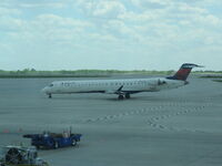
30295
@ 1050
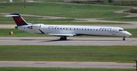
Florida Metal
@ KDTW

Florida Metal
@ DTW
Recent Routes
NO LIVE DATA
| Time | Callsign | FL | Speed | Heading | Route |
|---|---|---|---|---|---|
| 2026-10-24 01:18 UTC | EDV4972 | — | 0 kt | 326° | — |
| 2026-10-23 20:20 UTC | EDV4931 | — | 10 kt | 222° | — |
| 2026-10-23 14:12 UTC | EDV5210 | — | 9 kt | 222° | — |
| 2026-10-23 01:40 UTC | EDV5386 | — | 17 kt | 51° | — |
| 2026-10-22 23:00 UTC | EDV4935 | FL5 | 137 kt | 29° | — |
| 2026-10-22 17:32 UTC | EDV5327 | FL5 | 140 kt | 29° | — |
| 2026-10-22 13:00 UTC | EDV4887 | FL4 | 148 kt | 209° | — |
| 2026-10-22 01:00 UTC | EDV5180 | FL7 | 133 kt | 262° | — |
| 2026-10-21 12:56 UTC | EDV5092 | FL4 | 147 kt | 208° | — |
| 2026-10-21 01:42 UTC | EDV5433 | FL3 | 120 kt | 327° | — |
| 2026-10-20 22:34 UTC | EDV4634 | FL4 | 144 kt | 208° | — |
| 2026-10-20 20:34 UTC | EDV4923 | FL3 | 150 kt | 165° | — |
| 2026-10-20 17:32 UTC | EDV5061 | — | 0 kt | 326° | — |
| 2026-10-20 11:50 UTC | EDV4948 | — | 8 kt | 222° | — |
| 2026-10-20 02:08 UTC | EDV5517 | FL6 | 135 kt | 0° | — |
| 2026-10-19 23:06 UTC | EDV5455 | — | 4 kt | 307° | — |
| 2026-10-19 16:48 UTC | EDV5024 | — | 0 kt | 132° |
LGA → RDU
LGA
→
RDU
Laguardia Airport → Raleigh-durham International Airport |
| 2026-10-19 11:52 UTC | EDV5292 | — | 4 kt | 253° | — |
| 2026-10-19 02:58 UTC | EDV5118 | FL20 | 118 kt | 45° | — |
| 2026-10-19 00:54 UTC | EDV5054 | — | 4 kt | 312° |
ROC → LGA
ROC
→
LGA
Frederick Douglass/greater Rochester International Airport → Laguardia Airport |
| 2026-10-18 21:08 UTC | EDV4956 | — | 6 kt | 191° |
LGA → RDU
LGA
→
RDU
Laguardia Airport → Raleigh-durham International Airport |
| 2026-10-18 18:38 UTC | EDV5042 | FL0 | 128 kt | 45° |
LGA → RDU
LGA
→
RDU
Laguardia Airport → Raleigh-durham International Airport |
| 2026-10-18 16:22 UTC | EDV5153 | — | 1 kt | 298° |
LGA → K60J
LGA
→
K60J
Laguardia Airport → Odell Williamson Municipal Airport |
| 2026-10-18 11:24 UTC | EDV5217 | — | 6 kt | 222° | — |
| 2026-10-18 03:16 UTC | EDV5082 | FL1 | 135 kt | 311° | — |
| 2026-10-17 23:38 UTC | EDV5033 | FL3 | 128 kt | 209° | — |
| 2026-10-17 18:50 UTC | EDV5499 | FL3 | 143 kt | 209° | — |
| 2026-10-17 16:24 UTC | EDV5509 | FL14 | 122 kt | 328° | — |
| 2026-10-17 12:54 UTC | EDV5232 | FL3 | 132 kt | 29° | — |
| 2026-10-17 00:26 UTC | EDV5249 | FL56 | 277 kt | 244° | — |
| 2026-10-16 22:20 UTC | EDV5350 | FL7 | 130 kt | 29° | — |
| 2026-10-16 20:22 UTC | EDV5299 | — | 0 kt | 59° |
JFK → ROC
JFK
→
ROC
John F Kennedy International Airport → Frederick Douglass/greater Rochester International Airport |
| 2026-10-16 17:28 UTC | EDV4929 | FL3 | 138 kt | 210° | — |
| 2026-10-16 14:28 UTC | EDV4903 | — | 12 kt | 270° |
JFK → ORD
JFK
→
ORD
John F Kennedy International Airport → Chicago O'hare International Airport |
| 2026-10-16 01:10 UTC | EDV5250 | FL-2 | 127 kt | 211° | — |
| 2026-10-15 21:16 UTC | EDV4662 | FL-2 | 136 kt | 211° |
JFK → BNA
JFK
→
BNA
John F Kennedy International Airport → Nashville International Airport |
| 2026-10-15 14:24 UTC | EDV4916 | — | 23 kt | 301° |
BNA → JFK
BNA
→
JFK
Nashville International Airport → John F Kennedy International Airport |
| 2026-10-15 03:30 UTC | EDV4908 | — | 15 kt | 309° |
JFK → BNA
JFK
→
BNA
John F Kennedy International Airport → Nashville International Airport |
| 2026-10-14 23:00 UTC | EDV5399 | FL2 | 130 kt | 301° | — |
| 2026-10-14 18:48 UTC | EDV4976 | — | 16 kt | 169° |
JFK → IND
JFK
→
IND
John F Kennedy International Airport → Indianapolis International Airport |
| 2026-10-14 12:58 UTC | EDV4932 | — | 15 kt | 166° | — |
| 2026-10-14 00:22 UTC | EDV4914 | FL9 | 132 kt | 224° |
JFK → IND
JFK
→
IND
John F Kennedy International Airport → Indianapolis International Airport |
| 2026-10-13 20:54 UTC | EDV5035 | FL1 | 103 kt | 211° |
ORD → JFK
ORD
→
JFK
Chicago O'hare International Airport → John F Kennedy International Airport |
| 2026-10-13 17:12 UTC | EDV5119 | FL7 | 17 kt | 90° |
JFK → ORD
JFK
→
ORD
John F Kennedy International Airport → Chicago O'hare International Airport |
| 2026-10-13 13:16 UTC | EDV4959 | — | 13 kt | 211° | — |
| 2026-10-13 01:12 UTC | EDV5123 | FL1 | 149 kt | 250° | — |
| 2026-10-12 21:40 UTC | EDV5348 | FL2 | 142 kt | 31° | — |
| 2026-10-12 19:40 UTC | EDV5465 | FL29 | 224 kt | 171° | — |
| 2026-10-12 17:50 UTC | EDV5272 | FL11 | 130 kt | 209° | — |
| 2026-10-12 15:16 UTC | EDV4897 | FL10 | 131 kt | 209° | — |
| 2026-10-12 13:42 UTC | EDV5209 | FL9 | 129 kt | 224° | — |
| 2026-10-11 20:18 UTC | EDV4896 | FL8 | 136 kt | 30° | — |
| 2026-10-11 17:30 UTC | EDV5547 | FL8 | 135 kt | 45° | — |
| 2026-10-11 14:28 UTC | EDV5124 | FL17 | 132 kt | 144° | — |
| 2026-10-11 11:08 UTC | EDV5031 | FL7 | 142 kt | 28° |
YYZ → DTW
YYZ
→
DTW
Lester B Pearson International Airport → Detroit Metro Wayne County Airport |
| 2026-10-10 20:08 UTC | EDV5233 | — | 0 kt | 90° |
LGA → YYZ
LGA
→
YYZ
Laguardia Airport → Lester B Pearson International Airport |
| 2026-10-09 23:54 UTC | EDV4895 | FL6 | 138 kt | 209° | — |
| 2026-10-09 20:54 UTC | EDV5128 | FL14 | 147 kt | 160° | — |
| 2026-10-09 18:42 UTC | EDV4955 | — | 0 kt | 110° | — |
| 2026-10-09 14:52 UTC | EDV5309 | — | 4 kt | 96° | — |
| 2026-10-09 11:10 UTC | EDV5462 | — | 6 kt | 39° | — |
| 2026-10-09 02:46 UTC | EDV5515 | FL2 | 139 kt | 212° | — |
| 2026-10-09 00:28 UTC | EDV5161 | — | 1 kt | 270° | — |
| 2026-10-08 20:54 UTC | EDV5365 | — | 2 kt | 90° |
ROA → ATL
ROA
→
ATL
Roanoke/blacksburg Regional (woodrum Fld) Airport → Hartsfield/jackson Atlanta International Airport |
| 2026-10-08 18:32 UTC | EDV5227 | FL11 | 135 kt | 230° |
ATL → ROA
ATL
→
ROA
Hartsfield/jackson Atlanta International Airport → Roanoke/blacksburg Regional (woodrum Fld) Airport |
| 2026-10-08 16:16 UTC | EDV5062 | — | 3 kt | 270° | — |
| 2026-10-08 12:16 UTC | EDV5317 | — | 6 kt | 276° | — |
| 2026-10-08 00:32 UTC | EDV5003 | FL12 | 134 kt | 225° | — |
| 2026-10-07 21:34 UTC | EDV5380 | — | 10 kt | 186° | — |
| 2026-10-07 19:02 UTC | EDV5242 | — | 16 kt | 51° |
LGA → CLE
LGA
→
CLE
Laguardia Airport → Cleveland-hopkins International Airport |
| 2026-10-07 02:42 UTC | EDV5393 | FL5 | 133 kt | 311° | — |
| 2026-10-07 00:44 UTC | EDV5038 | — | 0 kt | 312° | — |
| 2026-10-06 23:14 UTC | EDV5261 | FL130 | 369 kt | 88° | — |
| 2026-10-06 20:26 UTC | EDV4953 | — | 6 kt | 79° |
ATL → KM95
ATL
→
KM95
Hartsfield/jackson Atlanta International Airport → Richard Arthur Fld Airport |
| 2026-10-06 15:42 UTC | EDV5142 | — | 0 kt | 278° | — |
| 2026-10-06 11:28 UTC | EDV5349 | — | 0 kt | 309° | — |
| 2026-10-06 03:04 UTC | EDV5206 | FL44 | 227 kt | 35° | — |
| 2026-10-05 20:56 UTC | EDV5051 | — | 6 kt | 132° |
ATL → ROA
ATL
→
ROA
Hartsfield/jackson Atlanta International Airport → Roanoke/blacksburg Regional (woodrum Fld) Airport |
| 2026-10-05 16:36 UTC | EDV5070 | — | 0 kt | 110° |
ATL → ROA
ATL
→
ROA
Hartsfield/jackson Atlanta International Airport → Roanoke/blacksburg Regional (woodrum Fld) Airport |
| 2026-10-05 12:28 UTC | EDV4927 | — | 8 kt | 11° | — |
| 2026-10-05 02:26 UTC | EDV5074 | FL141 | 337 kt | 248° | — |
| 2026-10-05 00:58 UTC | EDV5376 | — | 2 kt | 90° | — |
| 2026-10-04 21:16 UTC | EDV5231 | — | 8 kt | 0° | — |
| 2026-10-04 19:06 UTC | EDV5021 | FL6 | 151 kt | 181° | — |
| 2026-10-04 16:38 UTC | EDV5354 | FL7 | 138 kt | 209° | — |
| 2026-10-04 11:36 UTC | EDV5165 | — | 26 kt | 118° | — |
| 2026-10-04 01:10 UTC | EDV4898 | FL6 | 130 kt | 44° | — |
| 2026-10-03 22:46 UTC | EDV5130 | FL5 | 149 kt | 28° | — |
| 2026-10-03 17:30 UTC | EDV5287 | FL3 | 132 kt | 29° | — |
| 2026-10-03 15:36 UTC | EDV5100 | — | 0 kt | 59° | — |
| 2026-10-03 12:44 UTC | EDV4652 | FL3 | 124 kt | 28° | — |
| 2026-10-03 01:58 UTC | EDV4894 | FL9 | 152 kt | 197° | — |
| 2026-10-02 22:44 UTC | EDV5278 | FL6 | 136 kt | 29° | — |
| 2026-10-02 19:38 UTC | EDV5328 | FL45 | 270 kt | 24° | — |
| 2026-10-02 17:30 UTC | EDV5207 | FL1 | 115 kt | 211° | — |
| 2026-10-02 11:10 UTC | EDV5277 | — | 80 kt | 211° | — |
| 2026-10-02 03:26 UTC | EDV5411 | FL14 | 117 kt | 276° | — |
| 2026-10-01 22:46 UTC | EDV5395 | FL1 | 138 kt | 121° | — |
| 2026-10-01 17:44 UTC | EDV5315 | — | 70 kt | 121° |
JFK → 3NY5
JFK
→
3NY5
John F Kennedy International Airport → 3NY5 |
| 2026-10-01 13:14 UTC | EDV5032 | FL-2 | 115 kt | 211° | — |
| 2026-10-01 01:10 UTC | EDV5459 | FL4 | 136 kt | 90° | — |
| 2026-09-30 21:30 UTC | EDV5280 | FL1 | 143 kt | 301° | — |
| 2026-09-30 17:30 UTC | EDV5055 | — | 12 kt | 28° |
MSP → STL
MSP
→
STL
Minneapolis-st Paul Intl/wold-chamberlain Airport → St Louis Lambert International Airport |
| 2026-09-30 12:50 UTC | EDV5080 | FL7 | 132 kt | 209° |
JFK → DTW
JFK
→
DTW
John F Kennedy International Airport → Detroit Metro Wayne County Airport |
| 2026-09-30 06:18 UTC | EDV5262 | FL1 | 122 kt | 301° | — |
| 2026-09-30 02:34 UTC | EDV5558 | FL33 | 135 kt | 204° | — |
| 2026-09-29 22:44 UTC | EDV5027 | FL1 | 147 kt | 211° | — |
| 2026-09-29 20:16 UTC | EDV4971 | FL13 | 146 kt | 317° | — |
| 2026-09-29 17:14 UTC | EDV4705 | — | 2 kt | 208° | — |
| 2026-09-29 12:56 UTC | EDV5523 | — | 1 kt | 208° | — |
| 2026-09-29 00:46 UTC | EDV5203 | FL15 | 136 kt | 45° | — |
| 2026-09-28 23:04 UTC | EDV5377 | — | 12 kt | 0° | — |
| 2026-09-28 19:48 UTC | EDV5418 | — | 5 kt | 267° | — |
| 2026-09-28 15:06 UTC | EDV5497 | — | 0 kt | 273° | — |
| 2026-09-28 02:52 UTC | EDV5159 | FL14 | 138 kt | 160° |
GRB → MSP
GRB
→
MSP
Green Bay/austin Straubel International Airport → Minneapolis-st Paul Intl/wold-chamberlain Airport |
| 2026-09-27 23:32 UTC | EDV4633 | — | 0 kt | 270° | — |
| 2026-09-27 18:16 UTC | EDV5425 | — | 0 kt | 281° | — |
| 2026-09-27 13:24 UTC | EDV5374 | — | 10 kt | 56° | — |
| 2026-09-26 15:14 UTC | EDV5111 | — | 0 kt | 309° | — |
| 2026-09-26 10:50 UTC | EDV5291 | — | 0 kt | 110° | — |
| 2026-09-26 04:38 UTC | EDV5358 | FL3 | 140 kt | 348° | — |
| 2026-09-26 02:40 UTC | EDV5013 | — | 6 kt | 146° | — |
| 2026-09-25 14:46 UTC | EDV5522 | — | 0 kt | 270° | — |
| 2026-09-25 03:32 UTC | EDV5244 | FL9 | 142 kt | 196° | — |
| 2026-09-25 02:54 UTC | EEV5244 | — | 1 kt | 90° | — |
| 2026-09-25 00:34 UTC | EDV5115 | — | 8 kt | 84° | — |
| 2026-09-24 15:34 UTC | EDV5169 | — | 4 kt | 276° |
GRB → MSP
GRB
→
MSP
Green Bay/austin Straubel International Airport → Minneapolis-st Paul Intl/wold-chamberlain Airport |
| 2026-09-24 12:04 UTC | EDV5337 | — | 2 kt | 90° | — |
Live location data from OpenSky Network
Airframe Info
| Manufacturer | Bombardier |
| Model | CRJ-900ER (CL-600-2D24) Search all Bombardier CRJ-900ER (CL-600-2D24) |
| Year built | 2008 |
| Construction Number (C/N) | 15191 |
| Aircraft Type | Fixed wing multi engine |
| Number of Seats | 22 |
| Number of Engines | 2 |
| Engine Type | Turbofan |
| Engine Manufacturer and Model | Ge CF34-8C5 |
| Also Registered As |
G-CFTD
Registered
|
Aircraft
| Registration Number | N929XJ |
| Mode S (ICAO24) Code | ace1af |
| Certification Class | Standard |
| Certification Issued | 2009-12-31 |
| Air Worthiness Test | 2008-07-29 |
| Last Action Taken | 2023-08-04 |
| Current Status | Valid |
Owner
| Registration Type | Corporation |
| Owner | DELTA AIR LINES INC |
| Address |
Dept 595 Aircraft Registrations Atlanta, GA 303543743 United States |
| Region | Southern |