N988AT — 2001 Boeing 717-200 Data
1
aircraft record found
N988AT
2001 Boeing 717-200, c/n 55068
N988AT is a 2001 Boeing 717-200 (serial number 55068). It is configured with 2 engines and 100 seats. Registration status is listed as Valid, with ownership recorded under DELTA AIR LINES INC in Atlanta, GA, United States. The profile includes 51 photos documenting this aircraft.
Latest photos of N988AT

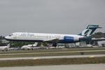
Mark Pasqualino
@ KATL
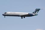
Suncoast Spotter
@ KSRQ
Suncoast Spotter
@ KSRQ
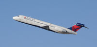
Ryan Hunt
@ RDU
Recent Routes
NO LIVE DATA
Delta Air Lines
| Time | Callsign | FL | Speed | Heading | Route |
|---|---|---|---|---|---|
| 2026-10-30 00:50 UTC | DAL2598 / DL2598 | FL12 | 133 kt | 160° |
ATL → XNA
ATL
→
XNA
Hartsfield/jackson Atlanta International Airport → Northwest Arkansas Ntl Airport |
| 2026-10-29 20:10 UTC | DAL828 / DL828 | — | 3 kt | 98° | — |
| 2026-10-29 13:42 UTC | DAL1007 / DL1007 | — | 0 kt | 270° | — |
| 2026-10-29 03:02 UTC | DAL1880 / DL1880 | FL12 | 127 kt | 160° | — |
| 2026-10-29 00:24 UTC | DAL2060 / DL2060 | — | 0 kt | 270° |
LIT → ATL
LIT
→
ATL
Bill And Hillary Clinton Ntl/adams Fld Airport → Hartsfield/jackson Atlanta International Airport |
| 2026-10-28 19:30 UTC | DAL3182 / DL3182 | — | 8 kt | 180° |
ATL → K38J
ATL
→
K38J
Hartsfield/jackson Atlanta International Airport → K38J |
| 2026-10-28 15:34 UTC | DAL2793 / DL2793 | — | 0 kt | 264° | — |
| 2026-10-27 23:24 UTC | DAL1420 / DL1420 | — | 0 kt | 23° | — |
| 2026-10-27 18:26 UTC | DAL3176 / DL3176 | — | 0 kt | 281° | — |
| 2026-10-26 23:46 UTC | DAL2857 / DL2857 | — | 3 kt | 90° | — |
| 2026-10-26 18:24 UTC | DAL2182 / DL2182 | — | 0 kt | 270° |
ATL → HSV
ATL
→
HSV
Hartsfield/jackson Atlanta International Airport → Huntsville Intl-carl T Jones Fld Airport |
| 2026-10-26 15:06 UTC | DAL418 / DL418 | — | 16 kt | 180° | — |
| 2026-10-26 12:48 UTC | DAL2481 / DL2481 | FL5 | 129 kt | 356° | — |
| 2026-10-26 00:30 UTC | DAL2822 / DL2822 | FL3 | 141 kt | 209° |
STL → DTW
STL
→
DTW
St Louis Lambert International Airport → Detroit Metro Wayne County Airport |
| 2026-10-25 19:58 UTC | DAL1716 / DL1716 | FL3 | 137 kt | 209° | — |
| 2026-10-25 15:38 UTC | DAL1639 / DL1639 | FL3 | 139 kt | 209° | — |
| 2026-10-25 12:40 UTC | DAL2705 / DL2705 | — | 22 kt | 28° |
ATL → CLT
ATL
→
CLT
Hartsfield/jackson Atlanta International Airport → Charlotte/douglas International Airport |
| 2026-10-25 10:20 UTC | DAL1044 / DL1044 | — | 5 kt | 0° | — |
| 2026-10-25 02:34 UTC | DAL1366 / DL1366 | FL7 | 145 kt | 197° | — |
| 2026-10-25 00:10 UTC | DAL3043 / DL3043 | — | 8 kt | 39° | — |
| 2026-10-24 19:30 UTC | DAL2620 / DL2620 | — | 5 kt | 113° | — |
| 2026-10-24 14:10 UTC | DAL0418 / DL418 | — | 4 kt | 93° | — |
| 2026-10-24 00:06 UTC | DAL2813 / DL2813 | FL5 | 133 kt | 356° |
ATL → CLT
ATL
→
CLT
Hartsfield/jackson Atlanta International Airport → Charlotte/douglas International Airport |
| 2026-10-23 22:18 UTC | DAL854 / DL854 | — | 7 kt | 152° | — |
| 2026-10-23 16:52 UTC | DAL2754 / DL2754 | — | 22 kt | 90° | — |
| 2026-10-23 11:10 UTC | DAL2637 / DL2637 | — | 0 kt | 270° |
BNA → ATL
BNA
→
ATL
Nashville International Airport → Hartsfield/jackson Atlanta International Airport |
| 2026-10-23 00:00 UTC | DAL790 / DL790 | — | 2 kt | 96° |
ATL → BNA
ATL
→
BNA
Hartsfield/jackson Atlanta International Airport → Nashville International Airport |
| 2026-10-22 22:06 UTC | DAL2094 / DL2094 | — | 0 kt | 270° |
ATL → DSM
ATL
→
DSM
Hartsfield/jackson Atlanta International Airport → Des Moines International Airport |
| 2026-10-22 15:54 UTC | DAL3164 / DL3164 | — | 2 kt | 68° | — |
| 2026-10-22 12:38 UTC | DAL1183 / DL1183 | — | 4 kt | 87° | — |
| 2026-10-22 02:38 UTC | DAL3111 / DL3111 | — | 2 kt | 256° |
ATL → BTR
ATL
→
BTR
Hartsfield/jackson Atlanta International Airport → Baton Rouge Metro, Ryan Fld Airport |
| 2026-10-21 23:52 UTC | DAL1189 / DL1189 | — | 5 kt | 270° |
ABE → ATL
ABE
→
ATL
Lehigh Valley International Airport → Hartsfield/jackson Atlanta International Airport |
| 2026-10-21 18:26 UTC | DAL1017 / DL1017 | — | 18 kt | 90° | — |
| 2026-10-21 16:30 UTC | 1017 | FL18 | 145 kt | 54° | — |
| 2026-10-21 14:56 UTC | DAL3077 / DL3077 | — | 0 kt | 270° | — |
| 2026-10-21 11:04 UTC | DAL3075 / DL3075 | — | 0 kt | 79° | — |
| 2026-10-21 02:24 UTC | DAL3074 / DL3074 | FL93 | 289 kt | 105° | — |
| 2026-10-20 19:52 UTC | DAL731 / DL731 | — | 4 kt | 90° | — |
| 2026-10-20 15:42 UTC | DAL376 / DL376 | — | 0 kt | 270° | — |
| 2026-10-20 11:22 UTC | DAL3181 / DL3181 | — | 6 kt | 87° | — |
| 2026-10-20 03:28 UTC | DAL3079 / DL3079 | FL2 | 134 kt | 103° | — |
| 2026-10-20 01:44 UTC | DAL2771 / DL2771 | — | 4 kt | 149° | — |
| 2026-10-19 20:26 UTC | DAL3099 / DL3099 | — | 0 kt | 270° | — |
| 2026-10-19 03:48 UTC | DAL3121 / DL3121 | FL3 | 135 kt | 17° |
ATL → BNA
ATL
→
BNA
Hartsfield/jackson Atlanta International Airport → Nashville International Airport |
| 2026-10-19 01:12 UTC | DAL1235 / DL1235 | — | 6 kt | 158° |
ATL → LEX
ATL
→
LEX
Hartsfield/jackson Atlanta International Airport → Blue Grass Airport |
| 2026-10-18 21:14 UTC | DAL3142 / DL3142 | — | 16 kt | 90° |
ATL → BNA
ATL
→
BNA
Hartsfield/jackson Atlanta International Airport → Nashville International Airport |
| 2026-10-18 17:18 UTC | DAL3052 / DL3052 | — | 0 kt | 98° | — |
| 2026-10-18 13:18 UTC | DAL3001 / DL3001 | — | 6 kt | 174° |
BNA → ATL
BNA
→
ATL
Nashville International Airport → Hartsfield/jackson Atlanta International Airport |
| 2026-10-18 10:52 UTC | DAL9961 / DL9961 | — | 14 kt | 301° | — |
| 2026-10-17 22:22 UTC | DAL1868 / DL1868 | — | 0 kt | 281° | — |
| 2026-10-17 14:12 UTC | DAL1883 / DL1883 | — | 3 kt | 8° | — |
| 2026-10-17 03:08 UTC | DAL1577 / DL1577 | FL7 | 121 kt | 359° | — |
| 2026-10-17 00:52 UTC | DAL3053 / DL3053 | — | 3 kt | 90° | — |
| 2026-10-16 20:40 UTC | DAL3010 / DL3010 | — | 12 kt | 68° | — |
| 2026-10-16 17:04 UTC | DAL3190 / DL3190 | — | 0 kt | 278° |
ATL → CLT
ATL
→
CLT
Hartsfield/jackson Atlanta International Airport → Charlotte/douglas International Airport |
| 2026-10-16 12:54 UTC | DAL2216 / DL2216 | FL310 | 478 kt | 113° | — |
| 2026-10-16 03:34 UTC | DAL2959 / DL2959 | FL15 | 127 kt | 20° | — |
| 2026-10-16 00:30 UTC | DAL2193 / DL2193 | — | 3 kt | 270° | — |
| 2026-10-15 20:40 UTC | DAL3195 / DL3195 | — | 17 kt | 180° | — |
| 2026-10-15 16:42 UTC | DAL1590 / DL1590 | — | 1 kt | 278° | — |
| 2026-10-15 12:50 UTC | DAL3155 / DL3155 | — | 1 kt | 90° | — |
| 2026-10-15 02:50 UTC | DAL3178 / DL3178 | FL36 | 278 kt | 241° | — |
| 2026-10-14 23:42 UTC | DAL1762 / DL1762 | — | 3 kt | 90° | — |
| 2026-10-14 20:04 UTC | DAL2718 / DL2718 | — | 0 kt | 287° | — |
| 2026-10-14 16:02 UTC | DAL3047 / DL3047 | — | 4 kt | 42° |
ATL → K38J
ATL
→
K38J
Hartsfield/jackson Atlanta International Airport → K38J |
| 2026-10-14 12:00 UTC | DAL3061 / DL3061 | — | 2 kt | 270° | — |
| 2026-10-13 23:58 UTC | DAL3008 / DL3008 | FL15 | 164 kt | 284° | — |
| 2026-10-13 22:00 UTC | DAL2730 / DL2730 | — | 4 kt | 87° |
ATL → BTR
ATL
→
BTR
Hartsfield/jackson Atlanta International Airport → Baton Rouge Metro, Ryan Fld Airport |
| 2026-10-13 17:26 UTC | DAL3045 / DL3045 | — | 3 kt | 270° | — |
| 2026-10-12 17:20 UTC | DAL3118 / DL3118 | — | 3 kt | 270° | — |
| 2026-10-11 23:58 UTC | DAL3127 / DL3127 | FL9 | 15 kt | 0° | — |
| 2026-10-11 15:46 UTC | DAL2389 / DL2389 | — | 13 kt | 11° |
ATL → 3MS9
ATL
→
3MS9
Hartsfield/jackson Atlanta International Airport → Union Municipal Airport |
| 2026-10-11 11:18 UTC | DAL2953 / DL2953 | — | 6 kt | 76° | — |
| 2026-10-11 02:50 UTC | DAL2435 / DL2435 | FL-1 | 141 kt | 87° | — |
| 2026-10-10 23:04 UTC | DAL1896 / DL1896 | — | 0 kt | 273° | — |
| 2026-10-10 20:02 UTC | DAL1429 / DL1429 | FL8 | 149 kt | 355° | — |
| 2026-10-10 16:48 UTC | DAL2868 / DL2868 | FL5 | 141 kt | 209° |
STL → DTW
STL
→
DTW
St Louis Lambert International Airport → Detroit Metro Wayne County Airport |
| 2026-10-10 11:28 UTC | DAL2596 / DL2596 | FL5 | 141 kt | 209° |
EWR → DTW
EWR
→
DTW
Newark Liberty International Airport → Detroit Metro Wayne County Airport |
| 2026-10-10 03:16 UTC | DAL2609 / DL2609 | — | 0 kt | 287° | — |
| 2026-10-09 22:46 UTC | DAL1821 / DL1821 | — | 14 kt | 28° | — |
| 2026-10-09 17:14 UTC | DAL2826 / DL2826 | FL6 | 134 kt | 209° | — |
| 2026-10-09 11:48 UTC | DAL2601 / DL2601 | — | 6 kt | 200° |
BWI → DTW
BWI
→
DTW
Baltimore/washington International Thurgood Marshall Airport → Detroit Metro Wayne County Airport |
| 2026-10-09 03:40 UTC | DAL2715 / DL2715 | — | 8 kt | 245° | — |
| 2026-10-09 00:14 UTC | DAL2761 / DL2761 | FL7 | 136 kt | 208° | — |
| 2026-10-08 18:42 UTC | DAL2577 / DL2577 | FL7 | 147 kt | 208° | — |
| 2026-10-08 12:56 UTC | DAL2039 / DL2039 | FL8 | 136 kt | 208° | — |
| 2026-10-08 01:10 UTC | DAL1665 / DL1665 | FL9 | 133 kt | 270° | — |
| 2026-10-07 22:24 UTC | DAL2573 / DL2573 | FL10 | 145 kt | 209° |
EWR → DTW
EWR
→
DTW
Newark Liberty International Airport → Detroit Metro Wayne County Airport |
| 2026-10-06 22:46 UTC | DAL1343 / DL1343 | FL7 | 139 kt | 209° | — |
| 2026-10-06 18:46 UTC | DAL2684 / DL2684 | FL7 | 140 kt | 209° | — |
| 2026-10-06 13:06 UTC | DAL1256 / DL1256 | FL6 | 134 kt | 208° | — |
| 2026-10-06 01:36 UTC | DAL1321 / DL1321 | FL25 | 184 kt | 221° | — |
| 2026-10-05 15:20 UTC | DAL3102 / DL3102 | FL5 | 140 kt | 29° | — |
| 2026-10-05 01:28 UTC | DAL1084 / DL1084 | FL6 | 137 kt | 208° |
ORD → DTW
ORD
→
DTW
Chicago O'hare International Airport → Detroit Metro Wayne County Airport |
| 2026-10-04 20:52 UTC | DAL2741 / DL2741 | FL7 | 145 kt | 208° | — |
| 2026-10-03 23:46 UTC | DAL2358 / DL2358 | FL5 | 128 kt | 209° |
ORD → DTW
ORD
→
DTW
Chicago O'hare International Airport → Detroit Metro Wayne County Airport |
| 2026-10-03 18:36 UTC | DAL1627 / DL1627 | FL4 | 138 kt | 29° | — |
| 2026-10-03 12:38 UTC | DAL876 / DL876 | FL4 | 131 kt | 29° | — |
| 2026-10-03 01:26 UTC | DAL1561 / DL1561 | FL8 | 136 kt | 212° | — |
| 2026-09-30 11:38 UTC | DAL1540 / DL1540 | — | 6 kt | 6° |
PHL → DTW
PHL
→
DTW
Philadelphia International Airport → Detroit Metro Wayne County Airport |
Live location data from OpenSky Network
Airframe Info
| Manufacturer | Boeing |
| Model | 717-200 Search all Boeing 717-200 |
| Year built | 2001 |
| Construction Number (C/N) | 55068 |
| Aircraft Type | Fixed wing multi engine |
| Number of Seats | 100 |
| Number of Engines | 2 |
| Engine Type | Turbofan |
| Engine Manufacturer and Model | Rolls-Royce BR715-A1-30 |
| Also Registered As |
Aircraft
| Registration Number | N988AT |
| Mode S (ICAO24) Code | adc8ee |
| Certification Class | Standard |
| Certification Issued | 2024-05-31 |
| Air Worthiness Test | 2002-04-16 |
| Last Action Taken | 2024-05-31 |
| Current Status | Valid |
Owner
| Registration Type | Corporation |
| Owner | DELTA AIR LINES INC |
| Address |
1775 Mh Jackson Service Rd Atlanta, GA 30354 United States |
| Region | Southern |