Lake Norman Airpark Airport (14A)
Lake Norman Airpark Airport (14A)
14A
Lake Norman Airpark Airport (14A)
Mooresville, NC
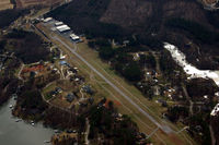
Latest photo of Lake Norman Airpark Airport (14A)
Jamin
| FAA Information Effective | 2026-09-03 |
| Airport Identifier | 14A |
| Airport Status | Operational |
| Longitude/Latitude |
80°53'57.9500"
W /
35°36'49.9300"
N -80.899431 / 35.613869 (Estimated) |
| Elevation | 839.40 ft / 255.85 m (Surveyed) |
| Land | 40 acres |
| From nearest city | 5 nautical miles NW of Mooresville, NC |
| Location | Iredell County, NC |
| Magnetic Variation | 07W (2005) |
| Airport Use | Open to public |
| Wind indicator | Yes |
| Segmented Circle | Yes |
| Control Tower | NON-ATCT |
| Lighting Schedule | SEE RMK |
| Beacon Color | White-Green (lighted land airport) |
| Landing fee charge | No |
| Sectional chart | CHARLOTTE |
| Region | ASO - Southern |
| Responsible ARTCC | ZTL - ATLANTA |
| Tie-in FSS | RDU - RALEIGH |
| FSS on Airport | No |
| FSS Toll Free | 1-800-WX-BRIEF |
| NOTAMs Facility | RDU (NOTAM-d service available) |
Runway 14/32
| Dimensions | 3147 x 40 ft (959 x 12 m) |
| Surface | ASPH (GOOD) |
| Surface treatment | |
| Edge lights | Medium |
| 14 | 32 | |
|---|---|---|
| Physical elevation | 808.00 ft | 839.40 ft |
| Coordinates | 35.617011 / -80.903069 | 35.610728 / -80.895794 |
| Traffic pattern | Left | Left |
| Runway marking | Nonstandard , Good Condition | Nonstandard , Good Condition |
| Runway end lights | No | No |
| CL lights | No | No |
| TDZ lights | No | No |
- ACFT TAXIING ON GRASS INVOF RESIDENTIAL AIRPARK HNGR ACCESS.
- FOR CD CTC APCH AT 704-359-0241. CALL WHEN AT RWY READY FOR DEP.
- CTC RACE CITY FLT OPS FOR TIEDOWN, HNGR, AND FUEL INFO AT 704-662-6227.
- ACFT MAX WT 8000 LBS.
- BACK TAXI ON RWY - NO PARL TWYS.
- NO HEL TRG.
- DEER INVOF RWY.
- RWY 14 HAS UPHILL GRADE.
- DEP RWY 14 HDG 160 DEGS TO AVOID SCHOOL.
- NOISE SENSITIVE AREA AVOID DEPS BTN 2300 AND 0600. DEP RWY 32 HDG 324 DEG UNTIL OVER LAKE TO AVOID HOUSES.
- RWY 32 HAS 10 FT DROP-OFF 5 FT FM LEFT SIDE OF PAVEMENT AND ACFT PARKED 200 FT FM END OF RWY 100 FT RIGHT OF CNTRLN.
- PRVDD VFR; APCH SLOPE SFCS CLEAR FOR 20:1; LTG FOR APCH END RWY 14 CHGD TO SHOW GREEN ON APCH SIDE AND RED ON RWY SIDE; RMK ADDED TO A/FD RE RWY 32 APCH/LDG & LGT; AND HGRS OBSTRUCTION LGTD IF NIGHT APCHS/LDG TO RWY 32 AUTH.