Owyhee Reservoir State Airport (28U)
Owyhee Reservoir State Airport (28U)
28U
Owyhee Reservoir State Airport (28U)
Owyhee, OR
Latest photo of Owyhee Reservoir State Airport (28U)
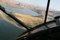
shawn coleman
| FAA Information Effective | 2026-07-09 |
| Airport Identifier | 28U |
| Airport Status | Operational |
| Longitude/Latitude |
117°20'44.4000"
W /
43°25'29.4000"
N -117.345667 / 43.424833 (Estimated) |
| Elevation | 2680.00 ft / 816.86 m (Estimated) |
| Land | 10 acres |
| From nearest city | 25 nautical miles SW of Owyhee, OR |
| Location | Malheur County, OR |
| Magnetic Variation | 17E (1985) |
| Airport Use | Open to public |
| Wind indicator | Yes |
| Segmented Circle | No |
| Control Tower | NON-ATCT |
| Landing fee charge | No |
| Sectional chart | KLAMATH FALLS |
| Region | ANM - Northwest Mountain |
| Responsible ARTCC | ZLC - SALT LAKE CITY |
| Tie-in FSS | MMV - MC MINNVILLE |
| FSS on Airport | No |
| FSS Toll Free | 1-800-WX-BRIEF |
| NOTAMs Facility | MMV (NOTAM-d service available) |
- OWNER ADVISES CONTACT WITH STATE DEPT OF AVIATION 503-378-4880 PRIOR TO USE.
- REMOTE AIRPORT; NO GROUND ACCESS.
- AIRPORT IN CANYON; SURROUNDED BY HIGH TERRAIN.
- 4 FT BRUSH GROWTH WITHIN 20 FT OF RWY EDGE.
- FOR CD CTC SALT LAKE ARTCC AT 801-320-2568.
- SUR CONDS NOT RPRTD
- OPEN RANGE LIVESTOCK MAY BE PRESENT ON RWY.
- ESTABD PRIOR TO 1959.