Sugar Valley Airport (5NC2)
Sugar Valley Airport (5NC2)
5NC2
Sugar Valley Airport (5NC2)
Mocksville, NC
Latest photos of Sugar Valley Airport (5NC2)
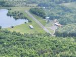
jmonroe
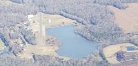
Jim Monroe
| FAA Information Effective | 2026-09-03 |
| Airport Identifier | 5NC2 |
| Airport Status | Operational |
| Longitude/Latitude |
80°30'41.1000"
W /
35°59'5.5000"
N -80.511417 / 35.984861 (Estimated) |
| Elevation | 731.00 ft / 222.81 m (Surveyed) |
| Land | 70 acres |
| From nearest city | 6 nautical miles NE of Mocksville, NC |
| Location | Davie County, NC |
| Magnetic Variation | 06W (1985) |
| Airport Use | Private |
| Wind indicator | Yes |
| Segmented Circle | No |
| Control Tower | NON-ATCT |
| Lighting Schedule | SEE RMK |
| Landing fee charge | No |
| Sectional chart | CHARLOTTE |
| Region | ASO - Southern |
| Traffic Pattern Alt | 769 ft |
| Responsible ARTCC | ZTL - ATLANTA |
| Tie-in FSS | RDU - RALEIGH |
| FSS on Airport | No |
| FSS Toll Free | 1-800-WX-BRIEF |
Runway 02L/20R
| Dimensions | 2424 x 36 ft (739 x 11 m) |
| Surface | ASPH (GOOD) |
| Surface treatment | |
| Edge lights | Non-standard lighting system |
| 02L | 20R | |
|---|---|---|
| Alignment | 10° | 190° |
| Physical elevation | 716.00 ft | 720.00 ft |
| Coordinates | 35.981570 / -80.512100 | 35.988133 / -80.510706 |
| Traffic pattern | Right | Left |
| Runway marking | Nonstandard , Fair Condition | Nonstandard , Fair Condition |
| Runway end lights | No | No |
| TDZ lights | No | No |
Runway 02R/20L
| Dimensions | 1000 x 35 ft (305 x 11 m) |
| Surface | TURF (GOOD) |
| Surface treatment |
| 02R | 20L | |
|---|---|---|
| Traffic pattern | Right | Left |