Surfside Seaplane Base (8Y4)
Surfside Seaplane Base (8Y4)
8Y4
Surfside Seaplane Base (8Y4)
Lino Lakes, MN
Latest photo of Surfside Seaplane Base (8Y4)
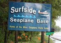
Timothy Aanerud
| FAA Information Effective | 2026-09-03 |
| Airport Identifier | 8Y4 |
| Airport Status | Operational |
| Longitude/Latitude |
93°7'24.5285"
W /
45°9'21.1785"
N -93.123480 / 45.155883 (Estimated) |
| Elevation | 880.00 ft / 268.22 m (Estimated) |
| Land | 20 acres |
| From nearest city | 2 nautical miles S of Lino Lakes, MN |
| Location | Anoka County, MN |
| Airport Use | Open to public |
| Wind indicator | Yes |
| Segmented Circle | No |
| Control Tower | NON-ATCT |
| Landing fee charge | No |
| Sectional chart | TWIN CITIES |
| Region | AGL - Great Lakes |
| Responsible ARTCC | ZMP - MINNEAPOLIS |
| Tie-in FSS | PNM - PRINCETON |
| FSS on Airport | No |
| FSS Toll Free | 1-800-WX-BRIEF |
| NOTAMs Facility | PNM (NOTAM-d service available) |
Runway 05W/23W
| Dimensions | 5503 x 500 ft (1677 x 152 m) |
| Surface | WATER (POOR) |
| Surface treatment |
| 05W | 23W | |
|---|---|---|
| Alignment | 53° | 233° |
| Physical elevation | 880.00 ft | 880.00 ft |
| Coordinates | 45.151296 / -93.131949 | 45.160470 / -93.115011 |
| Traffic pattern | Left | Left |
Runway N/S
| Dimensions | 2500 x 500 ft (762 x 152 m) |
| Surface | WATER |
| Surface treatment |
| N | S | |
|---|---|---|
| Physical elevation | 880.00 ft | 880.00 ft |
| Traffic pattern | Left | Left |