C.c.a. Heliport (9OH3)

9OH3
C.c.a. Heliport (9OH3)
Loveland, OH
Latest photo of C.c.a. Heliport (9OH3)
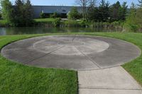
9OH3, The pad is still here, but the ownership of the adjacent building has changed., photo by Kevin Kuhn
Kevin Kuhn
Location & QuickFacts
FAA Information Effective 2013-12-12
Airport Identifier 9OH3
Airport Status Operational
Longitude/Latitude 084-17-51.7770W/39-17-00.2100N
-84.297716/39.283392 (Estimated)
Elevation 810 ft / 246.89 m (Estimated)
Land 10 acres
From nearest city 2 nautical miles SE of Loveland, OH
Location Clermont County, OH
Magnetic Variation 04W (1990)
Owner & Manager
Ownership Privately owned
Owner C.c.a., Inc.
Address 9501 Union-cemetary Road
Loveland, OH 45140
Phone number 513-871-3261
Manager Thomas Blaho
Address 9501 Union-cemetary Road
Loveland, OH 45140
Phone number 513-871-3261
Airport Operations and Facilities
Airport Use Private
Segmented Circle No
Control Tower No
Lighting Schedule SEE RMK
Sectional chart Detroit
Region AGL - Great Lakes
Boundary ARTCC ZID - Indianapolis
Tie-in FSS DAY - Dayton
FSS Toll Free 1-800-WX-BRIEF
Runway Information
Runway H1
Dimensions 25 x 25 ft (8 x 8 m)
Surface CONC
H1
Traffic pattern Left Left
Remarks
  • ALL APCH/DEPARTURE ROUTE OPERATIONS ARE CONDUCTED IN AN AREA TO/FROM 090/270 DEGS USING THE TOUCHDOWN PAD AS THE CENTER OF A COMPASS ROSE; TAKEOFF/LANDING AREA IS MARKED; A NON-OBSTRUCTING WIND INDICATOR IS MAINTAINED ADJACENT TO THE TAKEOFF/LANDING AREA.