Bert Mooney Airport (BTM)
Bert Mooney Airport (BTM)
BTM
Bert Mooney Airport (BTM)
Butte, MT
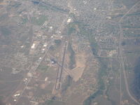
Latest photo of Bert Mooney Airport (BTM)
Ronald Barker
| FAA Information Effective | 2026-07-09 |
| Airport Identifier | BTM |
| Airport Status | Operational |
| Longitude/Latitude |
112°29'50.9000"
W /
45°57'17.3000"
N -112.497472 / 45.954806 (Estimated) |
| Elevation | 5550.50 ft / 1691.79 m (Surveyed) |
| Land | 890 acres |
| From nearest city | 3 nautical miles SE of Butte, MT |
| Location | Silver Bow County, MT |
| Magnetic Variation | 12E (2020) |
| Airport Use | Open to public |
| Wind indicator | Yes |
| Segmented Circle | Yes |
| Control Tower | NON-ATCT |
| Lighting Schedule | SEE RMK |
| Beacon Color | White-Green (lighted land airport) |
| Landing fee charge | Yes |
| Sectional chart | GREAT FALLS |
| Region | ANM - Northwest Mountain |
| Responsible ARTCC | ZLC - SALT LAKE CITY |
| Tie-in FSS | GTF - GREAT FALLS |
| FSS Toll Free | 1-800-WX-BRIEF |
| NOTAMs Facility | BTM (NOTAM-d service available) |
| Certification type/date | 1973/05 |
Runway 12/30
| Dimensions | 5100 x 75 ft (1554 x 23 m) |
| Surface | ASPH (GOOD) |
| Surface treatment | Saw-cut or plastic Grooved |
| Edge lights | Medium |
| 12 | 30 | |
|---|---|---|
| Alignment | 129° | 309° |
| Physical elevation | 5520.70 ft | 5530.60 ft |
| Coordinates | 45.958992 / -112.505736 | 45.950170 / -112.490187 |
| Traffic pattern | Left | Left |
| Runway marking | Basic , Good Condition | Basic , Good Condition |
| VGSI |
2-light PAPI on left *PAPI UNUSBL BYD 5 DEG RIGHT OF RCL. |
2-light PAPI on left *PAPI RSTRD TO 2.1 NM FM RWY 30 THLD DUE TO HIGH TERRAIN. PAPI UNUSBL BYD 2 DEG RIGHT OF RCL. |
| Runway end lights | Yes | Yes |
Runway 15/33
| Dimensions | 9000 x 150 ft (2743 x 46 m) |
| Surface | ASPH (GOOD) |
| Surface treatment | Saw-cut or plastic Grooved |
| Edge lights | Medium |
| 15 | 33 | |
|---|---|---|
| Alignment | 167° | 347° |
| Physical elevation | 5506.70 ft | 5550.40 ft |
| Coordinates | 45.966926 / -112.501202 | 45.942898 / -112.493166 |
| Traffic pattern | Right | Left |
| Runway marking | Precision instrument , Good Condition | Basic , Good Condition |
| ILS type | ILS/DME | |
| VGSI | 4-light PAPI on left |
2-box on left *DO NOT USE VASI BYD 1.5 MI DUE TO HIGH TERRAIN. |
| Approach light | MALSR | |
| Runway end lights | No | No |
- FOR CD IF UNA TO CTC ON FSS FREQ, CTC SALT LAKE ARTCC AT 801-320-2568.
- TWY D RSTD TO ACFT WITH WINGSPAN LESS THAN 100 FT WO PPR, CALL APMGR 406-494-3771.
- DEER IN VICINITY OF AIRPORT.
- SNOW REMOVAL OPS IN PROGRES DURING PERIODS OF SNOW.
- COLD TEMPERATURE AIRPORT. ALTITUDE CORRECTION REQUIRED AT OR BELOW -24C.