Jack Mc Namara Fld Airport (CEC / KCEC) — Crescent City, CA
Jack Mc Namara Fld Airport (CEC)
CEC
Jack Mc Namara Fld Airport (CEC)
Crescent City, CA
Latest photo of Jack Mc Namara Fld Airport (CEC)
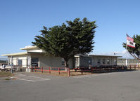
Jack Poelstra
Jack Mc Namara Fld Airport (CEC/KCEC) is a public-use airport located in Crescent City, CA. The airport sits at an elevation of 60 feet above mean sea level. It features 2 runways. Aviation communications are supported by 6 published radio frequencies. The gallery includes 1 photo of operations and aircraft at the airport.
| FAA Information Effective | 2026-09-03 |
| Airport Identifier | CEC |
| Airport Status | Operational |
| Longitude/Latitude |
124°14'11.5000"
W /
41°46'48.6000"
N -124.236528 / 41.780167 (Estimated) |
| Elevation | 60.70 ft / 18.50 m (Surveyed) |
| Land | 544 acres |
| From nearest city | 3 nautical miles NW of Crescent City, CA |
| Location | Del Norte County, CA |
| Magnetic Variation | 14E (2020) |
| Airport Use | Open to public |
| Wind indicator | Yes |
| Segmented Circle | Yes |
| Control Tower | NON-ATCT |
| Lighting Schedule | SEE RMK |
| Beacon Color | White-Green (lighted land airport) |
| Landing fee charge | No |
| Sectional chart | KLAMATH FALLS |
| Region | AWP - Western-Pacific |
| Responsible ARTCC | ZSE - SEATTLE |
| Tie-in FSS | OAK - OAKLAND |
| FSS on Airport | No |
| FSS Toll Free | 1-800-WX-BRIEF |
| NOTAMs Facility | CEC (NOTAM-d service available) |
| Certification type/date | 1985/05 |
Runway 12/30
| Dimensions | 5002 x 150 ft (1525 x 46 m) |
| Surface | ASPH (FAIR) |
| Surface treatment | |
| Edge lights | High |
| 12 | 30 | |
|---|---|---|
| Alignment | 133° | 313° |
| Physical elevation | 56.90 ft | 53.00 ft |
| Coordinates | 41.784993 / -124.241543 | 41.775599 / -124.228174 |
| Traffic pattern | Left | Left |
| Runway marking | Precision instrument , Fair Condition | Precision instrument , Fair Condition |
| ILS type | ILS | |
| VGSI | 4-box on left | |
| Approach light | MALSR | |
| Runway end lights | No | Yes |
| CL lights | No | No |
| TDZ lights | No | No |
Runway 18/36
| Dimensions | 5000 x 150 ft (1524 x 46 m) |
| Surface | ASPH (FAIR) |
| Surface treatment | |
| Edge lights | Medium |
| 18 | 36 | |
|---|---|---|
| Alignment | 193° | 13° |
| Physical elevation | 60.60 ft | 50.60 ft |
| Coordinates | 41.786718 / -124.236112 | 41.773360 / -124.240299 |
| Traffic pattern | Left | Left |
| Runway marking | Non-precision instrument , Fair Condition | Non-precision instrument , Fair Condition |
| VGSI | 4-box on left | |
| Runway end lights | Yes | Yes |
| CL lights | No | No |
| TDZ lights | No | No |
- A 150 FT LGTD TWR 3300 FT W CEC VOR.
- BIRDS AND DEER ON & INVOF ARPT.
- RIDGE LNS OF SHIFTING SAND DUNES 30-50 FT AGL AND 1000 FT OFF APCH END RWY 18.
- TSNT PRKG RAMP ESTD WGT LIMIT 20000 LBS, FBO RAMP ESTD WGT LIMIT 60000 LBS.
- FOR CD IF UNA TO CTC ON FSS FREQ, CTC SEATTLE ARTCC AT 253-351-3694.
- PRIOR TO 15 MAY 59