Chitina Airport (CXC)
Chitina Airport (CXC)
CXC
Chitina Airport (CXC)
Chitina, AK
Latest photo of Chitina Airport (CXC)
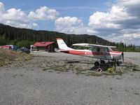
Jack Poelstra
| FAA Information Effective | 2026-07-09 |
| Airport Identifier | CXC |
| Airport Status | Operational |
| Longitude/Latitude |
144°25'47.2900"
W /
61°34'59.5300"
N -144.429803 / 61.583203 (Estimated) |
| Elevation | 556.00 ft / 169.47 m (Surveyed) |
| From nearest city | 4 nautical miles N of Chitina, AK |
| Location | Valdez-cordova County, AK |
| Magnetic Variation | 27E (1985) |
| Airport Use | Open to public |
| Wind indicator | Yes |
| Segmented Circle | Yes |
| Control Tower | NON-ATCT |
| Landing fee charge | No |
| Sectional chart | ANCHORAGE |
| Region | AAL - Alaska |
| Responsible ARTCC | ZAN - ANCHORAGE |
| Tie-in FSS | ENA - KENAI |
| FSS on Airport | No |
| FSS Phone | 907-283-7211 |
| FSS Toll Free | 1-866-864-1737 |
| NOTAMs Facility | ENA (NOTAM-d service available) |